-
IPCC の地上バイオマス Tier 1 推定値の全球 2020 年森林分類(V1)

このデータセットは、2020 年の森林の状態/状況によって区分された全球の森林クラスを約 30 m の解像度で提供します。このデータは、2006 年 IPCC 国家温室効果ガスインベントリ作成のためのガイドラインに対する 2019 年の改良版の天然林における地上乾燥木質バイオマス密度(AGBD)の Tier 1 推定値の生成をサポートしています。 地上バイオマス バイオマス 炭素 分類 森林 森林バイオマス -
地上および地下バイオマス炭素密度の全球マップ

このデータセットは、2010 年の地上および地下バイオマス炭素密度の時間的に一貫性のある調和された全球マップを 300 m の空間解像度で提供します。地上バイオマスマップは、森林、草原、農地、ツンドラバイオマスの土地被覆固有のリモートセンシング マップを統合したものです。入力マップは … 地上 バイオマス 炭素 密度 森林 森林バイオマス -
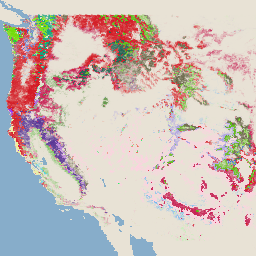
USFS TreeMap v2020

このプロダクトは TreeMap データスイートの一部です。2020 年の米国全土の森林範囲における、生木と枯れ木の数、バイオマス、炭素などの森林特性に関する詳細な空間情報を提供します。TreeMap v2020 には、22 バンドの 30 x 30 m の … 地上 バイオマス 炭素 気候変動 conus 森林 -
USFS TreeMap v2022
このプロダクトは TreeMap データスイートの一部です。2022 年の米国全土の森林範囲における、生木と枯れ木の数、バイオマス、炭素などの森林特性に関する詳細な空間情報を提供します。TreeMap v2022 には、22 バンドの 30 x 30 m の … 地上 バイオマス 炭素 気候変動 conus 森林 -
WHRC パン熱帯国家レベルの炭素貯留量データセット

熱帯諸国の地上生木質バイオマス密度の国家レベルのマップ(500 m)。このデータセットは、同じ場所でのフィールド測定、LiDAR 観測、中分解能撮像分光放射計(MODIS)で記録された画像を組み合わせて作成されました。 地上 バイオマス 炭素 森林バイオマス 地球物理学 umd
Datasets tagged aboveground in Earth Engine
[null,null,[],[],[]]