-
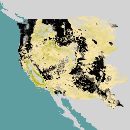
Landbedeckung von Nordamerika mit einer Auflösung von 30 Metern, 2020

Das 30‑Meter-Dataset zur Bodenbedeckung in Nordamerika aus dem Jahr 2020 wurde im Rahmen des North American Land Change Monitoring System (NALCMS) erstellt, einer trilateralen Initiative von Natural Resources Canada, dem United States Geological Survey und drei mexikanischen Organisationen, darunter dem National Institute of Statistics and Geography… landcover landsat landuse-landcover nlcd reflectance -
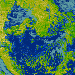
NLCD 2019: USGS National Land Cover Database, Version 2019

Die NLCD (National Land Cover Database) ist eine auf Landsat basierende Datenbank zur Bodenbedeckung mit einer Auflösung von 30 m, die acht Epochen (2001, 2004, 2006, 2008, 2011, 2013, 2016 und 2019) umfasst. Hier finden Sie auch eine neunte Epoche für 2021. Die Bilder basieren auf der Daten-Ebene für die Undurchlässigkeit für städtische … blm landcover landuse-landcover mrlc nlcd usgs -
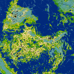
NLCD 2021: USGS National Land Cover Database, Version 2021

Der U.S. Geological Survey (USGS) hat in Zusammenarbeit mit mehreren Bundesbehörden sieben Produkte der National Land Cover Database (NLCD) entwickelt und veröffentlicht: NLCD 1992, 2001, 2006, 2011, 2016, 2019 und 2021. Ab 2016 wurden Landbedeckungsprodukte in zwei- bis dreijährigen Intervallen erstellt… blm landcover landuse-landcover mrlc nlcd usgs -
RCMAP Rangeland Component Timeseries (1985-2023), v06
'Der RCMAP-Datensatz (Rangeland Condition Monitoring Assessment and Projection) quantifiziert den prozentualen Anteil der Rangeland-Komponenten in West-Nordamerika anhand von Landsat-Bildern aus dem Zeitraum 1985 bis 2023. Die RCMAP-Produktfamilie besteht aus zehn fraktionierten Komponenten: jährliche krautige Vegetation, unbewachsener Boden, krautige Vegetation, Streu, Nicht-Beifuß-Sträucher, mehrjährige krautige Vegetation, Beifuß usw. climate-change disturbance landsat-derived landuse-landcover nlcd rangeland> -
RCMAP Rangeland Trends Year for Component Timeseries (1985-2023), v06
Diese Sammlung umfasst jährliche RCMAP-Produkte von 1985 bis 2023. Im RCMAP-Dataset (Rangeland Condition Monitoring Assessment and Projection) wird der prozentuale Anteil der Rangeland-Komponenten in West-Nordamerika anhand von Landsat-Bildern aus dem Zeitraum 1985 bis 2023 quantifiziert. Die RCMAP-Produktreihe besteht aus zehn fraktionierten Komponenten: jährlich … climate-change disturbance landsat-derived landuse-landcover nlcd rangeland> -
RCMAP Rangeland Trends for Component Timeseries (1985-2023), v06
Im RCMAP-Dataset (Rangeland Condition Monitoring Assessment and Projection) wird der prozentuale Anteil der Rangeland-Komponenten in West-Nordamerika anhand von Landsat-Bildern aus dem Zeitraum 1985 bis 2023 quantifiziert. Die RCMAP-Produktfamilie besteht aus zehn fraktionierten Komponenten: jährliche krautige Vegetation, unbewachsener Boden, krautige Vegetation, Streu, Nicht-Beifuß-Sträucher, mehrjährige krautige Vegetation, Beifuß usw. climate-change disturbance landsat-derived landuse-landcover nlcd rangeland>
Datasets tagged nlcd in Earth Engine
[null,null,[],[],[]]