-
Bilder zur Brandintensität aus dem MTBS-Programm (Monitoring Trends in Burn Severity)
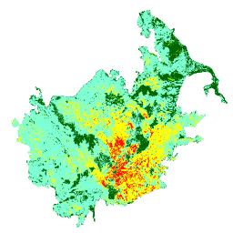
Die Mosaike zur Brandintensität bestehen aus thematischen Rasterbildern der MTBS-Klassen zur Brandintensität für alle derzeit abgeschlossenen MTBS-Brände in den kontinentalen Vereinigten Staaten, Alaska, Hawaii und Puerto Rico. Mosaike zur Brandintensität werden jährlich für jedes Jahr nach US-Bundesstaat zusammengestellt und … eros fire forest gtac landcover landsat-derived -
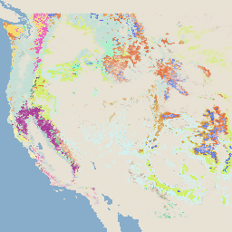
USFS Landscape Change Monitoring System v2025-11 (CONUS und OCONUS)

Dieses Produkt ist Teil der Datensuite des Landscape Change Monitoring System (LCMS). Es zeigt die von LCMS modellierten Veränderungen, die Landbedeckung und/oder die Landnutzungsklassen für jedes Jahr und umfasst die kontinentalen Vereinigten Staaten (CONUS) sowie Gebiete außerhalb der CONUS (OCONUS), einschließlich Alaska (AK), Puerto … change-detection forest gtac gtac-data-publish landcover landuse -
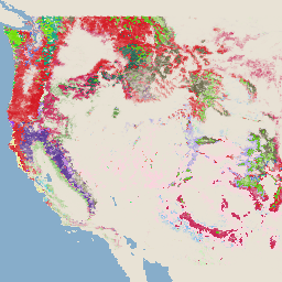
USFS Tree Canopy Cover v2025-6 (CONUS und OCONUS)

Die Datensuite „Tree Canopy Cover“ (TCC) wird vom United States Department of Agriculture, Forest Service (USFS) erstellt und umfasst jährliche, auf Fernerkundung basierende Kartenausgaben aus den Jahren 1985 bis 2025. Diese Daten unterstützen das Projekt „National Land Cover Database“ (NLCD), das vom US Geological Survey … forest gtac gtac-data-publish landuse-landcover publisher-dataset redcastle-resources -
USFS TreeMap v2016 (kontinentale USA)
Dieses Produkt ist Teil der Datensuite „TreeMap“. Es enthält detaillierte räumliche Informationen zu den Waldeigenschaften, einschließlich der Anzahl lebender und toter Bäume, der Biomasse und des Kohlenstoffs im gesamten Waldgebiet der kontinentalen Vereinigten Staaten im Jahr 2016. TreeMap v2016 enthält ein Bild, ein … biomass carbon climate-change conus forest forest-biomass -
USFS TreeMap v2020
Dieses Produkt ist Teil der Datensuite „TreeMap“. Es enthält detaillierte räumliche Informationen zu den Waldeigenschaften, einschließlich der Anzahl lebender und toter Bäume, der Biomasse und des Kohlenstoffs im gesamten Waldgebiet der Vereinigten Staaten im Jahr 2020. TreeMap v2020 enthält ein 22-Band-Bild mit einer Auflösung von 30 × 30 Metern … aboveground biomass carbon climate-change conus forest -
USFS TreeMap v2022

Dieses Produkt ist Teil der Datensuite „TreeMap“. Es enthält detaillierte räumliche Informationen zu den Waldeigenschaften, einschließlich der Anzahl lebender und toter Bäume, der Biomasse und des Kohlenstoffs im gesamten Waldgebiet der Vereinigten Staaten im Jahr 2022. TreeMap v2022 enthält ein 22-Band-Bild mit einer Auflösung von 30 × 30 Metern … aboveground biomass carbon climate-change conus forest
Datasets tagged redcastle-resources in Earth Engine
[null,null,[],[],[]]