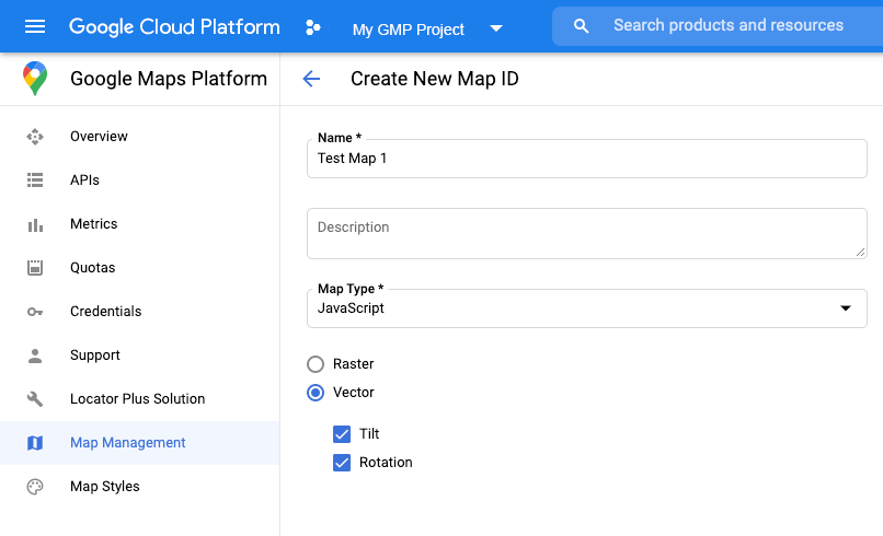
您还可以使用地图 ID 指定渲染类型。如需创建新的地图 ID,请按照使用云端地图样式设置 - 获取地图 ID 一文中的步骤操作。请务必将地图类型设置为 JavaScript,然后选择矢量选项。选中倾斜和/或旋转,以在地图上启用倾斜和旋转。这样一来,您便能以程序化方式调整这些值,还能让用户直接在地图上调整倾斜度和朝向。如果使用倾斜或朝向会对应用产生不利影响,则不要选中倾斜和旋转,这样用户就无法调整倾斜度和旋转度。
接下来,使用您创建的地图 ID 更新地图初始化代码。您可以在地图管理页面上找到地图 ID。在实例化地图时,请通过 mapId 属性提供地图 ID,如下所示:
[null,null,["最后更新时间 (UTC):2025-08-31。"],[[["\u003cp\u003eWebGL-powered features for Maps JavaScript API enable control over tilt and rotation, addition of 3D objects, and custom 2D/3D graphics with WebGL Overlay View.\u003c/p\u003e\n"],["\u003cp\u003eTo utilize WebGL features, use a vector map by specifying \u003ccode\u003erenderingType: RenderingType.VECTOR\u003c/code\u003e during map initialization or by using a map ID with the vector option enabled.\u003c/p\u003e\n"],["\u003cp\u003eTilt and rotation can be controlled programmatically or through user interaction by enabling \u003ccode\u003etiltInteractionEnabled\u003c/code\u003e and \u003ccode\u003eheadingInteractionEnabled\u003c/code\u003e map options.\u003c/p\u003e\n"],["\u003cp\u003eThe \u003ccode\u003e<gmp-map>\u003c/code\u003e element automatically enables vector maps, tilt, and heading by default, simplifying integration.\u003c/p\u003e\n"],["\u003cp\u003eSeveral examples and demos are available to explore the capabilities and implementation of WebGL features in Maps JavaScript API.\u003c/p\u003e\n"]]],[],null,["\u003cbr /\u003e\n\nWebGL-powered features for Maps JavaScript API let you\ncontrol tilt and rotation, add 3D objects directly to the map, and more. The\nfollowing features are included:\n\n- [WebGL Overlay View](/maps/documentation/javascript/webgl/webgl-overlay-view) lets you add custom 2D and 3D graphics and animated content to your maps.\n- [Tilt and heading](/maps/documentation/javascript/vector-map#tilt-rotation) can now be adjusted programmatically, and by using mouse and keyboard gestures.\n- [map.moveCamera()](/maps/documentation/javascript/vector-map#control-camera) lets you simultaneously change multiple camera properties.\n- Zoom now supports [fractional values](/maps/documentation/javascript/vector-map#fractional-zoom).\n\nGet started\n\nIn order to use the new WebGL features, you must use a vector map. This section\nshows you how.\n\nSpecify the `renderingType` option\n\nUse the `renderingType` option to specify either the raster or vector\nrendering type for your map (no map ID required):\n\n1. Load the `RenderingType` library; this can be done when loading the Maps\n library:\n\n const { Map, RenderingType } = await google.maps.importLibrary(\"maps\") as google.maps.MapsLibrary;\n\n2. When initializing the map, use the `renderingType` option to specify either\n `RenderingType.VECTOR` or `RenderingType.RASTER`:\n\n map = new Map(\n document.getElementById('map') as HTMLElement,\n {\n zoom: 4,\n center: position,\n renderingType: RenderingType.VECTOR,\n }\n );\n\nThe `renderingType` option overrides any rendering type settings made by\nconfiguring a map ID.\n\n- To enable tilt and rotation, set the `tiltInteractionEnabled` map option to true or call `map.setTiltInteractionEnabled`.\n- To enable panning, set the `headingInteractionEnabled` map option to `true` or call `map.setHeadingInteractionEnabled`.\n\nUse a map ID to set rendering type\n\nYou can also specify the rendering type by using a map ID. To create a new map\nID, follow the steps in [Using Cloud-based Map Styling - Get a map ID](/maps/documentation/javascript/styling#creating-map-ids).\nBe sure to set the Map type to **JavaScript** , and select the **Vector**\noption. Check **Tilt** or **Rotation** to enable tilt and rotation on the\nmap. Doing so lets you programmatically adjust these values, and also\nlets users adjust tilt and heading directly on the map. If the use of tilt or\nheading will adversely affect your app, leave **Tilt** and **Rotation** un-\nchecked so users cannot adjust tilt and rotation.\n\nNext, update your map initialization code with the map ID you created. You can\nfind your map IDs on the\n[Maps\nManagement](https://console.cloud.google.com/google/maps-apis/studio/maps) page. Provide a map ID when you instantiate the map using the\n`mapId` property as shown here: \n\n```javascript\nmap = new google.maps.Map(document.getElementById('map'), {\n center: {lat: -34.397, lng: 150.644},\n zoom: 8,\n mapId: '\u003cvar translate=\"no\"\u003eMAP_ID\u003c/var\u003e'\n});\n```\n| **Important:** It is recommended to associate your map ID and API key with the same Google Cloud console project.\n\nUse the `\u003cgmp-map\u003e` element\n\nVector maps, tilt, and heading are enabled by default when using he `\u003cgmp-map\u003e`\nelement, which lets you add a map to your page using HTML. [Learn more](/maps/documentation/javascript/add-google-map-wc-tut).\n\nExamples\n\nExamples have been provided to demonstrate these features:\n\n- [WebGL Overlay View](/maps/documentation/javascript/examples/webgl/webgl-overlay-simple)\n- [WebGL Tilt and Rotation](/maps/documentation/javascript/examples/webgl/webgl-tilt-rotation)\n- [WebGL Feature Tour](https://goo.gle/maps-platform-webgl-tour)\n- [WebGL Travel App Demo](https://goo.gle/maps-platform-webgl-travel-demo)"]]