
ทำตามขั้นตอนต่อไปนี้เพื่อตั้งค่าการจัดรูปแบบตามข้อมูลสำหรับชุดข้อมูล
รับคีย์ API และเปิดใช้ API
ก่อนใช้การจัดรูปแบบตามข้อมูลสำหรับชุดข้อมูล คุณต้องมีสิ่งต่อไปนี้ โปรเจ็กต์ที่อยู่ในระบบคลาวด์ของ Google Cloud ที่มีบัญชีสำหรับการเรียกเก็บเงิน รวมถึงเปิดใช้ทั้ง Maps JavaScript API และ Maps Datasets API ดูข้อมูลเพิ่มเติมได้ที่ ตั้งค่าโปรเจ็กต์ Google Cloud
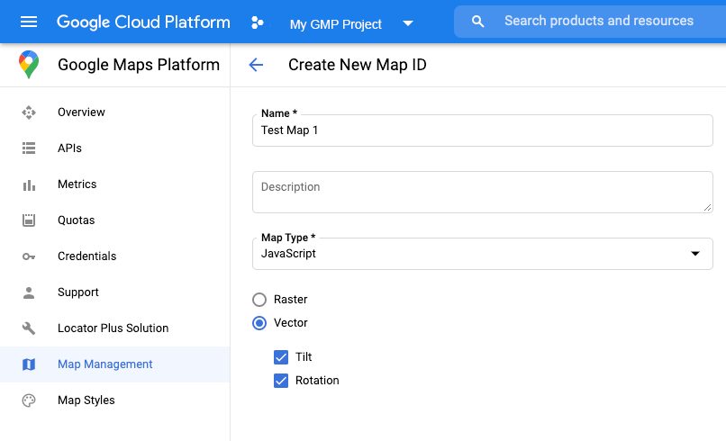
สร้างรหัสแผนที่
หากต้องการสร้างรหัสแผนที่ใหม่ ให้ทำตามขั้นตอนใน ส่วนการปรับแต่งระบบคลาวด์ ตั้งค่าประเภทแผนที่เป็น JavaScript แล้วเลือกตัวเลือก Vector
ระบุรหัสแผนที่โดยใช้พร็อพเพอร์ตี้ mapId เมื่อสร้างอินสแตนซ์ของแผนที่
รหัสแผนที่ต้องสอดคล้องกับรูปแบบแผนที่ที่เชื่อมโยงกับชุดข้อมูลที่จะแสดง
const position = new google.maps.LatLng(40.75, -74.05);
const map = new google.maps.Map(document.getElementById('map'), {
  zoom: 11,
  center: position,
  mapId: 'YOUR_MAP_ID',
});
สร้างรูปแบบแผนที่ใหม่
หากต้องการสร้างรูปแบบแผนที่ใหม่ ให้ทำตามวิธีการใน สร้างและใช้รูปแบบแผนที่ เพื่อสร้างรูปแบบ แล้ว เชื่อมโยงรูปแบบกับรหัสแผนที่ที่สร้างขึ้น
อัปเดตโค้ดการเริ่มต้นแผนที่
หากต้องการใช้การจัดรูปแบบตามข้อมูลสำหรับชุดข้อมูล ให้โหลด Maps JavaScript API ก่อนโดยเพิ่มตัวโหลด Bootstrap แบบอินไลน์ลงในโค้ดของแอปพลิเคชัน ดังที่แสดงไว้ที่นี่ (ใช้ v=beta ในแท็ก script ของ API)
<script>
  (g=>{var h,a,k,p="The Google Maps JavaScript API",c="google",l="importLibrary",q="__ib__",m=document,b=window;b=b[c]||(b[c]={});var d=b.maps||(b.maps={}),r=new Set,e=new URLSearchParams,u=()=>h||(h=new Promise(async(f,n)=>{await (a=m.createElement("script"));e.set("libraries",[...r]+"");for(k in g)e.set(k.replace(/[A-Z]/g,t=>"_"+t[0].toLowerCase()),g[k]);e.set("callback",c+".maps."+q);a.src=`https://maps.${c}apis.com/maps/api/js?`+e;d[q]=f;a.onerror=()=>h=n(Error(p+" could not load."));a.nonce=m.querySelector("script[nonce]")?.nonce||"";m.head.append(a)}));d[l]?console.warn(p+" only loads once. Ignoring:",g):d[l]=(f,...n)=>r.add(f)&&u().then(()=>d[l](f,...n))})({
    key: "YOUR_API_KEY",
    v: "weekly",
    // Use the 'v' parameter to indicate the version to use (weekly, beta, alpha, etc.).
    // Add other bootstrap parameters as needed, using camel case.
  });
</script>
ตรวจสอบความสามารถของแผนที่ (ไม่บังคับ)
การจัดรูปแบบตามข้อมูลสำหรับชุดข้อมูลต้องใช้รหัสแผนที่ หากไม่มีรหัสแผนที่หรือมีการส่งรหัสแผนที่ที่ไม่ถูกต้อง ฟีเจอร์ข้อมูลจะโหลดไม่ได้ คุณสามารถเพิ่ม Listener mapcapabilities_changed เพื่อสมัครรับข้อมูลการเปลี่ยนแปลงความสามารถของแผนที่เป็นขั้นตอนการแก้ปัญหา ซึ่งจะระบุว่าตรงตามเงื่อนไขต่อไปนี้หรือไม่
- มีการใช้รหัสแผนที่ที่ถูกต้อง
- รหัสแผนที่เชื่อมโยงกับแผนที่เวกเตอร์
การใช้ความสามารถของแผนที่เป็นตัวเลือกและแนะนำให้ใช้เพื่อการทดสอบและการแก้ปัญหาเท่านั้น หรือเพื่อวัตถุประสงค์ในการย้อนกลับรันไทม์
// Optional: subscribe to map capability changes.
map.addListener('mapcapabilities_changed', () => {
  const mapCapabilities = map.getMapCapabilities();

  if (!mapCapabilities.isDataDrivenStylingAvailable) {
    // Data-driven styling is *not* available, add a fallback.
    // Existing feature layers are also unavailable.
  }
});