البدء
تنظيم صفحاتك في مجموعات
يمكنك حفظ المحتوى وتصنيفه حسب إعداداتك المفضّلة.
اختيار النظام الأساسي:
Android
iOS
JavaScript
اتّبِع الخطوات التالية لإعداد ميزة "التصميم المستند إلى البيانات" لمجموعات البيانات.
الحصول على مفتاح واجهة برمجة التطبيقات وتفعيل واجهات برمجة التطبيقات
قبل استخدام ميزة "تحديد الأنماط المستند إلى البيانات" لمجموعات البيانات، يجب استيفاء ما يلي:
مشروع Google Cloud يتضمّن حساب فوترة، وتفعيل كلّ من
Maps JavaScript API وMaps Datasets API.
لمزيد من المعلومات، يُرجى الاطّلاع على إعداد مشروعك على Google Cloud.
الحصول على مفتاح واجهة برمجة التطبيقات
تفعيل Maps JavaScript API
تفعيل Maps Datasets API
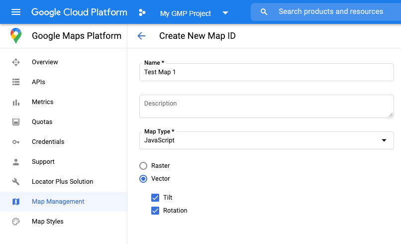
إنشاء رقم تعريف خريطة
لإنشاء معرّف خريطة جديد،
اتّبِع الخطوات الواردة في
تخصيص الخريطة على السحابة الإلكترونية.
اضبط "نوع الخريطة" على JavaScript، ثم اختَر الخيار متّجه.
قدِّم معرّف خريطة باستخدام السمة mapId
عند إنشاء مثيل للخريطة .
يجب أن يتطابق معرّف الخريطة مع نمط الخريطة المرتبط بمجموعة البيانات
التي سيتم عرضها.
const position = new google.maps.LatLng(40.75, -74.05);
const map = new google.maps.Map(document.getElementById('map'), {
zoom: 11,
center: position,
mapId: 'YOUR_MAP_ID',
});
إنشاء نمط خريطة جديد
لإنشاء نمط خريطة جديد، اتّبِع التعليمات الواردة في مقالة
إنشاء أنماط الخرائط واستخدامها
لإنشاء النمط، ثم
ربط النمط بمعرّف الخريطة الذي أنشأته للتو.
تعديل رمز تهيئة الخريطة
لاستخدام ميزة "تنسيق مستند إلى البيانات" لمجموعات البيانات، عليك أولاً تحميل Maps JavaScript API من خلال إضافة أداة تحميل bootstrap المضمّنة إلى رمز تطبيقك، كما هو موضّح هنا (استخدِم v=beta
في علامة script
لواجهة برمجة التطبيقات):
<script>
(g=>{var h,a,k,p="The Google Maps JavaScript API",c="google",l="importLibrary",q="__ib__",m=document,b=window;b=b[c]||(b[c]={});var d=b.maps||(b.maps={}),r=new Set,e=new URLSearchParams,u=()=>h||(h=new Promise(async(f,n)=>{await (a=m.createElement("script"));e.set("libraries",[...r]+"");for(k in g)e.set(k.replace(/[A-Z]/g,t=>"_"+t[0].toLowerCase()),g[k]);e.set("callback",c+".maps."+q);a.src=`https://maps.${c}apis.com/maps/api/js?`+e;d[q]=f;a.onerror=()=>h=n(Error(p+" could not load."));a.nonce=m.querySelector("script[nonce]")?.nonce||"";m.head.append(a)}));d[l]?console.warn(p+" only loads once. Ignoring:",g):d[l]=(f,...n)=>r.add(f)&&u().then(()=>d[l](f,...n))})({
key: "YOUR_API_KEY",
v: "weekly",
// Use the 'v' parameter to indicate the version to use (weekly, beta, alpha, etc.).
// Add other bootstrap parameters as needed, using camel case.
});
</script>
التحقّق من إمكانيات الخريطة (اختياري)
يتطلّب التصميم المستند إلى البيانات لمجموعات البيانات معرّف خريطة. إذا كان معرّف الخريطة غير متوفّر،
أو تم تمرير معرّف خريطة غير صالح، لن يتم تحميل ميزات البيانات. كخطوة لتحديد المشاكل وحلّها، يمكنك إضافة أداة معالجة mapcapabilities_changed
للاشتراك في تغييرات إمكانات الخريطة. سيشير ذلك إلى ما إذا تم استيفاء الشروط التالية:
- يتم استخدام رقم تعريف خريطة صالح.
- يرتبط معرّف الخريطة بخريطة متّجهة.
استخدام "إمكانات الخرائط" اختياري، ولا يُنصح به إلا لأغراض الاختبار وتحديد المشاكل وحلّها، أو لأغراض التراجع عن الإصدار في وقت التشغيل.
// Optional: subscribe to map capability changes.
map.addListener('mapcapabilities_changed', () => {
const mapCapabilities = map.getMapCapabilities();
if (!mapCapabilities.isDataDrivenStylingAvailable) {
// Data-driven styling is *not* available, add a fallback.
// Existing feature layers are also unavailable.
}
});
الخطوات التالية
إنّ محتوى هذه الصفحة مرخّص بموجب ترخيص Creative Commons Attribution 4.0 ما لم يُنصّ على خلاف ذلك، ونماذج الرموز مرخّصة بموجب ترخيص Apache 2.0. للاطّلاع على التفاصيل، يُرجى مراجعة سياسات موقع Google Developers. إنّ Java هي علامة تجارية مسجَّلة لشركة Oracle و/أو شركائها التابعين.
تاريخ التعديل الأخير: 2025-08-31 (حسب التوقيت العالمي المتفَّق عليه)
[null,null,["تاريخ التعديل الأخير: 2025-08-31 (حسب التوقيت العالمي المتفَّق عليه)"],[[["\u003cp\u003eTo utilize data-driven styling for datasets, obtain an API key, enable necessary APIs (Maps JavaScript API and Maps Datasets API), and create a map ID associated with a vector-based map style.\u003c/p\u003e\n"],["\u003cp\u003eInitialization involves providing the map ID during map instantiation and loading the Maps JavaScript API with the \u003ccode\u003ev=beta\u003c/code\u003e parameter in the script tag.\u003c/p\u003e\n"],["\u003cp\u003eFor troubleshooting, optionally use the \u003ccode\u003emapcapabilities_changed\u003c/code\u003e listener to verify map capabilities, such as a valid map ID linked to a vector map, ensuring data-driven styling functionality.\u003c/p\u003e\n"],["\u003cp\u003eAfter setup, proceed to create and upload a dataset to leverage data-driven styling within your maps.\u003c/p\u003e\n"]]],["To utilize data-driven styling, first get an API key and enable the Maps JavaScript and Datasets APIs. Create a map ID of type \"JavaScript\" and \"Vector,\" then associate it with a new map style. In the map initialization code, use the `mapId` property with your created ID and load the Maps JavaScript API with an inline bootstrap loader. Optionally, use a `mapcapabilities_changed` listener to ensure a valid map ID is used and troubleshoot any issues.\n"],null,["Select platform: [Android](/maps/documentation/android-sdk/dds-datasets/start \"View this page for the Android platform docs.\") [iOS](/maps/documentation/ios-sdk/dds-datasets/start \"View this page for the iOS platform docs.\") [JavaScript](/maps/documentation/javascript/dds-datasets/start \"View this page for the JavaScript platform docs.\")\n\n\u003cbr /\u003e\n\nFollow these steps to get set up with the data-driven styling for datasets.\n\nGet an API key and enable APIs\n\nBefore using the data-driven styling for datasets, you need:\nGoogle Cloud project with a billing account, and both the\nMaps JavaScript API and the Maps Datasets API enabled.\nTo learn more, see\n[Set up your Google Cloud project](/maps/documentation/javascript/cloud-setup).\n\n[Get an API key](/maps/documentation/javascript/get-api-key)\n\n\n[Enable the Maps JavaScript API](https://console.cloud.google.com/apis/library/maps-backend.googleapis.com)\n\n\n[Enable the Maps Datasets API](https://console.cloud.google.com/apis/library/mapsplatformdatasets.googleapis.com)\n\nCreate a map ID\n\nTo create a new [map ID](/maps/documentation/javascript/map-ids/mapid-over),\nfollow the steps in\n[Cloud customization](/maps/documentation/javascript/map-ids/get-map-id).\nSet the Map type to **JavaScript** , and select the **Vector** option.\n\nProvide a map ID using the `mapId` property when you instantiate the map .\nThe map ID must correspond to the map style that is associated with the dataset\nto display. \n\n```javascript\nconst position = new google.maps.LatLng(40.75, -74.05);\nconst map = new google.maps.Map(document.getElementById('map'), {\n zoom: 11,\n center: position,\n mapId: 'YOUR_MAP_ID',\n});\n```\n\nCreate a new map style\n\nTo create a new map style, follow the instructions in\n[Create and use map styles](/maps/documentation/javascript/cloud-customization/map-styles-leg)\nto create the style, and\n[associate the style with the map ID you just created](/maps/documentation/javascript/cloud-customization/map-styles-leg#associate-style-with-map-id).\n\nUpdate your map initialization code\n\nTo use the data-driven styling for datasets, first load the\nMaps JavaScript API, by adding the inline bootstrap loader to\nyour application code, as shown here\n(use `v=beta` in your API `script` tag): \n\n```javascript\n\u003cscript\u003e\n (g=\u003e{var h,a,k,p=\"The Google Maps JavaScript API\",c=\"google\",l=\"importLibrary\",q=\"__ib__\",m=document,b=window;b=b[c]||(b[c]={});var d=b.maps||(b.maps={}),r=new Set,e=new URLSearchParams,u=()=\u003eh||(h=new Promise(async(f,n)=\u003e{await (a=m.createElement(\"script\"));e.set(\"libraries\",[...r]+\"\");for(k in g)e.set(k.replace(/[A-Z]/g,t=\u003e\"_\"+t[0].toLowerCase()),g[k]);e.set(\"callback\",c+\".maps.\"+q);a.src=`https://maps.${c}apis.com/maps/api/js?`+e;d[q]=f;a.onerror=()=\u003eh=n(Error(p+\" could not load.\"));a.nonce=m.querySelector(\"script[nonce]\")?.nonce||\"\";m.head.append(a)}));d[l]?console.warn(p+\" only loads once. Ignoring:\",g):d[l]=(f,...n)=\u003er.add(f)&&u().then(()=\u003ed[l](f,...n))})({\n key: \"YOUR_API_KEY\",\n v: \"weekly\",\n // Use the 'v' parameter to indicate the /maps/documentation/javascript/versions to use (weekly, beta, alpha, etc.).\n // Add other /maps/documentation/javascript/load-maps-js-api#required_parameters as needed, using camel case.\n });\n\u003c/script\u003e\n```\n\nCheck map capabilities (optional)\n\nData-driven styling for datasets requires a map ID. If the map ID is missing,\nor an invalid map ID is passed, data features cannot load. As a\ntroubleshooting step, you can add a `mapcapabilities_changed` listener to\nsubscribe to map capability changes. This will indicate whether the following\nconditions have been met:\n\n- A valid map ID is in use.\n- The map ID is associated with a vector map.\n\nUsing Map Capabilities is optional, and recommended only for testing and\ntroubleshooting purposes, or for runtime fallback purposes. \n\n```javascript\n// Optional: subscribe to map capability changes.\nmap.addListener('mapcapabilities_changed', () =\u003e {\n const mapCapabilities = map.getMapCapabilities();\n\n if (!mapCapabilities.isDataDrivenStylingAvailable) {\n // Data-driven styling is *not* available, add a fallback.\n // Existing feature layers are also unavailable.\n }\n});\n```\n\nNext steps\n\n- [Create and upload a dataset](/maps/documentation/javascript/dds-datasets/create-dataset)"]]