 Visualizza il codice sorgente su GitHub
Gli oggetti ee.Image hanno un insieme di metodi relazionali, condizionali e booleani per
costruire espressioni di presa di decisione. I risultati di questi metodi sono utili per limitare
l'analisi a determinati pixel o regioni tramite il mascheramento, lo sviluppo di mappe classificate e la riassegnazione dei valori.
Operatori relazionali e booleani
I metodi relazionali includono:
eq(), gt(), gte(), lt() e
lte()
I metodi booleani includono:
Editor di codice (JavaScript)
and(), or() e not()
Colab (Python)
And(), Or() e Not()
Per eseguire confronti pixel per pixel tra le immagini, utilizza gli operatori di relazione. Per estrarre le aree urbanizzate in un'immagine, questo esempio utilizza gli operatori relazionali per impostare una soglia per gli indici spettrali, combinando le soglie con l'operatore and:
Editor di codice (JavaScript)
// Load a Landsat 8 image.
var image = ee.Image('LANDSAT/LC08/C02/T1_TOA/LC08_044034_20140318');

// Create NDVI and NDWI spectral indices.
var ndvi = image.normalizedDifference(['B5', 'B4']);
var ndwi = image.normalizedDifference(['B3', 'B5']);

// Create a binary layer using logical operations.
var bare = ndvi.lt(0.2).and(ndwi.lt(0));

// Mask and display the binary layer.
Map.setCenter(-122.3578, 37.7726, 12);
Map.setOptions('satellite');
Map.addLayer(bare.selfMask(), {}, 'bare');
import ee
import geemap.core as geemap
Colab (Python)
# Load a Landsat 8 image.
image = ee.Image('LANDSAT/LC08/C02/T1_TOA/LC08_044034_20140318')

# Create NDVI and NDWI spectral indices.
ndvi = image.normalizedDifference(['B5', 'B4'])
ndwi = image.normalizedDifference(['B3', 'B5'])

# Create a binary layer using logical operations.
bare = ndvi.lt(0.2).And(ndwi.lt(0))

# Define a map centered on San Francisco Bay.
map_bare = geemap.Map(center=[37.7726, -122.3578], zoom=12)

# Add the masked image layer to the map and display it.
map_bare.add_layer(bare.selfMask(), None, 'bare')
display(map_bare)
Come illustrato da questo esempio, l'output degli operatori relazionali e booleani è
true (1) o false (0). Per mascherare gli zeri, puoi mascherare l'immagine binaria risultante
con se stessa utilizzando selfMask().

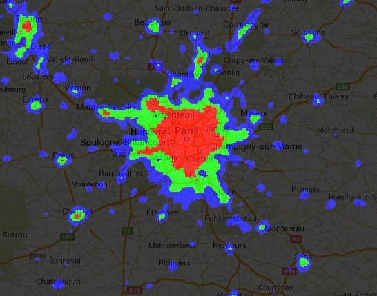
Le immagini binarie restituite dagli operatori relazionali e booleani possono essere utilizzate con gli operatori matematici. Questo esempio crea zone di urbanizzazione in un'immagine notturna con luci utilizzando gli operatori relazionali e add():
Editor di codice (JavaScript)
// Load a 2012 nightlights image.
var nl2012 = ee.Image('NOAA/DMSP-OLS/NIGHTTIME_LIGHTS/F182012');
var lights = nl2012.select('stable_lights');

// Define arbitrary thresholds on the 6-bit stable lights band.
var zones = lights.gt(30).add(lights.gt(55)).add(lights.gt(62));

// Display the thresholded image as three distinct zones near Paris.
var palette = ['000000', '0000FF', '00FF00', 'FF0000'];
Map.setCenter(2.373, 48.8683, 8);
Map.addLayer(zones, {min: 0, max: 3, palette: palette}, 'development zones');
import ee
import geemap.core as geemap
Colab (Python)
# Load a 2012 nightlights image.
nl_2012 = ee.Image('NOAA/DMSP-OLS/NIGHTTIME_LIGHTS/F182012')
lights = nl_2012.select('stable_lights')

# Define arbitrary thresholds on the 6-bit stable lights band.
zones = lights.gt(30).add(lights.gt(55)).add(lights.gt(62))

# Define a map centered on Paris, France.
map_zones = geemap.Map(center=[48.8683, 2.373], zoom=8)

# Display the thresholded image as three distinct zones near Paris.
palette = ['000000', '0000FF', '00FF00', 'FF0000']
map_zones.add_layer(
    zones, {'min': 0, 'max': 3, 'palette': palette}, 'development zones'
)
display(map_zones)
Operatori condizionali
Tieni presente che il codice nell'esempio precedente è equivalente all'utilizzo di un
operatore ternario implementato da
expression():
Editor di codice (JavaScript)
// Create zones using an expression, display.
var zonesExp = nl2012.expression(
    "(b('stable_lights') > 62) ? 3" +
      ": (b('stable_lights') > 55) ? 2" +
        ": (b('stable_lights') > 30) ? 1" +
          ": 0"
);
Map.addLayer(zonesExp,
             {min: 0, max: 3, palette: palette},
             'development zones (ternary)');
import ee
import geemap.core as geemap
Colab (Python)
# Create zones using an expression, display.
zones_exp = nl_2012.expression(
    "(b('stable_lights') > 62) ? 3 "
    ": (b('stable_lights') > 55) ? 2 "
    ": (b('stable_lights') > 30) ? 1 "
    ': 0'
)

# Define a map centered on Paris, France.
map_zones_exp = geemap.Map(center=[48.8683, 2.373], zoom=8)

# Add the image layer to the map and display it.
map_zones_exp.add_layer(
    zones_exp, {'min': 0, 'max': 3, 'palette': palette}, 'zones exp'
)
display(map_zones_exp)
Tieni presente che nell'esempio di espressione precedente viene fatto riferimento alla fascia di interesse utilizzando
la funzione b() anziché un dizionario di nomi di variabili. Scopri di più sulle espressioni delle immagini su questa pagina. L'utilizzo di operatori matematici o di un'espressione produrrà lo stesso risultato.
Un altro modo per implementare operazioni condizionali sulle immagini è con l'operatore
where(). Valuta la necessità di sostituire i pixel mascherati con altri dati. Nell'esempio seguente, i pixel nuvolosi vengono sostituiti dai pixel di un'immagine senza nuvole utilizzando where():
Editor di codice (JavaScript)
// Load a cloudy Sentinel-2 image.
var image = ee.Image(
  'COPERNICUS/S2_SR/20210114T185729_20210114T185730_T10SEG');
Map.addLayer(image,
             {bands: ['B4', 'B3', 'B2'], min: 0, max: 2000},
             'original image');

// Load another image to replace the cloudy pixels.
var replacement = ee.Image(
  'COPERNICUS/S2_SR/20210109T185751_20210109T185931_T10SEG');

// Set cloudy pixels (greater than 5% probability) to the other image.
var replaced = image.where(image.select('MSK_CLDPRB').gt(5), replacement);

// Display the result.
Map.setCenter(-122.3769, 37.7349, 11);
Map.addLayer(replaced,
             {bands: ['B4', 'B3', 'B2'], min: 0, max: 2000},
             'clouds replaced');
import ee
import geemap.core as geemap
Colab (Python)
# Load a cloudy Sentinel-2 image.
image = ee.Image('COPERNICUS/S2_SR/20210114T185729_20210114T185730_T10SEG')

# Load another image to replace the cloudy pixels.
replacement = ee.Image(
    'COPERNICUS/S2_SR/20210109T185751_20210109T185931_T10SEG'
)

# Set cloudy pixels (greater than 5% probability) to the other image.
replaced = image.where(image.select('MSK_CLDPRB').gt(5), replacement)

# Define a map centered on San Francisco Bay.
map_replaced = geemap.Map(center=[37.7349, -122.3769], zoom=11)

# Display the images on a map.
vis_params = {'bands': ['B4', 'B3', 'B2'], 'min': 0, 'max': 2000}
map_replaced.add_layer(image, vis_params, 'original image')
map_replaced.add_layer(replaced, vis_params, 'clouds replaced')
display(map_replaced)