הודעה: כל הפרויקטים הלא מסחריים שנרשמו לשימוש ב-Earth Engine לפני 15 באפריל 2025 חייבים לעבור אימות של הזכאות לשימוש לא מסחרי כדי לשמור על הגישה ל-Earth Engine.
קל לארגן דפים בעזרת אוספים
אפשר לשמור ולסווג תוכן על סמך ההעדפות שלך.
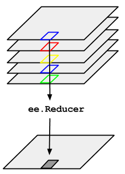
ניקח לדוגמה את הצורך לחשב את החציון של סדרת תמונות לאורך זמן, שמיוצגת על ידי ImageCollection. כדי להקטין את ImageCollection, משתמשים ב-imageCollection.reduce(). כך האוסף של התמונות מצומצם לתמונה אחת, כפי שמוצג באיור 1. באופן ספציפי, הפלט מחושב לפי פיקסלים, כך שכל פיקסל בפלט מורכב מהערך החציוני של כל התמונות באוסף במיקום הזה. כדי לקבל נתונים סטטיסטיים אחרים, כמו ממוצע, סכום, סטיית תקן, אחוזון שרירותי וכו', צריך לבחור את המצמצם המתאים ולהחיל אותו. (בכרטיסייה Docs בCode Editor מופיעה רשימה של כל המצמצמים הזמינים כרגע). לנתונים סטטיסטיים בסיסיים כמו מינימום, מקסימום, ממוצע וכו',
ל-ImageCollection יש שיטות קיצור כמו min(), max(), mean() וכו'. הן פועלות בדיוק באותו אופן כמו קריאה ל-reduce(), מלבד העובדה שלשמות הלהקות שהתקבלו לא יתווסף שם המצמצם.
איור 1. איור של ee.Reducer שהוחל על ImageCollection.
דוגמה לצמצום של ImageCollection: אוסף של תמונות Landsat 5, שמסוננות לפי נתיב ושורה. בקוד הבא נעשה שימוש ב-reduce() כדי לצמצם את האוסף ל-Image אחד (כאן נעשה שימוש במצמצם חציון רק למטרות המחשה):
הפונקציה מחזירה את Image עם כמה תדרים, וכל פיקסל בו הוא החציון של כל הפיקסלים ללא מסכה ב-ImageCollection במיקום הפיקסל הזה. באופן ספציפי, הפונקציה reducer חוזרת על עצמה בכל פס של תמונות הקלט, כלומר החציון מחושב בנפרד בכל פס. שימו לב לשמות של הלהקות, שמצורף אליהם שם המצמצם: 'B1_median', 'B2_median' וכו'. הפלט אמור להיראות בערך כמו באיור 2.
מידע נוסף על צמצום אוספים של תמונות זמין בקטע 'צמצום' במסמכי העזרה של ImageCollection. במיוחד חשוב לזכור שלתמונות שנוצרות על ידי צמצום של ImageCollectionאין הקרנה. המשמעות היא שצריך להגדיר בבירור את התאמת הסולם לכל חישוב שמערב פלט של תמונות מחושבות באמצעות הפחתה של ImageCollection.
איור 2. תמונה מורכבת בצבע מלאכותי של החציון של צילומי Landsat 5 בשנת 2008.
[null,null,["עדכון אחרון: 2025-07-25 (שעון UTC)."],[[["\u003cp\u003eUse \u003ccode\u003eimageCollection.reduce()\u003c/code\u003e to reduce an \u003ccode\u003eImageCollection\u003c/code\u003e to a single image by applying a reducer function pixel-wise.\u003c/p\u003e\n"],["\u003cp\u003eEarth Engine provides built-in reducers for common statistics like median, mean, min, max, and more.\u003c/p\u003e\n"],["\u003cp\u003eThe output of \u003ccode\u003ereduce()\u003c/code\u003e is a multi-band image where each pixel represents the reduced value across the input images.\u003c/p\u003e\n"],["\u003cp\u003eBand names in the output image are appended with the reducer name (e.g., \u003ccode\u003eB1_median\u003c/code\u003e).\u003c/p\u003e\n"],["\u003cp\u003eReduced images have no projection, requiring explicit scale setting for further computations.\u003c/p\u003e\n"]]],[],null,["# ImageCollection Reductions\n\nConsider the example of needing to take the median over a time series of images\nrepresented by an `ImageCollection`. To reduce an `ImageCollection`,\nuse `imageCollection.reduce()`. This reduces the collection of images to an\nindividual image as illustrated in Figure 1. Specifically, the output is computed\npixel-wise, such that each pixel in the output is composed of the median value of all the\nimages in the collection at that location. To get other statistics, such as mean, sum,\nvariance, an arbitrary percentile, etc., the appropriate reducer should be selected and\napplied. (See the **Docs** tab in the\n[Code Editor](https://code.earthengine.google.com) for a list of all the reducers\ncurrently available). For basic statistics like min, max, mean, etc.,\n`ImageCollection` has shortcut methods like `min()`,\n`max()`, `mean()`, etc. They function in exactly the same way\nas calling `reduce()`, except the resultant band names will not have the\nname of the reducer appended.\nFigure 1. Illustration of an ee.Reducer applied to an ImageCollection.\n\nFor an example of reducing an `ImageCollection`, consider a collection of\nLandsat 5 images, filtered by path and row. The following code uses `reduce()`\nto reduce the collection to one `Image` (here a median reducer is used simply\nfor illustrative purposes):\n\n### Code Editor (JavaScript)\n\n```javascript\n// Load an image collection, filtered so it's not too much data.\nvar collection = ee.ImageCollection('LANDSAT/LT05/C02/T1')\n .filterDate('2008-01-01', '2008-12-31')\n .filter(ee.Filter.eq('WRS_PATH', 44))\n .filter(ee.Filter.eq('WRS_ROW', 34));\n\n// Compute the median in each band, each pixel.\n// Band names are B1_median, B2_median, etc.\nvar median = collection.reduce(ee.Reducer.median());\n\n// The output is an Image. Add it to the map.\nvar vis_param = {bands: ['B4_median', 'B3_median', 'B2_median'], gamma: 1.6};\nMap.setCenter(-122.3355, 37.7924, 9);\nMap.addLayer(median, vis_param);\n```\nPython setup\n\nSee the [Python Environment](/earth-engine/guides/python_install) page for information on the Python API and using\n`geemap` for interactive development. \n\n```python\nimport ee\nimport geemap.core as geemap\n```\n\n### Colab (Python)\n\n```python\n# Load an image collection, filtered so it's not too much data.\ncollection = (\n ee.ImageCollection('LANDSAT/LT05/C02/T1')\n .filterDate('2008-01-01', '2008-12-31')\n .filter(ee.Filter.eq('WRS_PATH', 44))\n .filter(ee.Filter.eq('WRS_ROW', 34))\n)\n\n# Compute the median in each band, each pixel.\n# Band names are B1_median, B2_median, etc.\nmedian = collection.reduce(ee.Reducer.median())\n\n# The output is an Image. Add it to the map.\nvis_param = {'bands': ['B4_median', 'B3_median', 'B2_median'], 'gamma': 1.6}\nm = geemap.Map()\nm.set_center(-122.3355, 37.7924, 9)\nm.add_layer(median, vis_param)\nm\n```\n\nThis returns a multi-band `Image`, each pixel of which is the median of all\nunmasked pixels in the `ImageCollection` at that pixel location. Specifically,\nthe reducer has been repeated for each band of the input imagery, meaning that the median\nis computed independently in each band. Note that the band names have the name of the\nreducer appended: `'B1_median'`, `'B2_median'`, etc.\nThe output should look something like Figure 2.\n\nFor more information about reducing image collections, see the\n[reducing section of the `ImageCollection` docs](/earth-engine/guides/ic_reducing). In\nparticular, note that images produced by reducing an `ImageCollection`\n[have no projection](/earth-engine/guides/ic_reducing#composites-have-no-projection). This means\nthat you should explicitly set the scale on any computations involving computed images\noutput by an `ImageCollection` reduction.\nFigure 2. A false color composite of the median of Landsat 5 scenes in 2008."]]