Anúncio: todos os projetos não comerciais registrados para usar o Earth Engine antes de 15 de abril de 2025 precisam verificar a qualificação não comercial para manter o acesso ao Earth Engine.
Mantenha tudo organizado com as coleções
Salve e categorize o conteúdo com base nas suas preferências.
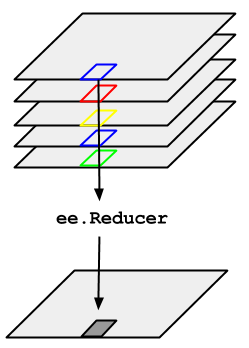
Considere o exemplo de necessidade de calcular a mediana de uma série temporal de imagens
representada por um ImageCollection. Para reduzir um ImageCollection,
use imageCollection.reduce(). Isso reduz a coleção de imagens a uma
imagem individual, conforme ilustrado na Figura 1. Especificamente, a saída é calculada
por pixel, de modo que cada pixel na saída é composto pelo valor mediano de todas as
imagens da coleção naquele local. Para receber outras estatísticas, como média, soma, variância, percentil arbitrário etc., o redutor apropriado precisa ser selecionado e aplicado. Consulte a guia Documentos no
Editor de código para conferir uma lista de todos os redutores
disponíveis no momento. Para estatísticas básicas, como mínimo, máximo, média etc.,
ImageCollection tem métodos de atalho, como min(), max(), mean() etc. Eles funcionam exatamente da mesma maneira
que a chamada reduce(), exceto que os nomes das bandas resultantes não terão o
nome do redutor anexado.
Figura 1. Ilustração de um ee.Reducer aplicado a uma ImageCollection.
Para um exemplo de redução de um ImageCollection, considere uma coleção de imagens do Landsat 5, filtrada por caminho e linha. O código a seguir usa reduce()
para reduzir a coleção a um Image. Aqui, um redutor de mediana é usado apenas
para fins ilustrativos:
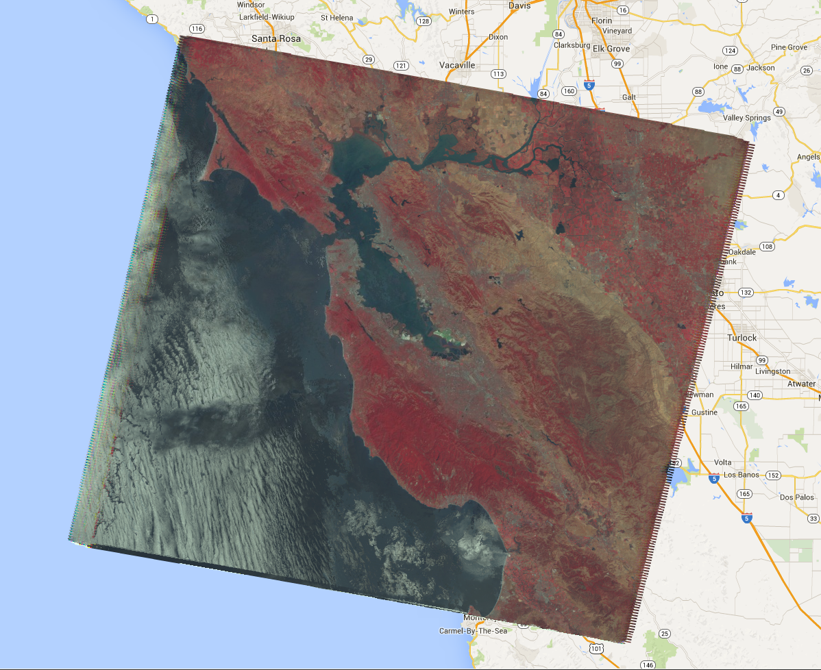
Isso retorna uma Image de várias bandas, em que cada pixel é a mediana de todos
os pixels desmascarados na ImageCollection nesse local. Especificamente,
o redutor foi repetido para cada banda das imagens de entrada, o que significa que a mediana
é calculada de forma independente em cada banda. Os nomes das bandas têm o nome do
redutor anexado: 'B1_median', 'B2_median' etc.
A saída deve ser semelhante à Figura 2.
Para mais informações sobre como reduzir coleções de imagens, consulte a
seção de redução dos documentos do ImageCollection. Em
particular, observe que as imagens produzidas pela redução de um ImageCollectionnão têm projeção. Isso significa
que você precisa definir explicitamente a escala em todas as computações que envolvem a saída de
imagens computadas por uma redução de ImageCollection.
Figura 2. Um composto de falsa cor da mediana das cenas do Landsat 5 em 2008.
[null,null,["Última atualização 2025-07-25 UTC."],[[["\u003cp\u003eUse \u003ccode\u003eimageCollection.reduce()\u003c/code\u003e to reduce an \u003ccode\u003eImageCollection\u003c/code\u003e to a single image by applying a reducer function pixel-wise.\u003c/p\u003e\n"],["\u003cp\u003eEarth Engine provides built-in reducers for common statistics like median, mean, min, max, and more.\u003c/p\u003e\n"],["\u003cp\u003eThe output of \u003ccode\u003ereduce()\u003c/code\u003e is a multi-band image where each pixel represents the reduced value across the input images.\u003c/p\u003e\n"],["\u003cp\u003eBand names in the output image are appended with the reducer name (e.g., \u003ccode\u003eB1_median\u003c/code\u003e).\u003c/p\u003e\n"],["\u003cp\u003eReduced images have no projection, requiring explicit scale setting for further computations.\u003c/p\u003e\n"]]],[],null,["# ImageCollection Reductions\n\nConsider the example of needing to take the median over a time series of images\nrepresented by an `ImageCollection`. To reduce an `ImageCollection`,\nuse `imageCollection.reduce()`. This reduces the collection of images to an\nindividual image as illustrated in Figure 1. Specifically, the output is computed\npixel-wise, such that each pixel in the output is composed of the median value of all the\nimages in the collection at that location. To get other statistics, such as mean, sum,\nvariance, an arbitrary percentile, etc., the appropriate reducer should be selected and\napplied. (See the **Docs** tab in the\n[Code Editor](https://code.earthengine.google.com) for a list of all the reducers\ncurrently available). For basic statistics like min, max, mean, etc.,\n`ImageCollection` has shortcut methods like `min()`,\n`max()`, `mean()`, etc. They function in exactly the same way\nas calling `reduce()`, except the resultant band names will not have the\nname of the reducer appended.\nFigure 1. Illustration of an ee.Reducer applied to an ImageCollection.\n\nFor an example of reducing an `ImageCollection`, consider a collection of\nLandsat 5 images, filtered by path and row. The following code uses `reduce()`\nto reduce the collection to one `Image` (here a median reducer is used simply\nfor illustrative purposes):\n\n### Code Editor (JavaScript)\n\n```javascript\n// Load an image collection, filtered so it's not too much data.\nvar collection = ee.ImageCollection('LANDSAT/LT05/C02/T1')\n .filterDate('2008-01-01', '2008-12-31')\n .filter(ee.Filter.eq('WRS_PATH', 44))\n .filter(ee.Filter.eq('WRS_ROW', 34));\n\n// Compute the median in each band, each pixel.\n// Band names are B1_median, B2_median, etc.\nvar median = collection.reduce(ee.Reducer.median());\n\n// The output is an Image. Add it to the map.\nvar vis_param = {bands: ['B4_median', 'B3_median', 'B2_median'], gamma: 1.6};\nMap.setCenter(-122.3355, 37.7924, 9);\nMap.addLayer(median, vis_param);\n```\nPython setup\n\nSee the [Python Environment](/earth-engine/guides/python_install) page for information on the Python API and using\n`geemap` for interactive development. \n\n```python\nimport ee\nimport geemap.core as geemap\n```\n\n### Colab (Python)\n\n```python\n# Load an image collection, filtered so it's not too much data.\ncollection = (\n ee.ImageCollection('LANDSAT/LT05/C02/T1')\n .filterDate('2008-01-01', '2008-12-31')\n .filter(ee.Filter.eq('WRS_PATH', 44))\n .filter(ee.Filter.eq('WRS_ROW', 34))\n)\n\n# Compute the median in each band, each pixel.\n# Band names are B1_median, B2_median, etc.\nmedian = collection.reduce(ee.Reducer.median())\n\n# The output is an Image. Add it to the map.\nvis_param = {'bands': ['B4_median', 'B3_median', 'B2_median'], 'gamma': 1.6}\nm = geemap.Map()\nm.set_center(-122.3355, 37.7924, 9)\nm.add_layer(median, vis_param)\nm\n```\n\nThis returns a multi-band `Image`, each pixel of which is the median of all\nunmasked pixels in the `ImageCollection` at that pixel location. Specifically,\nthe reducer has been repeated for each band of the input imagery, meaning that the median\nis computed independently in each band. Note that the band names have the name of the\nreducer appended: `'B1_median'`, `'B2_median'`, etc.\nThe output should look something like Figure 2.\n\nFor more information about reducing image collections, see the\n[reducing section of the `ImageCollection` docs](/earth-engine/guides/ic_reducing). In\nparticular, note that images produced by reducing an `ImageCollection`\n[have no projection](/earth-engine/guides/ic_reducing#composites-have-no-projection). This means\nthat you should explicitly set the scale on any computations involving computed images\noutput by an `ImageCollection` reduction.\nFigure 2. A false color composite of the median of Landsat 5 scenes in 2008."]]