Duyuru: 15 Nisan 2025'ten önce Earth Engine'i kullanmak için kaydedilen tüm ticari olmayan projelerin Earth Engine erişimini sürdürmek için ticari olmayan uygunluğu doğrulaması gerekir.
Koleksiyonlar ile düzeninizi koruyun
İçeriği tercihlerinize göre kaydedin ve kategorilere ayırın.
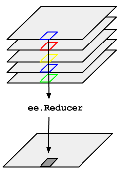
ImageCollection ile temsil edilen bir resim zaman serisi üzerinde medyanı almanız gereken örneği düşünün. ImageCollection değerini azaltmak için imageCollection.reduce() değerini kullanın. Bu işlem, resim koleksiyonunu Şekil 1'de gösterildiği gibi tek bir resme indirger. Daha açık belirtmek gerekirse, çıkış piksel bazında hesaplanır. Böylece, çıkıştaki her piksel, koleksiyondaki tüm resimlerin söz konusu konumdaki medyan değerinden oluşur. Ortalama, toplam, varyans, rastgele yüzdelik dilim vb. gibi diğer istatistikleri elde etmek için uygun azaltıcı seçilmeli ve uygulanmalıdır. (Şu anda kullanılabilen tüm azaltıcıların listesi için Kod Düzenleyici'deki Dokümanlar sekmesine bakın). Minimum, maksimum, ortalama gibi temel istatistikler için
ImageCollection, min(), max(), mean() gibi kısayol yöntemlerine sahiptir. Bu yöntemler, reduce() çağrılmasıyla tamamen aynı şekilde çalışır. Bunun tek istisnası, elde edilen bant adlarına azaltıcının adının eklenmemesidir.
Şekil 1. Bir ImageCollection'a uygulanan ee.Reducer'ı gösteren görsel.
ImageCollection küçültme örneği olarak, yola ve satıra göre filtrelenmiş bir Landsat 5 görüntü koleksiyonu düşünün. Aşağıdaki kod, koleksiyonu bir Image değerine indirmek için reduce() değerini kullanır (burada orta değer azaltıcı, yalnızca açıklama amacıyla kullanılmıştır):
Bu işlem, her pikseli ImageCollection'taki ilgili piksel konumundaki tüm maskesiz piksellerin ortanca değeri olan çok bantlı bir Image döndürür. Daha açık belirtmek gerekirse, azaltıcı, giriş görüntüsünün her bandı için tekrarlanmıştır. Yani medyan her bantta bağımsız olarak hesaplanır. Bant adlarına, azaltıcının adının eklendiğini unutmayın: 'B1_median', 'B2_median' vb.
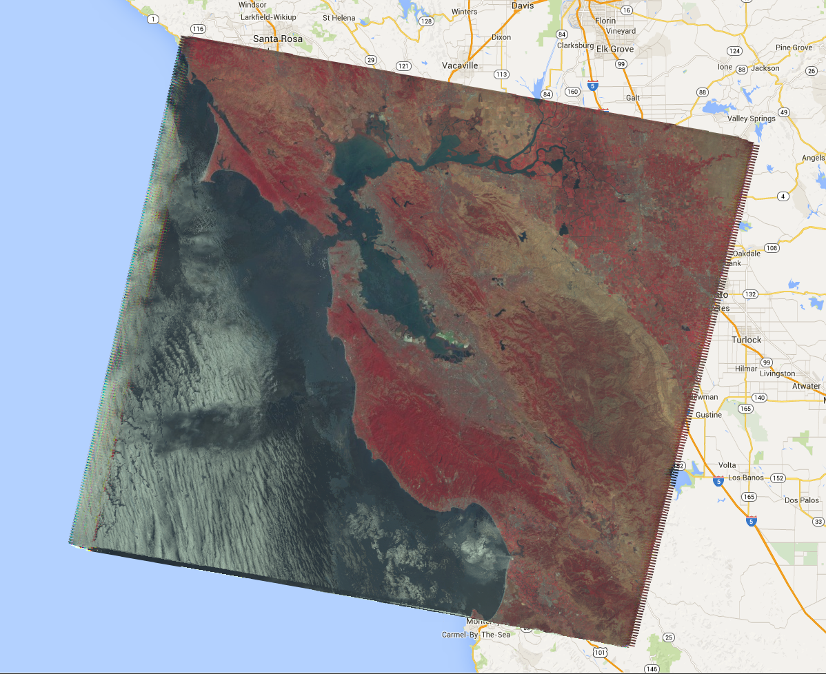
Çıkış, Şekil 2'ye benzer şekilde görünmelidir.
Resim koleksiyonlarını azaltma hakkında daha fazla bilgi için ImageCollection belgelerinin azaltma bölümüne bakın. Özellikle, ImageCollection'nin küçültülmesiyle oluşturulan resimlerin projeksiyon içermediğini unutmayın. Bu, hesaplanan görüntü çıktılarını içeren tüm hesaplamalarda ölçeği ImageCollection azaltarak açıkça ayarlamanız gerektiği anlamına gelir.
Şekil 2. 2008'deki Landsat 5 görüntülerinin medyan değerinin yanlış renk kompozit resmi.
[null,null,["Son güncelleme tarihi: 2025-07-25 UTC."],[[["\u003cp\u003eUse \u003ccode\u003eimageCollection.reduce()\u003c/code\u003e to reduce an \u003ccode\u003eImageCollection\u003c/code\u003e to a single image by applying a reducer function pixel-wise.\u003c/p\u003e\n"],["\u003cp\u003eEarth Engine provides built-in reducers for common statistics like median, mean, min, max, and more.\u003c/p\u003e\n"],["\u003cp\u003eThe output of \u003ccode\u003ereduce()\u003c/code\u003e is a multi-band image where each pixel represents the reduced value across the input images.\u003c/p\u003e\n"],["\u003cp\u003eBand names in the output image are appended with the reducer name (e.g., \u003ccode\u003eB1_median\u003c/code\u003e).\u003c/p\u003e\n"],["\u003cp\u003eReduced images have no projection, requiring explicit scale setting for further computations.\u003c/p\u003e\n"]]],[],null,["# ImageCollection Reductions\n\nConsider the example of needing to take the median over a time series of images\nrepresented by an `ImageCollection`. To reduce an `ImageCollection`,\nuse `imageCollection.reduce()`. This reduces the collection of images to an\nindividual image as illustrated in Figure 1. Specifically, the output is computed\npixel-wise, such that each pixel in the output is composed of the median value of all the\nimages in the collection at that location. To get other statistics, such as mean, sum,\nvariance, an arbitrary percentile, etc., the appropriate reducer should be selected and\napplied. (See the **Docs** tab in the\n[Code Editor](https://code.earthengine.google.com) for a list of all the reducers\ncurrently available). For basic statistics like min, max, mean, etc.,\n`ImageCollection` has shortcut methods like `min()`,\n`max()`, `mean()`, etc. They function in exactly the same way\nas calling `reduce()`, except the resultant band names will not have the\nname of the reducer appended.\nFigure 1. Illustration of an ee.Reducer applied to an ImageCollection.\n\nFor an example of reducing an `ImageCollection`, consider a collection of\nLandsat 5 images, filtered by path and row. The following code uses `reduce()`\nto reduce the collection to one `Image` (here a median reducer is used simply\nfor illustrative purposes):\n\n### Code Editor (JavaScript)\n\n```javascript\n// Load an image collection, filtered so it's not too much data.\nvar collection = ee.ImageCollection('LANDSAT/LT05/C02/T1')\n .filterDate('2008-01-01', '2008-12-31')\n .filter(ee.Filter.eq('WRS_PATH', 44))\n .filter(ee.Filter.eq('WRS_ROW', 34));\n\n// Compute the median in each band, each pixel.\n// Band names are B1_median, B2_median, etc.\nvar median = collection.reduce(ee.Reducer.median());\n\n// The output is an Image. Add it to the map.\nvar vis_param = {bands: ['B4_median', 'B3_median', 'B2_median'], gamma: 1.6};\nMap.setCenter(-122.3355, 37.7924, 9);\nMap.addLayer(median, vis_param);\n```\nPython setup\n\nSee the [Python Environment](/earth-engine/guides/python_install) page for information on the Python API and using\n`geemap` for interactive development. \n\n```python\nimport ee\nimport geemap.core as geemap\n```\n\n### Colab (Python)\n\n```python\n# Load an image collection, filtered so it's not too much data.\ncollection = (\n ee.ImageCollection('LANDSAT/LT05/C02/T1')\n .filterDate('2008-01-01', '2008-12-31')\n .filter(ee.Filter.eq('WRS_PATH', 44))\n .filter(ee.Filter.eq('WRS_ROW', 34))\n)\n\n# Compute the median in each band, each pixel.\n# Band names are B1_median, B2_median, etc.\nmedian = collection.reduce(ee.Reducer.median())\n\n# The output is an Image. Add it to the map.\nvis_param = {'bands': ['B4_median', 'B3_median', 'B2_median'], 'gamma': 1.6}\nm = geemap.Map()\nm.set_center(-122.3355, 37.7924, 9)\nm.add_layer(median, vis_param)\nm\n```\n\nThis returns a multi-band `Image`, each pixel of which is the median of all\nunmasked pixels in the `ImageCollection` at that pixel location. Specifically,\nthe reducer has been repeated for each band of the input imagery, meaning that the median\nis computed independently in each band. Note that the band names have the name of the\nreducer appended: `'B1_median'`, `'B2_median'`, etc.\nThe output should look something like Figure 2.\n\nFor more information about reducing image collections, see the\n[reducing section of the `ImageCollection` docs](/earth-engine/guides/ic_reducing). In\nparticular, note that images produced by reducing an `ImageCollection`\n[have no projection](/earth-engine/guides/ic_reducing#composites-have-no-projection). This means\nthat you should explicitly set the scale on any computations involving computed images\noutput by an `ImageCollection` reduction.\nFigure 2. A false color composite of the median of Landsat 5 scenes in 2008."]]