Earth Engine에서 벡터-래스터 변환은 featureCollection.reduceToImage() 메서드로 처리됩니다. 이 메서드는 각 지형지물 아래의 픽셀에 지정된 속성의 값을 할당합니다. 이 예에서는 카운티 데이터를 사용하여 각 카운티의 면적을 나타내는 이미지를 만듭니다.
코드 편집기 (JavaScript)
// Load a collection of US counties.
var counties = ee.FeatureCollection('TIGER/2018/Counties');

// Make an image out of the land area attribute.
var landAreaImg = counties
  .filter(ee.Filter.notNull(['ALAND']))
  .reduceToImage({
    properties: ['ALAND'],
    reducer: ee.Reducer.first()
});

// Display the county land area image.
Map.setCenter(-99.976, 40.38, 5);
Map.addLayer(landAreaImg, {
  min: 3e8,
  max: 1.5e10,
  palette: ['FCFDBF', 'FDAE78', 'EE605E', 'B63679', '711F81', '2C105C']
});
import ee
import geemap.core as geemap
Colab (Python)
# Load a collection of US counties.
counties = ee.FeatureCollection('TIGER/2018/Counties')

# Make an image out of the land area attribute.
land_area_img = counties.filter(ee.Filter.notNull(['ALAND'])).reduceToImage(
    properties=['ALAND'], reducer=ee.Reducer.first()
)

# Display the county land area image.
m = geemap.Map()
m.set_center(-99.976, 40.38, 5)
m.add_layer(
    land_area_img,
    {
        'min': 3e8,
        'max': 1.5e10,
        'palette': ['FCFDBF', 'FDAE78', 'EE605E', 'B63679', '711F81', '2C105C'],
    },
)
m
중복된 지형지물의 속성을 집계하는 방법을 나타내는 감소기를 지정합니다. 이전 예에서는 겹치는 부분이 없으므로 ee.Reducer.first()으로 충분합니다. 이 예와 같이 데이터를 사전 필터링하여 이미지로 변환할 수 없는 null을 제거합니다.
출력은 색상 그라데이션을 카운티 크기에 매핑하는 그림 1과 같이 표시됩니다. Earth Engine의 모든 이미지 출력 리듀서와 마찬가지로, 크기는 출력에 의해 동적으로 설정됩니다. 이 경우 크기는 코드 편집기의 확대/축소 수준에 해당합니다.
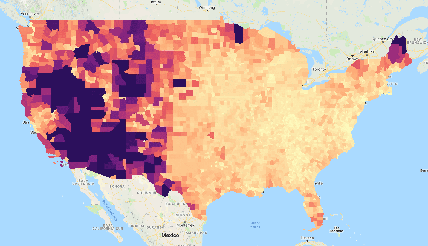
reduceToImage()가 'TIGER/2018/Counties' FeatureCollection의 'ALAND'(토지 면적) 속성을 사용한 결과입니다.