Sprawdzanie brakujących obrazów w katalogu danych
Zadbaj o dobrą organizację dzięki kolekcji
Zapisuj i kategoryzuj treści zgodnie ze swoimi preferencjami.
Celem tego dokumentu jest pomoc w określeniu, czy w Earth Engine Data Catalog (obecnie Landsat, Sentinel i MODIS) brakuje jakiegoś zasobu.
Poniżej znajdziesz instrukcje, jak:
Najczęstsze kwestie do rozważenia
Poziom przetwarzania: w przypadku danego poziomu przetwarzania lub produktu mogą nie być dostępne wszystkie obrazy. Na przykład obrazy o niskiej jakości mogą nie zostać przetworzone na najwyższym poziomie.
Pokrycie czasowo-przestrzenne: regularna częstotliwość nie jest gwarantowana w przypadku każdego zbioru danych. Różnice w zadaniach wykonywanych przez czujniki, jakości obrazu i zarządzaniu archiwum mogą wpływać na dostępność danych dostawcy.
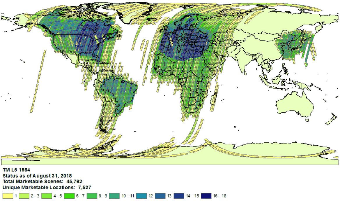
Przykład zasięgu zbioru Landsat 5 w 1984 r.
- Wybór dostawcy: dane są przetwarzane w Earth Engine Data Catalog z wybranego dostawcy na podstawie zbioru danych. Możliwe, że dostawca nie oferuje pełnej archiwum misji. Na przykład zbiory danych Landsat są przetwarzane z archiwum USGS, w którym brakuje zdjęć z określonych stacji odbiorczych w określonych przedziałach czasu (więcej informacji znajdziesz w inicjatywie LGAC).
Landsat
Dane Landsat są przetwarzane z USGS.
Sprawdź dostępność danych Landsat w wybranym czasie i miejscu.
Przeprowadź wyszukiwanie w Earth Engine, aby uzyskać listę wszystkich zasobów dla wybranego czasu i obszaru. Upewnij się, że w Twoim kodzie nie zostały przypadkowo odfiltrowane żadne zasoby.
Oto przykładowy skrypt. Pamiętaj, aby importować kolekcję z odpowiednim poziomem przetwarzania i poziomem (dowiedz się więcej o strukturze kolekcji Landsat).
Sprawdź, czy w katalogu USGS Earth Explorer nie brakuje Ci zasobów (szczegółowe instrukcje dotyczące wyszukiwania i wybierania zbiorów danych znajdziesz w przewodniku pomocy).
Upewnij się, że porównujesz odpowiednie produkty i poziomy przetwarzania (zobacz strukturę kolekcji Landsat).
Pamiętaj, że produkty dotyczące odbicia powierzchni są generowane tylko w przypadku obrazów Landsat na poziomie przetwarzania L1TP.
Udostępnij szczegółowe dowody braku zasobów, przesyłając formularz z identyfikatorem produktu dostawcy i linkiem do skryptu Earth Engine Code Editor potwierdzającym brak zasobów.
Sentinel
Dane Sentinela są przetwarzane z witryny Copernicus Dataspace.
Sprawdź dostępność danych Sentinela w określonym czasie i miejscu (patrz szczegóły misji).
Uwaga: produkty Sentinel-2 na poziomie 2A są systematycznie generowane w segmentach naziemnych w Europie od marca 2018 r., a w grudniu 2018 r. ich produkcja została rozszerzona na cały świat (więcej informacji znajdziesz w przewodniku użytkownika ESA).
Ostatecznie zostaną one ponownie wygenerowane w ramach kolekcji 1.
Przeprowadź wyszukiwanie w Earth Engine, aby uzyskać listę wszystkich zasobów dla wybranego czasu i obszaru. Upewnij się, że w Twoim kodzie nie zostały przypadkowo odfiltrowane żadne zasoby. Oto przykładowy skrypt. Pamiętaj, aby importować kolekcję z odpowiednim poziomem przetwarzania.
Sprawdź, czy w katalogu Copernicus nie brakuje jakichś zasobów.
Udostępnij szczegółowe dowody braku zasobów, przesyłając formularz z identyfikatorem produktu dostawcy i linkiem do skryptu Earth Engine Code Editor potwierdzającym brak zasobów.
MODIS
Dane MODIS są pozyskiwane z Land Processes Distributed Active Archive Center (LP DAAC).
Przeprowadź wyszukiwanie w Earth Engine, aby uzyskać listę wszystkich zasobów dla wybranego czasu i obszaru. Upewnij się, że w Twoim kodzie nie zostały przypadkowo odfiltrowane żadne zasoby. Oto przykładowy skrypt. Upewnij się, że importujesz właściwy produkt.
Sprawdź, czy w zbiorze danych USGS nie brakuje zasobów, które nie zostały dodane do Earth Engine. Przejdź do odpowiedniego folderu i sprawdź, jakie najnowsze katalogi są dostępne.
Zbiory danych zaczynające się od „MOD” znajdują się w folderze „Terra MODIS”.
Zbiory danych zaczynające się od „MYD” znajdują się w folderze „Aqua MODIS”.
Zbiory danych rozpoczynające się od „MCD” znajdują się w folderze „Combined MODIS”.
Zbiory danych rozpoczynające się od „VNP” znajdują się w folderze „S-NPP VIIRS”.
Udostępnij szczegółowe dowody braku zasobów, przesyłając formularz z identyfikatorem produktu dostawcy i linkiem do skryptu Earth Engine Code Editor potwierdzającym brak zasobów.
O ile nie stwierdzono inaczej, treść tej strony jest objęta licencją Creative Commons – uznanie autorstwa 4.0, a fragmenty kodu są dostępne na licencji Apache 2.0. Szczegółowe informacje na ten temat zawierają zasady dotyczące witryny Google Developers. Java jest zastrzeżonym znakiem towarowym firmy Oracle i jej podmiotów stowarzyszonych.
Ostatnia aktualizacja: 2025-07-25 UTC.
[null,null,["Ostatnia aktualizacja: 2025-07-25 UTC."],[[["\u003cp\u003eThis document provides guidance to determine if a Landsat, Sentinel, or MODIS asset is missing from the Earth Engine Data Catalog.\u003c/p\u003e\n"],["\u003cp\u003eUsers can verify potential missing assets by checking the provider's catalog and comparing it against the Earth Engine catalog.\u003c/p\u003e\n"],["\u003cp\u003eDetailed information, including the provider's product ID and an Earth Engine script, must be submitted when reporting missing assets.\u003c/p\u003e\n"],["\u003cp\u003eVariances in data availability may occur due to factors like processing levels, spatiotemporal coverage, and provider data archives.\u003c/p\u003e\n"]]],["To find missing assets in the Earth Engine Data Catalog, first, check provider catalogs (USGS, Copernicus, or LP DAAC) for coverage availability. Next, search Earth Engine, ensuring no filters exclude assets. Compare results to the provider's catalog. For Landsat, use USGS Earth Explorer; for Sentinel, use the Copernicus catalog; and for MODIS, use the USGS Data Pool. Finally, report any discrepancies to the Earth Engine team via a ticket, including the provider's product ID and an Earth Engine script link.\n"],null,["# Verify Missing Images in the Data Catalog\n\nThe purpose of this document is to help you determine if an asset is missing\nin the Earth Engine Data Catalog (currently Landsat, Sentinel, and MODIS).\n\nThe steps outlined describe how to:\n\n- Check for available assets in Earth Engine's and providers' catalogs.\n\n- Collect information needed to submit confirmation of a missing\n asset to the Earth Engine data team.\n\nCommon things to consider\n-------------------------\n\n- **Processing level**: not all images may be available for a given processing\n level or product. For instance, low-quality images may not be processed\n to the highest level.\n\n- **Spatiotemporal coverage**: a regular cadence is not\n guaranteed for each dataset. Variation in sensor tasking, image quality,\n and archive management can affect provider data availability.\n\n\nExample of Landsat 5\n[collection coverage](https://landsat.usgs.gov/usgs-landsat-global-archive) for\n1984.\n\n- **Provider choice** : data are ingested into the Earth Engine Data Catalog from a selected provider per dataset. It is possible that the provider does not offer a complete mission archive. For example, Landsat datasets are ingested from the USGS archive, which is known to be missing imagery from certain receiving stations for certain periods of time (see the [LGAC effort](https://www.usgs.gov/land-resources/nli/landsat/landsat-global-archive-consolidation?qt-science_support_page_related_con=3#qt-science_support_page_related_con) for more information).\n\nLandsat\n-------\n\nLandsat data are ingested from the\n[U.S. Geological Survey](https://www.usgs.gov/land-resources/nli/landsat)\n(USGS).\n\n1. Confirm\n [Landsat coverage availability](https://landsat.usgs.gov/usgs-landsat-global-archive)\n for the time and area of interest.\n\n2. Perform a search in Earth Engine to get a list of all assets for the time and\n area of interest. Take care to ensure no assets have been accidentally\n filtered out within your code.\n Here is an [example script](https://code.earthengine.google.com/975bff3a2ff955e5f884005b5dd2bafb);\n be sure you are importing the collection with the right tier and processing\n level (learn more\n [about the Landsat collection structure](https://developers.google.com/earth-engine/landsat#landsat-collection-structure)).\n\n3. Look for potentially missing assets in the\n [USGS Earth Explorer](https://earthexplorer.usgs.gov/) catalog (see the help\n guide for detailed steps on\n [performing a search](https://lta.cr.usgs.gov/EEHelp/ee_tutorial_search_criteria)\n and [selecting datasets](https://lta.cr.usgs.gov/EEHelp/ee_tutorial_search_datasets)).\n Make sure you are comparing the right products and processing levels\n ([see Landsat collection structure](https://developers.google.com/earth-engine/landsat#landsat-collection-structure)).\n Note that surface reflectance products are only generated for Landsat images with\n processing level\n [L1TP](https://www.usgs.gov/land-resources/nli/landsat/landsat-levels-processing).\n\n4. Share detailed evidence of missing assets by submitting a\n [ticket](https://issuetracker.google.com/issues/new?component=184406&template=1254745)\n with the provider's product ID and a\n [link](https://developers.google.com/earth-engine/playground#get-link)\n to an Earth Engine Code Editor script confirming the absence of the assets.\n\nSentinel\n--------\n\nSentinel data are ingested from the\n[Copernicus Dataspace site](https://dataspace.copernicus.eu/).\n\n1. Confirm\n Sentinel coverage availability for the time and area of interest (see\n [mission details](https://sentinel.esa.int/web/sentinel/missions)).\n\n *Note* : Sentinel-2 Level-2A products are systematically generated at the\n ground segment over Europe only since March 2018, and the production\n was extended to global in December 2018 (see\n [ESA User Guide](https://sentinel.esa.int/web/sentinel/user-guides/sentinel-2-msi)\n for more details).\n They will eventually be regenerated as a part of Collection 1.\n2. Perform a search in Earth Engine to get a list of all assets for the time and\n area of interest. Take care to ensure no assets have been accidentally\n filtered out within your code. Here is an\n [example script](https://code.earthengine.google.com/4bebc6b8b44807a2001bc34d49fc25eb);\n be sure you are importing the collection with the right processing\n level.\n\n3. Look for potentially missing assets in the\n [Copernicus catalog](https://dataspace.copernicus.eu/browser/).\n\n4. Share detailed evidence of missing assets by submitting a\n [ticket](https://issuetracker.google.com/issues/new?component=184406&template=1254745)\n with the provider's product ID and a\n [link](https://developers.google.com/earth-engine/playground#get-link)\n to an Earth Engine Code Editor script confirming the absence of the assets.\n\nMODIS\n-----\n\nMODIS data are ingested from the\n[Land Processes Distributed Active Archive Center](https://lpdaac.usgs.gov/)\n(LP DAAC).\n\n1. Perform a search in Earth Engine to get a list of all assets for the time and\n area of interest. Take care to ensure no assets have been accidentally\n filtered out within your code. Here is an\n [example script](https://code.earthengine.google.com/848200c362694900b6027b30b0e99677);\n be sure you are importing the intended product.\n\n2. Look for potentially missing assets in the\n [USGS Data Pool](https://lpdaac.usgs.gov/tools/data-pool/) that have not been\n added to Earth Engine. Navigate to the appropriate folder and identify the\n latest directories available.\n\n - Datasets starting with \"MOD\" are in\n \"[Terra MODIS](https://e4ftl01.cr.usgs.gov/MOLT/)\"\n\n - Datasets starting with \"MYD\" are in\n \"[Aqua MODIS](https://e4ftl01.cr.usgs.gov/MOLA/)\"\n\n - Datasets starting with \"MCD\" are in\n \"[Combined MODIS](https://e4ftl01.cr.usgs.gov/MOTA/)\"\n\n - Datasets starting with \"VNP\" are in\n \"[S-NPP VIIRS](https://e4ftl01.cr.usgs.gov/VIIRS/)\"\n\n3. Share detailed evidence of missing assets by submitting a\n [ticket](https://issuetracker.google.com/issues/new?component=184406&template=1254745)\n with the provider's product ID and a\n [link](https://developers.google.com/earth-engine/playground#get-link)\n to an Earth Engine Code Editor script confirming the absence of the assets."]]