ยืนยันรูปภาพที่หายไปในแคตตาล็อกข้อมูล
จัดทุกอย่างให้เป็นระเบียบอยู่เสมอด้วยคอลเล็กชัน
บันทึกและจัดหมวดหมู่เนื้อหาตามค่ากำหนดของคุณ
เอกสารนี้มีไว้เพื่อช่วยคุณระบุว่ามีชิ้นงานขาดหายไปหรือไม่ในแคตตาล็อกข้อมูล Earth Engine (ปัจจุบันคือ Landsat, Sentinel และ MODIS)
ขั้นตอนที่ระบุไว้จะอธิบายวิธีดำเนินการต่อไปนี้
สิ่งที่ควรพิจารณาโดยทั่วไป
ระดับการประมวลผล: รูปภาพบางรูปอาจไม่พร้อมใช้งานสำหรับระดับการประมวลผลหรือผลิตภัณฑ์หนึ่งๆ เช่น ระบบอาจไม่ประมวลผลรูปภาพคุณภาพต่ำเป็นระดับสูงสุด
ความครอบคลุมเชิงพื้นที่และเวลา: ไม่มีการรับประกันความถี่ที่แน่นอนสำหรับชุดข้อมูลแต่ละชุด ความแตกต่างของงานเซ็นเซอร์ คุณภาพของรูปภาพ และการจัดการที่เก็บถาวรอาจส่งผลต่อความพร้อมใช้งานของข้อมูลผู้ให้บริการ
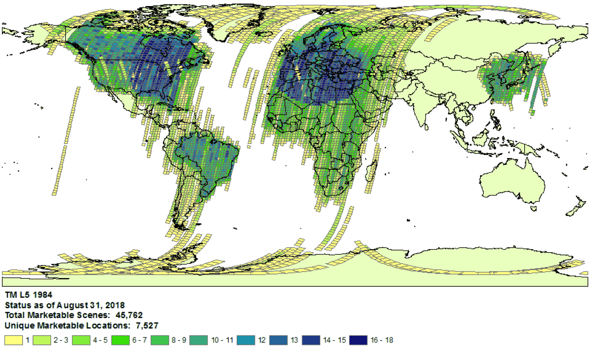
ตัวอย่างความครอบคลุมของชุดข้อมูล Landsat 5 เมื่อปี 1984
- ตัวเลือกผู้ให้บริการ: ระบบจะนำเข้าข้อมูลจากผู้ให้บริการที่เลือกไว้ในแต่ละชุดข้อมูลไปยังแคตตาล็อกข้อมูล Earth Engine เป็นไปได้ว่าผู้ให้บริการอาจไม่มีบันทึกภารกิจที่สมบูรณ์ ตัวอย่างเช่น ระบบจะนำเข้าชุดข้อมูล Landsat จากที่เก็บถาวรของ USGS ซึ่งทราบว่าไม่มีภาพจากสถานีรับสัญญาณบางแห่งเป็นระยะเวลาหนึ่ง (ดูข้อมูลเพิ่มเติมจากความพยายามของ LGAC)
Landsat
ระบบจะนำเข้าข้อมูลจาก กรมสำรวจธรณีวิทยาของสหรัฐอเมริกา (USGS)
ตรวจสอบความพร้อมให้บริการของภาพ Landsat สำหรับเวลาและพื้นที่ที่ต้องการ
ทำการค้นหาใน Earth Engine เพื่อดูรายการชิ้นงานทั้งหมดสำหรับเวลาและพื้นที่ที่ต้องการ โปรดตรวจสอบว่าไม่มีชิ้นงานที่กรองออกโดยไม่ตั้งใจภายในโค้ด
สคริปต์ตัวอย่างมีดังนี้ ตรวจสอบว่าคุณกำลังนำเข้าคอลเล็กชันที่มีระดับและการประมวลผลที่เหมาะสม (ดูข้อมูลเพิ่มเติมเกี่ยวกับโครงสร้างคอลเล็กชัน Landsat)
มองหาชิ้นงานที่อาจหายไปในแคตตาล็อก USGS Earth Explorer (ดูคำแนะนำในความช่วยเหลือเพื่อดูขั้นตอนโดยละเอียดเกี่ยวกับการค้นหาและการเลือกชุดข้อมูล)
ตรวจสอบว่าคุณกำลังเปรียบเทียบผลิตภัณฑ์และระดับการประมวลผลที่ถูกต้อง (ดูโครงสร้างคอลเล็กชัน Landsat)
โปรดทราบว่าระบบจะสร้างผลิตภัณฑ์การสะท้อนแสงของพื้นผิวสำหรับภาพ Landsat ที่มีระดับการประมวลผลเป็น L1TP เท่านั้น
แชร์หลักฐานโดยละเอียดเกี่ยวกับชิ้นงานที่หายไปโดยส่งคำขอแจ้งปัญหาพร้อมรหัสผลิตภัณฑ์ของผู้ให้บริการและลิงก์ไปยังสคริปต์เครื่องมือแก้ไขโค้ดของ Earth Engine ที่ยืนยันว่าไม่มีชิ้นงาน
Sentinel
ระบบจะนำเข้าข้อมูลจาก Sentinel จากเว็บไซต์ Copernicus Dataspace
ตรวจสอบความพร้อมให้บริการของ Sentinel สำหรับช่วงเวลาและพื้นที่ที่ต้องการ (ดูรายละเอียดภารกิจ)
หมายเหตุ: ผลิตภัณฑ์ Sentinel-2 ระดับ 2A สร้างขึ้นอย่างเป็นระบบที่ภาคพื้นดินในยุโรปตั้งแต่เดือนมีนาคม 2018 เท่านั้น และขยายการผลิตไปยังทั่วโลกในเดือนธันวาคม 2018 (ดูรายละเอียดเพิ่มเติมได้ที่คู่มือผู้ใช้ ESA)
รายการเหล่านี้จะสร้างขึ้นใหม่โดยเป็นส่วนหนึ่งของคอลเล็กชัน 1 ในท้ายที่สุด
ทำการค้นหาใน Earth Engine เพื่อดูรายการชิ้นงานทั้งหมดสำหรับเวลาและพื้นที่ที่ต้องการ โปรดตรวจสอบว่าไม่มีชิ้นงานที่กรองออกโดยไม่ตั้งใจภายในโค้ด ต่อไปนี้เป็นตัวอย่างสคริปต์ โปรดตรวจสอบว่าคุณนําเข้าคอลเล็กชันด้วยระดับการประมวลผลที่ถูกต้อง
มองหาเนื้อหาที่อาจหายไปในแคตตาล็อก Copernicus
แชร์หลักฐานโดยละเอียดเกี่ยวกับชิ้นงานที่หายไปโดยส่งคำขอแจ้งปัญหาพร้อมรหัสผลิตภัณฑ์ของผู้ให้บริการและลิงก์ไปยังสคริปต์เครื่องมือแก้ไขโค้ดของ Earth Engine ที่ยืนยันว่าไม่มีชิ้นงาน
MODIS
ระบบจะนำเข้าข้อมูลจาก Land Processes Distributed Active Archive Center (LP DAAC)
ทำการค้นหาใน Earth Engine เพื่อดูรายการชิ้นงานทั้งหมดสำหรับเวลาและพื้นที่ที่ต้องการ โปรดตรวจสอบว่าไม่มีชิ้นงานที่กรองออกโดยไม่ตั้งใจภายในโค้ด ต่อไปนี้คือตัวอย่างสคริปต์ โปรดตรวจสอบว่าคุณกำลังนำเข้าผลิตภัณฑ์ที่ต้องการ
มองหาชิ้นงานที่อาจหายไปในกลุ่มข้อมูล USGS ซึ่งยังไม่ได้เพิ่มลงใน Earth Engine ไปที่โฟลเดอร์ที่เหมาะสมและระบุไดเรกทอรีล่าสุดที่ใช้ได้
แชร์หลักฐานโดยละเอียดเกี่ยวกับชิ้นงานที่หายไปโดยส่งคำขอแจ้งปัญหาพร้อมรหัสผลิตภัณฑ์ของผู้ให้บริการและลิงก์ไปยังสคริปต์เครื่องมือแก้ไขโค้ดของ Earth Engine ที่ยืนยันว่าไม่มีชิ้นงาน
เนื้อหาของหน้าเว็บนี้ได้รับอนุญาตภายใต้ใบอนุญาตที่ต้องระบุที่มาของครีเอทีฟคอมมอนส์ 4.0 และตัวอย่างโค้ดได้รับอนุญาตภายใต้ใบอนุญาต Apache 2.0 เว้นแต่จะระบุไว้เป็นอย่างอื่น โปรดดูรายละเอียดที่นโยบายเว็บไซต์ Google Developers Java เป็นเครื่องหมายการค้าจดทะเบียนของ Oracle และ/หรือบริษัทในเครือ
อัปเดตล่าสุด 2025-07-25 UTC
[null,null,["อัปเดตล่าสุด 2025-07-25 UTC"],[[["\u003cp\u003eThis document provides guidance to determine if a Landsat, Sentinel, or MODIS asset is missing from the Earth Engine Data Catalog.\u003c/p\u003e\n"],["\u003cp\u003eUsers can verify potential missing assets by checking the provider's catalog and comparing it against the Earth Engine catalog.\u003c/p\u003e\n"],["\u003cp\u003eDetailed information, including the provider's product ID and an Earth Engine script, must be submitted when reporting missing assets.\u003c/p\u003e\n"],["\u003cp\u003eVariances in data availability may occur due to factors like processing levels, spatiotemporal coverage, and provider data archives.\u003c/p\u003e\n"]]],["To find missing assets in the Earth Engine Data Catalog, first, check provider catalogs (USGS, Copernicus, or LP DAAC) for coverage availability. Next, search Earth Engine, ensuring no filters exclude assets. Compare results to the provider's catalog. For Landsat, use USGS Earth Explorer; for Sentinel, use the Copernicus catalog; and for MODIS, use the USGS Data Pool. Finally, report any discrepancies to the Earth Engine team via a ticket, including the provider's product ID and an Earth Engine script link.\n"],null,["# Verify Missing Images in the Data Catalog\n\nThe purpose of this document is to help you determine if an asset is missing\nin the Earth Engine Data Catalog (currently Landsat, Sentinel, and MODIS).\n\nThe steps outlined describe how to:\n\n- Check for available assets in Earth Engine's and providers' catalogs.\n\n- Collect information needed to submit confirmation of a missing\n asset to the Earth Engine data team.\n\nCommon things to consider\n-------------------------\n\n- **Processing level**: not all images may be available for a given processing\n level or product. For instance, low-quality images may not be processed\n to the highest level.\n\n- **Spatiotemporal coverage**: a regular cadence is not\n guaranteed for each dataset. Variation in sensor tasking, image quality,\n and archive management can affect provider data availability.\n\n\nExample of Landsat 5\n[collection coverage](https://landsat.usgs.gov/usgs-landsat-global-archive) for\n1984.\n\n- **Provider choice** : data are ingested into the Earth Engine Data Catalog from a selected provider per dataset. It is possible that the provider does not offer a complete mission archive. For example, Landsat datasets are ingested from the USGS archive, which is known to be missing imagery from certain receiving stations for certain periods of time (see the [LGAC effort](https://www.usgs.gov/land-resources/nli/landsat/landsat-global-archive-consolidation?qt-science_support_page_related_con=3#qt-science_support_page_related_con) for more information).\n\nLandsat\n-------\n\nLandsat data are ingested from the\n[U.S. Geological Survey](https://www.usgs.gov/land-resources/nli/landsat)\n(USGS).\n\n1. Confirm\n [Landsat coverage availability](https://landsat.usgs.gov/usgs-landsat-global-archive)\n for the time and area of interest.\n\n2. Perform a search in Earth Engine to get a list of all assets for the time and\n area of interest. Take care to ensure no assets have been accidentally\n filtered out within your code.\n Here is an [example script](https://code.earthengine.google.com/975bff3a2ff955e5f884005b5dd2bafb);\n be sure you are importing the collection with the right tier and processing\n level (learn more\n [about the Landsat collection structure](https://developers.google.com/earth-engine/landsat#landsat-collection-structure)).\n\n3. Look for potentially missing assets in the\n [USGS Earth Explorer](https://earthexplorer.usgs.gov/) catalog (see the help\n guide for detailed steps on\n [performing a search](https://lta.cr.usgs.gov/EEHelp/ee_tutorial_search_criteria)\n and [selecting datasets](https://lta.cr.usgs.gov/EEHelp/ee_tutorial_search_datasets)).\n Make sure you are comparing the right products and processing levels\n ([see Landsat collection structure](https://developers.google.com/earth-engine/landsat#landsat-collection-structure)).\n Note that surface reflectance products are only generated for Landsat images with\n processing level\n [L1TP](https://www.usgs.gov/land-resources/nli/landsat/landsat-levels-processing).\n\n4. Share detailed evidence of missing assets by submitting a\n [ticket](https://issuetracker.google.com/issues/new?component=184406&template=1254745)\n with the provider's product ID and a\n [link](https://developers.google.com/earth-engine/playground#get-link)\n to an Earth Engine Code Editor script confirming the absence of the assets.\n\nSentinel\n--------\n\nSentinel data are ingested from the\n[Copernicus Dataspace site](https://dataspace.copernicus.eu/).\n\n1. Confirm\n Sentinel coverage availability for the time and area of interest (see\n [mission details](https://sentinel.esa.int/web/sentinel/missions)).\n\n *Note* : Sentinel-2 Level-2A products are systematically generated at the\n ground segment over Europe only since March 2018, and the production\n was extended to global in December 2018 (see\n [ESA User Guide](https://sentinel.esa.int/web/sentinel/user-guides/sentinel-2-msi)\n for more details).\n They will eventually be regenerated as a part of Collection 1.\n2. Perform a search in Earth Engine to get a list of all assets for the time and\n area of interest. Take care to ensure no assets have been accidentally\n filtered out within your code. Here is an\n [example script](https://code.earthengine.google.com/4bebc6b8b44807a2001bc34d49fc25eb);\n be sure you are importing the collection with the right processing\n level.\n\n3. Look for potentially missing assets in the\n [Copernicus catalog](https://dataspace.copernicus.eu/browser/).\n\n4. Share detailed evidence of missing assets by submitting a\n [ticket](https://issuetracker.google.com/issues/new?component=184406&template=1254745)\n with the provider's product ID and a\n [link](https://developers.google.com/earth-engine/playground#get-link)\n to an Earth Engine Code Editor script confirming the absence of the assets.\n\nMODIS\n-----\n\nMODIS data are ingested from the\n[Land Processes Distributed Active Archive Center](https://lpdaac.usgs.gov/)\n(LP DAAC).\n\n1. Perform a search in Earth Engine to get a list of all assets for the time and\n area of interest. Take care to ensure no assets have been accidentally\n filtered out within your code. Here is an\n [example script](https://code.earthengine.google.com/848200c362694900b6027b30b0e99677);\n be sure you are importing the intended product.\n\n2. Look for potentially missing assets in the\n [USGS Data Pool](https://lpdaac.usgs.gov/tools/data-pool/) that have not been\n added to Earth Engine. Navigate to the appropriate folder and identify the\n latest directories available.\n\n - Datasets starting with \"MOD\" are in\n \"[Terra MODIS](https://e4ftl01.cr.usgs.gov/MOLT/)\"\n\n - Datasets starting with \"MYD\" are in\n \"[Aqua MODIS](https://e4ftl01.cr.usgs.gov/MOLA/)\"\n\n - Datasets starting with \"MCD\" are in\n \"[Combined MODIS](https://e4ftl01.cr.usgs.gov/MOTA/)\"\n\n - Datasets starting with \"VNP\" are in\n \"[S-NPP VIIRS](https://e4ftl01.cr.usgs.gov/VIIRS/)\"\n\n3. Share detailed evidence of missing assets by submitting a\n [ticket](https://issuetracker.google.com/issues/new?component=184406&template=1254745)\n with the provider's product ID and a\n [link](https://developers.google.com/earth-engine/playground#get-link)\n to an Earth Engine Code Editor script confirming the absence of the assets."]]