Zbiory można złączać według lokalizacji przestrzennej i według wartości właściwości. Aby złączać dane na podstawie lokalizacji przestrzennej, użyj filtra withinDistance() z określonymi polami złączenia .geo. Pole .geo wskazuje, że do obliczenia odległości ma być użyta geometria elementu. Załóżmy na przykład, że chcesz znaleźć wszystkie W tym celu użyj filtra w polach geometrycznych, ustawiając maksymalną odległość na 100 km za pomocą parametru distance:
Edytor kodu (JavaScript)
// Load a primary collection: protected areas (Yosemite National Park).
var primary = ee.FeatureCollection("WCMC/WDPA/current/polygons")
  .filter(ee.Filter.eq('NAME', 'Yosemite National Park'));

// Load a secondary collection: power plants.
var powerPlants = ee.FeatureCollection('WRI/GPPD/power_plants');

// Define a spatial filter, with distance 100 km.
var distFilter = ee.Filter.withinDistance({
  distance: 100000,
  leftField: '.geo',
  rightField: '.geo',
  maxError: 10
});

// Define a saveAll join.
var distSaveAll = ee.Join.saveAll({
  matchesKey: 'points',
  measureKey: 'distance'
});

// Apply the join.
var spatialJoined = distSaveAll.apply(primary, powerPlants, distFilter);

// Print the result.
print(spatialJoined);
import ee
import geemap.core as geemap
Colab (Python)
# Load a primary collection: protected areas (Yosemite National Park).
primary = ee.FeatureCollection('WCMC/WDPA/current/polygons').filter(
    ee.Filter.eq('NAME', 'Yosemite National Park')
)

# Load a secondary collection: power plants.
power_plants = ee.FeatureCollection('WRI/GPPD/power_plants')

# Define a spatial filter, with distance 100 km.
dist_filter = ee.Filter.withinDistance(
    distance=100000, leftField='.geo', rightField='.geo', maxError=10
)

# Define a saveAll join.
dist_save_all = ee.Join.saveAll(matchesKey='points', measureKey='distance')

# Apply the join.
spatial_joined = dist_save_all.apply(primary, power_plants, dist_filter)

# Print the result.
display(spatial_joined)
W poprzednim przykładzie tabela FeatureCollection jest złączana z inną tabelą FeatureCollection. Operacja złączenia saveAll() ustawia w przypadku każdego elementu w kolekcji primary właściwość points, która przechowuje listę punktów w odległości do 100 km od tego elementu. Odległość każdego punktu od funkcji jest przechowywana w właściwości distance każdego złączonego punktu.
Złączenia przestrzenne można też stosować do określania, które cechy w jednej kolekcji pokrywają się z cechami w innej. Rozważmy na przykład 2 zbiory obiektów: zbiór primary zawierający wielokąty przedstawiające granice stanów w USA oraz zbiór secondary zawierający punktowe lokalizacje elektrowni. Załóżmy, że trzeba określić liczbę krzyżujących się stanów. Można to zrobić za pomocą złączenia przestrzennego w ten sposób:
Edytor kodu (JavaScript)
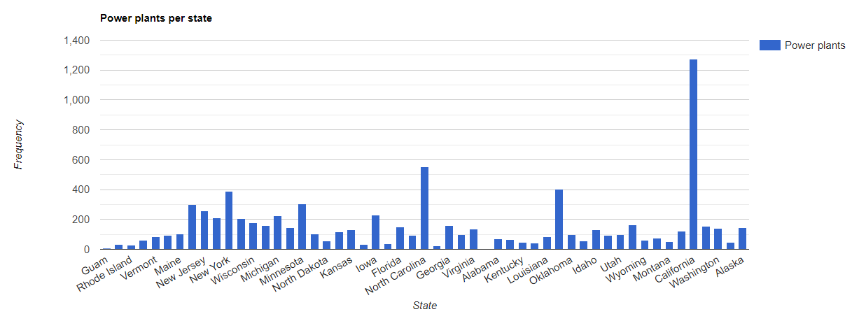
// Load the primary collection: US state boundaries.
var states = ee.FeatureCollection('TIGER/2018/States');

// Load the secondary collection: power plants.
var powerPlants = ee.FeatureCollection('WRI/GPPD/power_plants');

// Define a spatial filter as geometries that intersect.
var spatialFilter = ee.Filter.intersects({
  leftField: '.geo',
  rightField: '.geo',
  maxError: 10
});

// Define a save all join.
var saveAllJoin = ee.Join.saveAll({
  matchesKey: 'power_plants',
});

// Apply the join.
var intersectJoined = saveAllJoin.apply(states, powerPlants, spatialFilter);

// Add power plant count per state as a property.
intersectJoined = intersectJoined.map(function(state) {
  // Get "power_plant" intersection list, count how many intersected this state.
  var nPowerPlants = ee.List(state.get('power_plants')).size();
  // Return the state feature with a new property: power plant count.
  return state.set('n_power_plants', nPowerPlants);
});

// Make a bar chart for the number of power plants per state.
var chart = ui.Chart.feature.byFeature(intersectJoined, 'NAME', 'n_power_plants')
  .setChartType('ColumnChart')
  .setSeriesNames({n_power_plants: 'Power plants'})
  .setOptions({
    title: 'Power plants per state',
    hAxis: {title: 'State'},
    vAxis: {title: 'Frequency'}});

// Print the chart to the console.
print(chart);
W poprzednim przykładzie zwróć uwagę, że filtr intersects() nie przechowuje
odstępu, tak jak filtr withinDistance(). Dane wyjściowe powinny wyglądać mniej więcej tak jak na rysunku 1.