Anuncio: Todos los proyectos no comerciales registrados para usar Earth Engine antes del 15 de abril de 2025 deben verificar su elegibilidad no comercial para mantener el acceso a Earth Engine.
Organiza tus páginas con colecciones
Guarda y categoriza el contenido según tus preferencias.
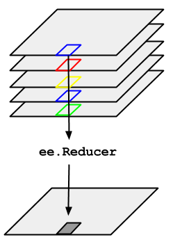
Considera el ejemplo de la necesidad de tomar la mediana de una serie temporal de imágenes representadas por un ImageCollection. Para reducir un ImageCollection, usa imageCollection.reduce(). Esto reduce la colección de imágenes a una imagen individual, como se ilustra en la Figura 1. Específicamente, el resultado se calcula por píxel, de modo que cada píxel del resultado se compone del valor medio de todas las imágenes de la colección en esa ubicación. Para obtener otras estadísticas, como la media, la suma, la variación, un percentil arbitrario, etc., se debe seleccionar y aplicar el reductor adecuado. (consulta la pestaña Docs en el editor de código para obtener una lista de todos los reductores disponibles actualmente). Para estadísticas básicas, como mínimo, máximo, promedio, etc.,
ImageCollection tiene métodos de acceso directo, como min(), max(), mean(), etc. Funcionan de la misma manera que llamar a reduce(), excepto que los nombres de banda resultantes no tendrán el nombre del reductor agregado.
Figura 1: Ilustración de un ee.Reducer aplicado a una ImageCollection.
Para ver un ejemplo de cómo reducir un ImageCollection, considera una colección de imágenes de Landsat 5, filtradas por ruta y fila. En el siguiente código, se usa reduce() para reducir la colección a un Image (aquí se usa un reductor de mediana solo a modo de ejemplo):
Esto muestra un Image de varias bandas, cada píxel del cual es la mediana de todos los píxeles sin enmascarar en el ImageCollection en esa ubicación de píxeles. Específicamente, el reductor se repitió para cada banda de las imágenes de entrada, lo que significa que la mediana se calcula de forma independiente en cada banda. Ten en cuenta que los nombres de las bandas tienen el nombre del
reductor agregado: 'B1_median', 'B2_median', etcétera.
El resultado debería verse como la Figura 2.
Para obtener más información sobre cómo reducir las colecciones de imágenes, consulta la sección de reducción de los documentos de ImageCollection. En particular, ten en cuenta que las imágenes producidas por reducir un ImageCollectionno tienen proyección. Esto significa que debes establecer explícitamente la escala en cualquier cálculo que involucre imágenes computadas que se generen con una reducción de ImageCollection.
Figura 2: Un compuesto de colores falsos de la mediana de las escenas de Landsat 5 en 2008.
[null,null,["Última actualización: 2025-07-25 (UTC)"],[[["\u003cp\u003eUse \u003ccode\u003eimageCollection.reduce()\u003c/code\u003e to reduce an \u003ccode\u003eImageCollection\u003c/code\u003e to a single image by applying a reducer function pixel-wise.\u003c/p\u003e\n"],["\u003cp\u003eEarth Engine provides built-in reducers for common statistics like median, mean, min, max, and more.\u003c/p\u003e\n"],["\u003cp\u003eThe output of \u003ccode\u003ereduce()\u003c/code\u003e is a multi-band image where each pixel represents the reduced value across the input images.\u003c/p\u003e\n"],["\u003cp\u003eBand names in the output image are appended with the reducer name (e.g., \u003ccode\u003eB1_median\u003c/code\u003e).\u003c/p\u003e\n"],["\u003cp\u003eReduced images have no projection, requiring explicit scale setting for further computations.\u003c/p\u003e\n"]]],[],null,["# ImageCollection Reductions\n\nConsider the example of needing to take the median over a time series of images\nrepresented by an `ImageCollection`. To reduce an `ImageCollection`,\nuse `imageCollection.reduce()`. This reduces the collection of images to an\nindividual image as illustrated in Figure 1. Specifically, the output is computed\npixel-wise, such that each pixel in the output is composed of the median value of all the\nimages in the collection at that location. To get other statistics, such as mean, sum,\nvariance, an arbitrary percentile, etc., the appropriate reducer should be selected and\napplied. (See the **Docs** tab in the\n[Code Editor](https://code.earthengine.google.com) for a list of all the reducers\ncurrently available). For basic statistics like min, max, mean, etc.,\n`ImageCollection` has shortcut methods like `min()`,\n`max()`, `mean()`, etc. They function in exactly the same way\nas calling `reduce()`, except the resultant band names will not have the\nname of the reducer appended.\nFigure 1. Illustration of an ee.Reducer applied to an ImageCollection.\n\nFor an example of reducing an `ImageCollection`, consider a collection of\nLandsat 5 images, filtered by path and row. The following code uses `reduce()`\nto reduce the collection to one `Image` (here a median reducer is used simply\nfor illustrative purposes):\n\n### Code Editor (JavaScript)\n\n```javascript\n// Load an image collection, filtered so it's not too much data.\nvar collection = ee.ImageCollection('LANDSAT/LT05/C02/T1')\n .filterDate('2008-01-01', '2008-12-31')\n .filter(ee.Filter.eq('WRS_PATH', 44))\n .filter(ee.Filter.eq('WRS_ROW', 34));\n\n// Compute the median in each band, each pixel.\n// Band names are B1_median, B2_median, etc.\nvar median = collection.reduce(ee.Reducer.median());\n\n// The output is an Image. Add it to the map.\nvar vis_param = {bands: ['B4_median', 'B3_median', 'B2_median'], gamma: 1.6};\nMap.setCenter(-122.3355, 37.7924, 9);\nMap.addLayer(median, vis_param);\n```\nPython setup\n\nSee the [Python Environment](/earth-engine/guides/python_install) page for information on the Python API and using\n`geemap` for interactive development. \n\n```python\nimport ee\nimport geemap.core as geemap\n```\n\n### Colab (Python)\n\n```python\n# Load an image collection, filtered so it's not too much data.\ncollection = (\n ee.ImageCollection('LANDSAT/LT05/C02/T1')\n .filterDate('2008-01-01', '2008-12-31')\n .filter(ee.Filter.eq('WRS_PATH', 44))\n .filter(ee.Filter.eq('WRS_ROW', 34))\n)\n\n# Compute the median in each band, each pixel.\n# Band names are B1_median, B2_median, etc.\nmedian = collection.reduce(ee.Reducer.median())\n\n# The output is an Image. Add it to the map.\nvis_param = {'bands': ['B4_median', 'B3_median', 'B2_median'], 'gamma': 1.6}\nm = geemap.Map()\nm.set_center(-122.3355, 37.7924, 9)\nm.add_layer(median, vis_param)\nm\n```\n\nThis returns a multi-band `Image`, each pixel of which is the median of all\nunmasked pixels in the `ImageCollection` at that pixel location. Specifically,\nthe reducer has been repeated for each band of the input imagery, meaning that the median\nis computed independently in each band. Note that the band names have the name of the\nreducer appended: `'B1_median'`, `'B2_median'`, etc.\nThe output should look something like Figure 2.\n\nFor more information about reducing image collections, see the\n[reducing section of the `ImageCollection` docs](/earth-engine/guides/ic_reducing). In\nparticular, note that images produced by reducing an `ImageCollection`\n[have no projection](/earth-engine/guides/ic_reducing#composites-have-no-projection). This means\nthat you should explicitly set the scale on any computations involving computed images\noutput by an `ImageCollection` reduction.\nFigure 2. A false color composite of the median of Landsat 5 scenes in 2008."]]