Pengumuman: Semua project nonkomersial yang terdaftar untuk menggunakan Earth Engine sebelum 15 April 2025 harus memverifikasi kelayakan nonkomersial untuk mempertahankan akses Earth Engine.
Tetap teratur dengan koleksi
Simpan dan kategorikan konten berdasarkan preferensi Anda.
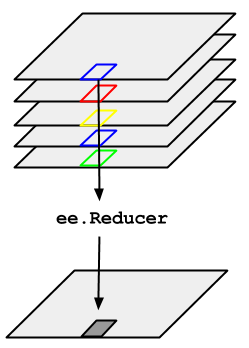
Pertimbangkan contoh perlunya mengambil median selama deret waktu gambar
yang direpresentasikan oleh ImageCollection. Untuk mengurangi ImageCollection,
gunakan imageCollection.reduce(). Hal ini akan mengurangi pengumpulan gambar menjadi
gambar individual seperti yang diilustrasikan dalam Gambar 1. Secara khusus, output dihitung
per piksel, sehingga setiap piksel dalam output terdiri dari nilai median dari semua
gambar dalam koleksi di lokasi tersebut. Untuk mendapatkan statistik lainnya, seperti rata-rata, jumlah, varians, persentil arbitrer, dsb., pengurangan yang sesuai harus dipilih dan diterapkan. (Lihat tab Dokumen di
Editor Kode untuk mengetahui daftar semua pengurangan
yang saat ini tersedia). Untuk statistik dasar seperti min, maks, mean, dll.,
ImageCollection memiliki metode pintasan seperti min(),
max(), mean(), dll. Metode ini berfungsi dengan cara yang sama
seperti memanggil reduce(), kecuali nama band yang dihasilkan tidak akan memiliki
nama pengurangan yang ditambahkan.
Gambar 1. Ilustrasi ee.Reducer yang diterapkan ke ImageCollection.
Untuk contoh pengurangan ImageCollection, pertimbangkan kumpulan gambar Landsat 5, yang difilter menurut jalur dan baris. Kode berikut menggunakan reduce()
untuk mengurangi koleksi menjadi satu Image (di sini pengurangan median digunakan hanya
untuk tujuan ilustrasi):
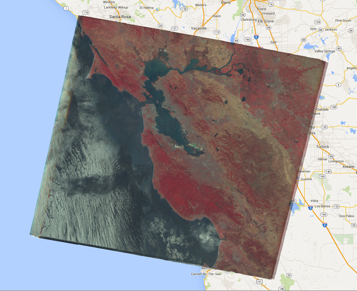
Tindakan ini akan menampilkan Image multi-band, yang setiap pikselnya adalah median dari semua
piksel yang tidak disamarkan dalam ImageCollection di lokasi piksel tersebut. Secara khusus, pengurangan telah diulang untuk setiap band gambar input, yang berarti median dihitung secara independen di setiap band. Perhatikan bahwa nama band memiliki nama pengurangan yang ditambahkan: 'B1_median', 'B2_median', dll. Output akan terlihat seperti Gambar 2.
Untuk informasi selengkapnya tentang cara mengurangi koleksi gambar, lihat
bagian pengurangan dalam dokumen ImageCollection. Secara
khusus, perhatikan bahwa gambar yang dihasilkan dengan mengurangi ImageCollectiontidak memiliki proyeksi. Artinya,
Anda harus menetapkan skala secara eksplisit pada komputasi apa pun yang melibatkan output gambar
yang dikomputasi dengan pengurangan ImageCollection.
Gambar 2. Komposisi warna palsu dari median scene Landsat 5 pada tahun 2008.
[null,null,["Terakhir diperbarui pada 2025-07-25 UTC."],[[["\u003cp\u003eUse \u003ccode\u003eimageCollection.reduce()\u003c/code\u003e to reduce an \u003ccode\u003eImageCollection\u003c/code\u003e to a single image by applying a reducer function pixel-wise.\u003c/p\u003e\n"],["\u003cp\u003eEarth Engine provides built-in reducers for common statistics like median, mean, min, max, and more.\u003c/p\u003e\n"],["\u003cp\u003eThe output of \u003ccode\u003ereduce()\u003c/code\u003e is a multi-band image where each pixel represents the reduced value across the input images.\u003c/p\u003e\n"],["\u003cp\u003eBand names in the output image are appended with the reducer name (e.g., \u003ccode\u003eB1_median\u003c/code\u003e).\u003c/p\u003e\n"],["\u003cp\u003eReduced images have no projection, requiring explicit scale setting for further computations.\u003c/p\u003e\n"]]],[],null,["# ImageCollection Reductions\n\nConsider the example of needing to take the median over a time series of images\nrepresented by an `ImageCollection`. To reduce an `ImageCollection`,\nuse `imageCollection.reduce()`. This reduces the collection of images to an\nindividual image as illustrated in Figure 1. Specifically, the output is computed\npixel-wise, such that each pixel in the output is composed of the median value of all the\nimages in the collection at that location. To get other statistics, such as mean, sum,\nvariance, an arbitrary percentile, etc., the appropriate reducer should be selected and\napplied. (See the **Docs** tab in the\n[Code Editor](https://code.earthengine.google.com) for a list of all the reducers\ncurrently available). For basic statistics like min, max, mean, etc.,\n`ImageCollection` has shortcut methods like `min()`,\n`max()`, `mean()`, etc. They function in exactly the same way\nas calling `reduce()`, except the resultant band names will not have the\nname of the reducer appended.\nFigure 1. Illustration of an ee.Reducer applied to an ImageCollection.\n\nFor an example of reducing an `ImageCollection`, consider a collection of\nLandsat 5 images, filtered by path and row. The following code uses `reduce()`\nto reduce the collection to one `Image` (here a median reducer is used simply\nfor illustrative purposes):\n\n### Code Editor (JavaScript)\n\n```javascript\n// Load an image collection, filtered so it's not too much data.\nvar collection = ee.ImageCollection('LANDSAT/LT05/C02/T1')\n .filterDate('2008-01-01', '2008-12-31')\n .filter(ee.Filter.eq('WRS_PATH', 44))\n .filter(ee.Filter.eq('WRS_ROW', 34));\n\n// Compute the median in each band, each pixel.\n// Band names are B1_median, B2_median, etc.\nvar median = collection.reduce(ee.Reducer.median());\n\n// The output is an Image. Add it to the map.\nvar vis_param = {bands: ['B4_median', 'B3_median', 'B2_median'], gamma: 1.6};\nMap.setCenter(-122.3355, 37.7924, 9);\nMap.addLayer(median, vis_param);\n```\nPython setup\n\nSee the [Python Environment](/earth-engine/guides/python_install) page for information on the Python API and using\n`geemap` for interactive development. \n\n```python\nimport ee\nimport geemap.core as geemap\n```\n\n### Colab (Python)\n\n```python\n# Load an image collection, filtered so it's not too much data.\ncollection = (\n ee.ImageCollection('LANDSAT/LT05/C02/T1')\n .filterDate('2008-01-01', '2008-12-31')\n .filter(ee.Filter.eq('WRS_PATH', 44))\n .filter(ee.Filter.eq('WRS_ROW', 34))\n)\n\n# Compute the median in each band, each pixel.\n# Band names are B1_median, B2_median, etc.\nmedian = collection.reduce(ee.Reducer.median())\n\n# The output is an Image. Add it to the map.\nvis_param = {'bands': ['B4_median', 'B3_median', 'B2_median'], 'gamma': 1.6}\nm = geemap.Map()\nm.set_center(-122.3355, 37.7924, 9)\nm.add_layer(median, vis_param)\nm\n```\n\nThis returns a multi-band `Image`, each pixel of which is the median of all\nunmasked pixels in the `ImageCollection` at that pixel location. Specifically,\nthe reducer has been repeated for each band of the input imagery, meaning that the median\nis computed independently in each band. Note that the band names have the name of the\nreducer appended: `'B1_median'`, `'B2_median'`, etc.\nThe output should look something like Figure 2.\n\nFor more information about reducing image collections, see the\n[reducing section of the `ImageCollection` docs](/earth-engine/guides/ic_reducing). In\nparticular, note that images produced by reducing an `ImageCollection`\n[have no projection](/earth-engine/guides/ic_reducing#composites-have-no-projection). This means\nthat you should explicitly set the scale on any computations involving computed images\noutput by an `ImageCollection` reduction.\nFigure 2. A false color composite of the median of Landsat 5 scenes in 2008."]]