تنظيم صفحاتك في مجموعات
يمكنك حفظ المحتوى وتصنيفه حسب إعداداتك المفضّلة.
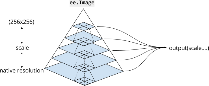
إنّ فهم كيفية تعامل Earth Engine مع النطاق أمر بالغ الأهمية لتفسير العلمي
النتائج التي يتم الحصول عليها من Earth Engine. ويشير مقياس الصورة هنا إلى درجة دقتها بوحدة البكسل. على عكس منصّات GIS ومعالجة الصور
الأخرى، يتم تحديد مقياس التحليل من خلال الإخراج،
وليس من خلال الإدخال. على وجه التحديد، عند طلب نتائج أو صورة لعرضها أو إحصاءات، على سبيل المثال، يمكنك تحديد المقياس الذي يتم إدخال البيانات فيه إلى التحليل. يوضّح الشكل 1 هذا المفهوم.
الشكل 1. تمثيل رسومي لمجموعة بيانات صور في Earth Engine
تمثّل الخطوط المنقطة سياسة التجميع في شكل هرم لتجميع الوحدات 2×2 من 4 بكسل. يستخدم محرّك
Earth مقياس الحجم المحدّد في الإخراج لتحديد المستوى المناسب من هرم
الصور لاستخدامه كإدخال.
أهرامات الصور
تتوفّر مواد عرض الصور في Earth Engine على مستويات متعدّدة، في
أهرامات الصور.
تحدّد سياسة التجميع (الممثّلة بالخطوط المنقطة في الشكل 1) كيفية احتساب كل بكسل
في مستوى معيّن من الهرم من خلال تجميع مجموعة من 2×2 بكسل
في المستوى الأدنى التالي. بالنسبة إلى الصور ذات القيم المستمرة، تكون قيم وحدات البكسل للمستويات العليا من الهرم هي متوسط وحدات البكسل في المستوى الأدنى التالي. بالنسبة إلى الصور ذات القيم المنفصلة،
تكون قيم وحدات البكسل في المستويات العليا من الهرم عيّنة (عادةً وحدات البكسل في أعلى يمين الصورة) من
وحدات البكسل في المستوى الأدنى التالي.
يمثّل أدنى مستوى من هرم الصور بيانات الصورة بدقة أصلية، عند نقلها
إلى Earth Engine. أثناء نقل البيانات، يتم تجميعها (وفقًا لسياسة
التجميع) لإنشاء مستويات أعلى من الهرم. يتم تجميع البيانات إلى أن تلائم
الصورة بأكملها مربّعًا بحجم 256 x 256 بكسل. عند استخدام صورة في الرمز البرمجي،
يختار Earth Engine مستوى من الهرم باستخدام أقرب مقياس أقل من أو يساوي
المقياس المحدّد من خلال التحليل، ويعيد تحليل العينة (باستخدام أقرب جار تلقائيًا)
حسب الحاجة.
نطاق التحليل
يتم تحديد نطاق التحليل في Earth Engine استنادًا إلى "السحب". يتم تحديد المقياس الذي يتم عنده
طلب مدخلات لإجراء عملية حسابية من خلال الإخراج. على سبيل المثال، إذا
أضفت صورة إلى "محرر الرموز" أو عنصر خريطة geemap، يحدّد مستوى تكبير الخريطة
المقياس الذي يتمّ طلب الإدخالات من هرم الصور وفقًا له. بالنسبة إلى العمليات الحسابية الأخرى، يمكنك
تحديد scale كوسيطة. على سبيل المثال، باستخدام نطاق الأشعة تحت الحمراء القريبة من صورة Landsat
التي تبلغ دقتها الأصلية 30 مترًا:
في هذا المثال، يُرجى العِلم أنّ قيمة البكسل في موقع ثابت (مركز الصورة)
تختلف حسب المقياس. ويرجع ذلك إلى أنّه يتم اختيار مستويات مختلفة من الهرم
لقياسات مختلفة. بالنسبة إلى المقاييس المتشابهة، تؤدي إعادة أخذ عيّنات أقرب العناصر إلى عرض قيمة بكسل مماثلة. النقطة المهمة هي أنّه من خلال تغيير المقياس، يتم طلب إدخالات
صور مختلفة.
عند عرض صورة من خلال إضافتها إلى الخريطة، تحدِّد Earth Engine المقياس من
مستوى التكبير/التصغير. راجِع المثال البسيط التالي الذي يعرض صورة Landsat:
تبدأ الخريطة مكبَّرة إلى أقصى حدّ، بحيث تظهر وحدات البكسل ذات الدقة الأصلية بوضوح. لن يؤدي التصغير إلى مسافة كافية إلى عرض وحدات البكسل نفسها، بل سيؤدي بدلاً من ذلك
إلى عرض مستويات أعلى من هرم الصورة. تجدر الإشارة أيضًا إلى أنّ "محرر الرموز"
وخرائط geemap يستخدمان إسقاط maps mercator (EPSG:3857)
، لذا يجب أيضًا إعادة إسقاط المستوى المناسب من هرم الصور
قبل عرضه. اطّلِع على مزيد من المعلومات حول كيفية تعامل Earth Engine مع التوقّعات من
مستند التوقّعات.
تاريخ التعديل الأخير: 2025-07-25 (حسب التوقيت العالمي المتفَّق عليه)
[null,null,["تاريخ التعديل الأخير: 2025-07-25 (حسب التوقيت العالمي المتفَّق عليه)"],[[["\u003cp\u003eIn Earth Engine, the scale of analysis, referring to pixel resolution, is determined by the output rather than the input, unlike other GIS platforms.\u003c/p\u003e\n"],["\u003cp\u003eEarth Engine utilizes image pyramids, where each level represents the image at a different scale, with pixel values aggregated from lower levels.\u003c/p\u003e\n"],["\u003cp\u003eThe scale you specify in your analysis dictates which level of the image pyramid Earth Engine uses as input, influencing the results you obtain.\u003c/p\u003e\n"],["\u003cp\u003eWhen visualizing images on the map, the zoom level determines the scale, and Earth Engine automatically selects the appropriate pyramid level for display.\u003c/p\u003e\n"],["\u003cp\u003eTo ensure consistent and accurate results, it's crucial to explicitly specify the desired scale when using functions with a scale parameter in Earth Engine.\u003c/p\u003e\n"]]],[],null,["# Scale\n\nUnderstanding how Earth Engine handles scale is crucial to interpreting scientific\nresults obtained from Earth Engine. Here, scale means pixel resolution. Unlike other\nGIS and image processing platforms, the scale of analysis is determined from the output,\nrather than the input. Specifically, when you make a request for results, an image to\ndisplay or a statistic, for example, you specify the scale at which data is input to the\nanalysis. This concept is illustrated in Figure 1.\nFigure 1. A graphic representation of an image dataset in Earth Engine. Dashed lines represent the pyramiding policy for aggregating 2x2 blocks of 4 pixels. Earth Engine uses the scale specified by the output to determine the appropriate level of the image pyramid to use as input.\n\nImage Pyramids\n--------------\n\nImage assets in Earth Engine exist at multiple scales, in\n[image pyramids](https://en.wikipedia.org/wiki/Pyramid_(image_processing)).\nThe pyramiding policy (represented by dashed lines in Figure 1) determines how each pixel\nat a given level of the pyramid is computed from the aggregation of a 2x2 block of pixels\nat the next lower level. For continuous valued images, the pixel values of upper levels of\nthe pyramid are the mean of pixels at the next lower level. For discrete valued images,\npixel values of upper levels of the pyramid are a sample (usually the top left pixel) of\npixels at the next lower level.\n\nThe lowest level of the image pyramid represents image data at native resolution, when it is\ningested into Earth Engine. During ingestion, the data are aggregated (according to the\npyramiding policy) to create higher pyramid levels. The data are aggregated until the\nentire image fits within a 256x256 pixel tile. When you use an image in your code,\nEarth Engine chooses a level of the pyramid with the closest scale less than or equal to\nthe scale specified by your analysis and resamples (using nearest neighbor by default)\nas necessary.\n\nScale of analysis\n-----------------\n\nScale of analysis in Earth Engine is determined on a \"pull\" basis. The scale at which\nto request inputs to a computation is determined from the output. For example, if you\nadd an image to the Code Editor or geemap map element, the zoom level of the map determines\nthe scale at which inputs are requested from the image pyramid. For other computations, you\nspecify `scale` as an argument. For example, using the NIR band of a Landsat\nimage, which has 30 meters native resolution:\n\n### Code Editor (JavaScript)\n\n```javascript\nvar image = ee.Image('LANDSAT/LC08/C02/T1_TOA/LC08_044034_20140318').select('B4');\n\nvar printAtScale = function(scale) {\n print('Pixel value at '+scale+' meters scale',\n image.reduceRegion({\n reducer: ee.Reducer.first(),\n geometry: image.geometry().centroid(),\n // The scale determines the pyramid level from which to pull the input\n scale: scale\n }).get('B4'));\n};\n\nprintAtScale(10); // 0.10394100844860077\nprintAtScale(30); // 0.10394100844860077\nprintAtScale(50); // 0.09130698442459106\nprintAtScale(70); // 0.1150854229927063\nprintAtScale(200); // 0.102478988468647\nprintAtScale(500); // 0.09072770178318024\n```\nPython setup\n\nSee the [Python Environment](/earth-engine/guides/python_install) page for information on the Python API and using\n`geemap` for interactive development. \n\n```python\nimport ee\nimport geemap.core as geemap\n```\n\n### Colab (Python)\n\n```python\nimage = ee.Image('LANDSAT/LC08/C02/T1_TOA/LC08_044034_20140318').select('B4')\n\n\ndef print_at_scale(scale):\n display(\n f'Pixel value at {scale} meters scale',\n image.reduceRegion(\n reducer=ee.Reducer.first(),\n geometry=image.geometry().centroid(),\n # The scale determines the pyramid level from which to pull the input\n scale=scale,\n ).get('B4'),\n )\n\n\nprint_at_scale(10) # 0.10394100844860077\nprint_at_scale(30) # 0.10394100844860077\nprint_at_scale(50) # 0.09130698442459106\nprint_at_scale(70) # 0.1150854229927063\nprint_at_scale(200) # 0.102478988468647\nprint_at_scale(500) # 0.09072770178318024\n```\n\nIn this example, note that the pixel value at a constant location (the image centroid)\nvaries based on scale. This is due to the fact that different pyramid levels are selected\nfor different scales. For similar scales, nearest neighbor resampling results in the same\npixel value being returned. The important point is that by varying the scale, different\nimage inputs are requested.\n| **Note:** To avoid ambiguity, always specify scale when you use a function which has a scale parameter.\n\nWhen you visualize an image by adding it to the map, Earth Engine determines scale from\nthe zoom level. Consider the following simple example, which simply displays a Landsat\nimage:\n\n### Code Editor (JavaScript)\n\n```javascript\nvar image = ee.Image('LANDSAT/LC08/C02/T1_TOA/LC08_044034_20140318');\nMap.centerObject(image, 17);\nMap.addLayer(image, {bands: ['B4', 'B3', 'B2'], max: 0.35}, 'image');\n```\nPython setup\n\nSee the [Python Environment](/earth-engine/guides/python_install) page for information on the Python API and using\n`geemap` for interactive development. \n\n```python\nimport ee\nimport geemap.core as geemap\n```\n\n### Colab (Python)\n\n```python\nimage = ee.Image('LANDSAT/LC08/C02/T1_TOA/LC08_044034_20140318')\nm = geemap.Map()\nm.center_object(image, 17)\nm.add_layer(image, {'bands': ['B4', 'B3', 'B2'], 'max': 0.35}, 'image')\nm\n```\n\nThe map starts zoomed all the way in, such that the native resolution pixels are clearly\nvisible. Zooming out far enough will not display the same pixels, but will instead\ndisplay higher levels of the image pyramid. It is also worth noting that the Code Editor\nand geemap maps use the [maps mercator (EPSG:3857)](http://epsg.io/3857)\nprojection, so the appropriate level of the image pyramid also needs to be reprojected prior\nto display. Learn more about how Earth Engine handles projections from the\n[projections doc](/earth-engine/guides/projections)."]]