إشعار: يجب
إثبات أهلية جميع المشاريع غير التجارية المسجّلة لاستخدام Earth Engine قبل
15 أبريل 2025 من أجل الحفاظ على إمكانية الوصول إلى Earth Engine.
التحقّق من الصور غير المتوفّرة في "كتالوج البيانات"
تنظيم صفحاتك في مجموعات
يمكنك حفظ المحتوى وتصنيفه حسب إعداداتك المفضّلة.
الغرض من هذا المستند هو مساعدتك في تحديد ما إذا كانت مادة العرض مفقودة
في كتالوج بيانات Earth Engine (المعروف حاليًا باسم Landsat وSentinel وMODIS).
توضّح الخطوات الموضّحة كيفية تنفيذ ما يلي:
النقاط الشائعة التي يجب أخذها في الاعتبار
مستوى المعالجة: قد لا تكون بعض الصور متاحة لمستوى معالجة أو منتج معيّن. على سبيل المثال، قد لا تتم معالجة الصور المنخفضة الجودة
بالمستوى الأعلى.
التغطية المكانية والزمانية: لا يمكن ضمان اتّباع وتيرة منتظمة لكل مجموعة بيانات. يمكن أن يؤثّر الاختلاف في مهام أداة الاستشعار وجودة الصورة
وإدارة الأرشيف في مدى توفّر بيانات مقدّم الخدمة.
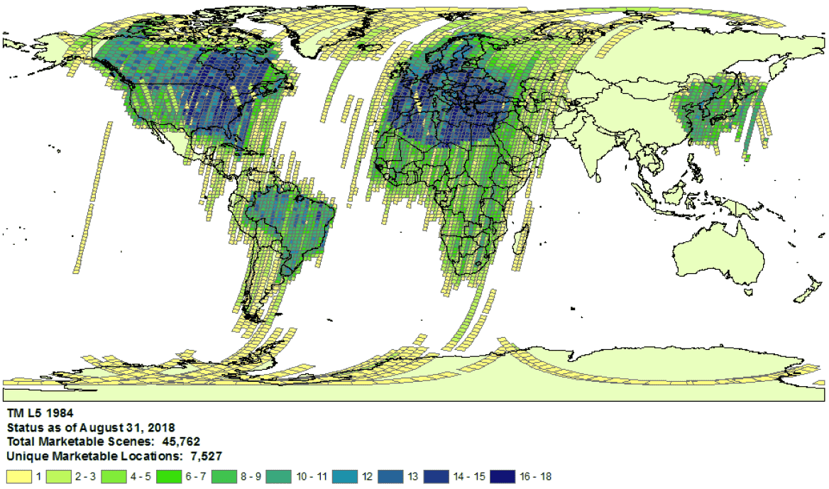
مثال على تغطية جمع قياسات Landsat 5 للعام
1984
- اختيار مقدّم الخدمة: يتم نقل البيانات إلى "قائمة بيانات Earth Engine"
من مقدّم خدمة محدّد لكل مجموعة بيانات. من المحتمَل أنّ مقدّم الخدمة
لا يقدّم أرشيفًا كاملاً للمهام. على سبيل المثال، يتم نقل حِزم بيانات Landsat
من أرشيف USGS، والذي يُعرف أنّه لا يتضمّن صورًا من
محطات استقبال معيّنة لفترات زمنية معيّنة (اطّلِع على
جهود LGAC
لمزيد من المعلومات).
Landsat
يتم نقل بيانات Landsat من
مسح المساحة الجيولوجية في الولايات المتحدة
(USGS).
تأكَّد من
توفّر تغطية Landsat
للوقت والمنطقة المعنيّة.
أجرِ عملية بحث في Earth Engine للحصول على قائمة بجميع مواد العرض للوقت
والمنطقة التي تهمّك. احرص على التأكّد من عدم ترشيح أي مواد عرض
عن طريق الخطأ في الرمز البرمجي.
في ما يلي مثال على نص برمجي.
احرص على استيراد المجموعة باستخدام المستوى المناسب من الفئة ومعالجة
البيانات (اطّلِع على مزيد من المعلومات
حول بنية مجموعة Landsat).
ابحث عن مواد العرض التي يُحتمل أن تكون غير متوفّرة في كتالوج
USGS Earth Explorer (اطّلِع على دليل المساعدة
للحصول على خطوات تفصيلية حول
إجراء عملية بحث
واختيار مجموعات البيانات).
تأكَّد من مقارنة المنتجات ومستويات المعالجة المناسبة
(اطّلِع على بنية مجموعة Landsat).
يُرجى العِلم أنّه لا يتم إنشاء منتجات انعكاس سطح الأرض إلا لصور Landsat التي تتضمن
مستوى المعالجة
L1TP.
شارِك دليلاً مفصّلاً على عدم توفّر مواد العرض من خلال إرسال طلب يتضمن معرّف منتج الموفّر ورابط يؤدي إلى نص برمجي في "محرر الرموز البرمجية في Earth Engine" يؤكّد عدم توفّر مواد العرض.
Sentinel
يتم نقل بيانات Sentinel من
موقع Copernicus Dataspace الإلكتروني.
تأكَّد من
توفّر تغطية Sentinel للوقت والمنطقة المعنيّة (راجِع
تفاصيل المهمة).
ملاحظة: يتم إنشاء منتجات Sentinel-2 Level-2A بشكل منهجي في
الجزء الأرضي فوق أوروبا فقط منذ آذار (مارس) 2018، وتم توسيع نطاق الإنتاج
ليشمل العالم في كانون الأول (ديسمبر) 2018 (اطّلِع على
دليل مستخدم وكالة الفضاء الأوروبية
للاطّلاع على مزيد من التفاصيل).
وسيتمّ إنشاؤها مجددًا في نهاية المطاف كجزء من المجموعة 1.
أجرِ عملية بحث في Earth Engine للحصول على قائمة بجميع مواد العرض للوقت
والمنطقة التي تهمّك. احرص على التأكّد من عدم ترشيح أي مواد عرض
عن طريق الخطأ في الرمز البرمجي. في ما يلي مثال على نص برمجي.
احرص على استيراد المجموعة بالمستوى الصحيح لمعالجة
البيانات.
ابحث عن مواد العرض التي يُحتمل أن تكون غير متوفّرة في
كتالوج Copernicus.
شارِك دليلاً مفصّلاً على عدم توفّر مواد العرض من خلال إرسال طلب يتضمن معرّف منتج الموفّر ورابط يؤدي إلى نص برمجي في "محرر الرموز البرمجية في Earth Engine" يؤكّد عدم توفّر مواد العرض.
MODIS
يتم نقل بيانات MODIS من
مركز الأرشيف النشط الموزّع لعمليات سطح الأرض
(LP DAAC).
أجرِ عملية بحث في Earth Engine للحصول على قائمة بجميع مواد العرض للوقت
والمنطقة التي تهمّك. احرص على التأكّد من عدم ترشيح أي مواد عرض
عن طريق الخطأ في الرمز البرمجي. في ما يلي مثال على نص برمجي.
تأكَّد من استيراد المنتج المقصود.
ابحث عن مواد العرض التي يُحتمل أن تكون غير متوفّرة في
مجموعة بيانات USGS والتي لم تتم
إضافتها إلى Earth Engine. انتقِل إلى المجلد المناسب وحدِّد
أحدث الأدلة المتاحة.
شارِك دليلاً مفصّلاً على عدم توفّر مواد العرض من خلال إرسال طلب يتضمن معرّف منتج الموفّر ورابط يؤدي إلى نص برمجي في "محرر الرموز البرمجية في Earth Engine" يؤكّد عدم توفّر مواد العرض.
إنّ محتوى هذه الصفحة مرخّص بموجب ترخيص Creative Commons Attribution 4.0 ما لم يُنصّ على خلاف ذلك، ونماذج الرموز مرخّصة بموجب ترخيص Apache 2.0. للاطّلاع على التفاصيل، يُرجى مراجعة سياسات موقع Google Developers. إنّ Java هي علامة تجارية مسجَّلة لشركة Oracle و/أو شركائها التابعين.
تاريخ التعديل الأخير: 2025-07-25 (حسب التوقيت العالمي المتفَّق عليه)
[null,null,["تاريخ التعديل الأخير: 2025-07-25 (حسب التوقيت العالمي المتفَّق عليه)"],[[["\u003cp\u003eThis document provides guidance to determine if a Landsat, Sentinel, or MODIS asset is missing from the Earth Engine Data Catalog.\u003c/p\u003e\n"],["\u003cp\u003eUsers can verify potential missing assets by checking the provider's catalog and comparing it against the Earth Engine catalog.\u003c/p\u003e\n"],["\u003cp\u003eDetailed information, including the provider's product ID and an Earth Engine script, must be submitted when reporting missing assets.\u003c/p\u003e\n"],["\u003cp\u003eVariances in data availability may occur due to factors like processing levels, spatiotemporal coverage, and provider data archives.\u003c/p\u003e\n"]]],["To find missing assets in the Earth Engine Data Catalog, first, check provider catalogs (USGS, Copernicus, or LP DAAC) for coverage availability. Next, search Earth Engine, ensuring no filters exclude assets. Compare results to the provider's catalog. For Landsat, use USGS Earth Explorer; for Sentinel, use the Copernicus catalog; and for MODIS, use the USGS Data Pool. Finally, report any discrepancies to the Earth Engine team via a ticket, including the provider's product ID and an Earth Engine script link.\n"],null,["# Verify Missing Images in the Data Catalog\n\nThe purpose of this document is to help you determine if an asset is missing\nin the Earth Engine Data Catalog (currently Landsat, Sentinel, and MODIS).\n\nThe steps outlined describe how to:\n\n- Check for available assets in Earth Engine's and providers' catalogs.\n\n- Collect information needed to submit confirmation of a missing\n asset to the Earth Engine data team.\n\nCommon things to consider\n-------------------------\n\n- **Processing level**: not all images may be available for a given processing\n level or product. For instance, low-quality images may not be processed\n to the highest level.\n\n- **Spatiotemporal coverage**: a regular cadence is not\n guaranteed for each dataset. Variation in sensor tasking, image quality,\n and archive management can affect provider data availability.\n\n\nExample of Landsat 5\n[collection coverage](https://landsat.usgs.gov/usgs-landsat-global-archive) for\n1984.\n\n- **Provider choice** : data are ingested into the Earth Engine Data Catalog from a selected provider per dataset. It is possible that the provider does not offer a complete mission archive. For example, Landsat datasets are ingested from the USGS archive, which is known to be missing imagery from certain receiving stations for certain periods of time (see the [LGAC effort](https://www.usgs.gov/land-resources/nli/landsat/landsat-global-archive-consolidation?qt-science_support_page_related_con=3#qt-science_support_page_related_con) for more information).\n\nLandsat\n-------\n\nLandsat data are ingested from the\n[U.S. Geological Survey](https://www.usgs.gov/land-resources/nli/landsat)\n(USGS).\n\n1. Confirm\n [Landsat coverage availability](https://landsat.usgs.gov/usgs-landsat-global-archive)\n for the time and area of interest.\n\n2. Perform a search in Earth Engine to get a list of all assets for the time and\n area of interest. Take care to ensure no assets have been accidentally\n filtered out within your code.\n Here is an [example script](https://code.earthengine.google.com/975bff3a2ff955e5f884005b5dd2bafb);\n be sure you are importing the collection with the right tier and processing\n level (learn more\n [about the Landsat collection structure](https://developers.google.com/earth-engine/landsat#landsat-collection-structure)).\n\n3. Look for potentially missing assets in the\n [USGS Earth Explorer](https://earthexplorer.usgs.gov/) catalog (see the help\n guide for detailed steps on\n [performing a search](https://lta.cr.usgs.gov/EEHelp/ee_tutorial_search_criteria)\n and [selecting datasets](https://lta.cr.usgs.gov/EEHelp/ee_tutorial_search_datasets)).\n Make sure you are comparing the right products and processing levels\n ([see Landsat collection structure](https://developers.google.com/earth-engine/landsat#landsat-collection-structure)).\n Note that surface reflectance products are only generated for Landsat images with\n processing level\n [L1TP](https://www.usgs.gov/land-resources/nli/landsat/landsat-levels-processing).\n\n4. Share detailed evidence of missing assets by submitting a\n [ticket](https://issuetracker.google.com/issues/new?component=184406&template=1254745)\n with the provider's product ID and a\n [link](https://developers.google.com/earth-engine/playground#get-link)\n to an Earth Engine Code Editor script confirming the absence of the assets.\n\nSentinel\n--------\n\nSentinel data are ingested from the\n[Copernicus Dataspace site](https://dataspace.copernicus.eu/).\n\n1. Confirm\n Sentinel coverage availability for the time and area of interest (see\n [mission details](https://sentinel.esa.int/web/sentinel/missions)).\n\n *Note* : Sentinel-2 Level-2A products are systematically generated at the\n ground segment over Europe only since March 2018, and the production\n was extended to global in December 2018 (see\n [ESA User Guide](https://sentinel.esa.int/web/sentinel/user-guides/sentinel-2-msi)\n for more details).\n They will eventually be regenerated as a part of Collection 1.\n2. Perform a search in Earth Engine to get a list of all assets for the time and\n area of interest. Take care to ensure no assets have been accidentally\n filtered out within your code. Here is an\n [example script](https://code.earthengine.google.com/4bebc6b8b44807a2001bc34d49fc25eb);\n be sure you are importing the collection with the right processing\n level.\n\n3. Look for potentially missing assets in the\n [Copernicus catalog](https://dataspace.copernicus.eu/browser/).\n\n4. Share detailed evidence of missing assets by submitting a\n [ticket](https://issuetracker.google.com/issues/new?component=184406&template=1254745)\n with the provider's product ID and a\n [link](https://developers.google.com/earth-engine/playground#get-link)\n to an Earth Engine Code Editor script confirming the absence of the assets.\n\nMODIS\n-----\n\nMODIS data are ingested from the\n[Land Processes Distributed Active Archive Center](https://lpdaac.usgs.gov/)\n(LP DAAC).\n\n1. Perform a search in Earth Engine to get a list of all assets for the time and\n area of interest. Take care to ensure no assets have been accidentally\n filtered out within your code. Here is an\n [example script](https://code.earthengine.google.com/848200c362694900b6027b30b0e99677);\n be sure you are importing the intended product.\n\n2. Look for potentially missing assets in the\n [USGS Data Pool](https://lpdaac.usgs.gov/tools/data-pool/) that have not been\n added to Earth Engine. Navigate to the appropriate folder and identify the\n latest directories available.\n\n - Datasets starting with \"MOD\" are in\n \"[Terra MODIS](https://e4ftl01.cr.usgs.gov/MOLT/)\"\n\n - Datasets starting with \"MYD\" are in\n \"[Aqua MODIS](https://e4ftl01.cr.usgs.gov/MOLA/)\"\n\n - Datasets starting with \"MCD\" are in\n \"[Combined MODIS](https://e4ftl01.cr.usgs.gov/MOTA/)\"\n\n - Datasets starting with \"VNP\" are in\n \"[S-NPP VIIRS](https://e4ftl01.cr.usgs.gov/VIIRS/)\"\n\n3. Share detailed evidence of missing assets by submitting a\n [ticket](https://issuetracker.google.com/issues/new?component=184406&template=1254745)\n with the provider's product ID and a\n [link](https://developers.google.com/earth-engine/playground#get-link)\n to an Earth Engine Code Editor script confirming the absence of the assets."]]