تصاویر گم شده را در کاتالوگ داده تأیید کنید
با مجموعهها، منظم بمانید
ذخیره و طبقهبندی محتوا براساس اولویتهای شما.
هدف این سند این است که به شما کمک کند تعیین کنید آیا یک دارایی در کاتالوگ داده موتور زمین (در حال حاضر Landsat، Sentinel و MODIS) وجود ندارد یا خیر.
مراحل ذکر شده شرح می دهد که چگونه:
موارد رایجی که باید در نظر بگیرید
سطح پردازش : ممکن است همه تصاویر برای یک سطح پردازش یا محصول معین در دسترس نباشند. به عنوان مثال، تصاویر با کیفیت پایین ممکن است به بالاترین سطح پردازش نشوند.
پوشش مکانی - زمانی : یک آهنگ منظم برای هر مجموعه داده تضمین نشده است. تغییر در وظایف حسگر، کیفیت تصویر و مدیریت بایگانی میتواند بر در دسترس بودن دادههای ارائهدهنده تأثیر بگذارد.
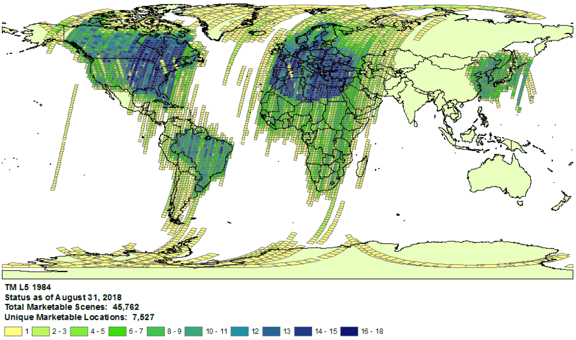
نمونه ای از پوشش مجموعه لندست 5 برای سال 1984.
- انتخاب ارائهدهنده : دادهها در کاتالوگ داده موتور زمین از یک ارائهدهنده انتخابشده در هر مجموعه داده وارد میشوند. این امکان وجود دارد که ارائه دهنده یک آرشیو کامل ماموریت را ارائه ندهد. به عنوان مثال، مجموعه دادههای Landsat از بایگانی USGS دریافت میشوند، که مشخص است تصاویری از ایستگاههای دریافت خاص برای دورههای زمانی معینی از دست داده است (برای اطلاعات بیشتر به تلاش LGAC مراجعه کنید).
لندست
داده های Landsat از سازمان زمین شناسی ایالات متحده (USGS) دریافت شده است.
در دسترس بودن پوشش Landsat را برای زمان و منطقه مورد علاقه تأیید کنید.
جستجویی را در Earth Engine انجام دهید تا لیستی از همه دارایی ها را برای زمان و منطقه مورد علاقه دریافت کنید. مراقب باشید که هیچ دارایی به طور تصادفی در کد شما فیلتر نشده باشد. در اینجا یک نمونه اسکریپت آمده است. مطمئن شوید که مجموعه را با سطح و سطح پردازش مناسب وارد می کنید ( در مورد ساختار مجموعه لندست بیشتر بیاموزید).
به دنبال داراییهای گمشده بالقوه در کاتالوگ USGS Earth Explorer بگردید (راهنمای راهنما برای مراحل دقیق انجام جستجو و انتخاب مجموعههای داده را ببینید). مطمئن شوید که محصولات و سطوح پردازش مناسب را با هم مقایسه می کنید ( به ساختار مجموعه Landsat مراجعه کنید ). توجه داشته باشید که محصولات بازتاب سطحی فقط برای تصاویر Landsat با سطح پردازش L1TP تولید می شوند.
با ارسال یک بلیت با شناسه محصول ارائهدهنده و پیوندی به اسکریپت ویرایشگر کد موتور Earth که عدم وجود داراییها را تأیید میکند، شواهد دقیقی درباره داراییهای گمشده به اشتراک بگذارید.
نگهبان
دادههای Sentinel از سایت Copernicus Dataspace دریافت میشوند.
در دسترس بودن پوشش Sentinel را برای زمان و منطقه مورد علاقه تأیید کنید (به جزئیات ماموریت مراجعه کنید).
توجه : محصولات Sentinel-2 Level-2A فقط از مارس 2018 به طور سیستماتیک در بخش زمینی در اروپا تولید می شوند و تولید در دسامبر 2018 به سطح جهانی گسترش یافت (برای جزئیات بیشتر به راهنمای کاربر ESA مراجعه کنید). آنها در نهایت به عنوان بخشی از مجموعه 1 بازسازی خواهند شد.
جستجویی را در Earth Engine انجام دهید تا لیستی از همه دارایی ها را برای زمان و منطقه مورد علاقه دریافت کنید. مراقب باشید که هیچ دارایی به طور تصادفی در کد شما فیلتر نشده باشد. در اینجا یک نمونه اسکریپت آمده است. مطمئن شوید که مجموعه را با سطح پردازش مناسب وارد می کنید.
به دنبال دارایی های گمشده بالقوه در کاتالوگ کوپرنیک باشید.
با ارسال یک بلیت با شناسه محصول ارائهدهنده و پیوندی به اسکریپت ویرایشگر کد موتور Earth که عدم وجود داراییها را تأیید میکند، شواهد دقیقی درباره داراییهای گمشده به اشتراک بگذارید.
MODIS
دادههای MODIS از مرکز بایگانی فعال توزیعشده فرآیندهای زمین (LP DAAC) دریافت میشود.
جستجویی را در Earth Engine انجام دهید تا لیستی از همه دارایی ها را برای زمان و منطقه مورد علاقه دریافت کنید. مراقب باشید که هیچ دارایی به طور تصادفی در کد شما فیلتر نشده باشد. در اینجا یک نمونه اسکریپت آمده است. مطمئن شوید که محصول مورد نظر را وارد می کنید.
به دنبال داراییهای گمشده بالقوه در USGS Data Pool باشید که به Earth Engine اضافه نشدهاند. به پوشه مناسب بروید و آخرین دایرکتوری های موجود را شناسایی کنید.
مجموعه داده هایی که با "MOD" شروع می شوند در " Terra MODIS " هستند
مجموعه داده هایی که با "MYD" شروع می شوند در " Aqua MODIS " هستند
مجموعه داده هایی که با "MCD" شروع می شوند در " MODIS ترکیبی " هستند
مجموعه داده هایی که با "VNP" شروع می شوند در " S-NPP VIIRS " هستند
با ارسال یک بلیت با شناسه محصول ارائهدهنده و پیوندی به اسکریپت ویرایشگر کد موتور Earth که عدم وجود داراییها را تأیید میکند، شواهد دقیقی درباره داراییهای گمشده به اشتراک بگذارید.
جز در مواردی که غیر از این ذکر شده باشد،محتوای این صفحه تحت مجوز Creative Commons Attribution 4.0 License است. نمونه کدها نیز دارای مجوز Apache 2.0 License است. برای اطلاع از جزئیات، به خطمشیهای سایت Google Developers مراجعه کنید. جاوا علامت تجاری ثبتشده Oracle و/یا شرکتهای وابسته به آن است.
تاریخ آخرین بهروزرسانی 2025-07-24 بهوقت ساعت هماهنگ جهانی.
[null,null,["تاریخ آخرین بهروزرسانی 2025-07-24 بهوقت ساعت هماهنگ جهانی."],[[["\u003cp\u003eThis document provides guidance to determine if a Landsat, Sentinel, or MODIS asset is missing from the Earth Engine Data Catalog.\u003c/p\u003e\n"],["\u003cp\u003eUsers can verify potential missing assets by checking the provider's catalog and comparing it against the Earth Engine catalog.\u003c/p\u003e\n"],["\u003cp\u003eDetailed information, including the provider's product ID and an Earth Engine script, must be submitted when reporting missing assets.\u003c/p\u003e\n"],["\u003cp\u003eVariances in data availability may occur due to factors like processing levels, spatiotemporal coverage, and provider data archives.\u003c/p\u003e\n"]]],["To find missing assets in the Earth Engine Data Catalog, first, check provider catalogs (USGS, Copernicus, or LP DAAC) for coverage availability. Next, search Earth Engine, ensuring no filters exclude assets. Compare results to the provider's catalog. For Landsat, use USGS Earth Explorer; for Sentinel, use the Copernicus catalog; and for MODIS, use the USGS Data Pool. Finally, report any discrepancies to the Earth Engine team via a ticket, including the provider's product ID and an Earth Engine script link.\n"],null,["# Verify Missing Images in the Data Catalog\n\nThe purpose of this document is to help you determine if an asset is missing\nin the Earth Engine Data Catalog (currently Landsat, Sentinel, and MODIS).\n\nThe steps outlined describe how to:\n\n- Check for available assets in Earth Engine's and providers' catalogs.\n\n- Collect information needed to submit confirmation of a missing\n asset to the Earth Engine data team.\n\nCommon things to consider\n-------------------------\n\n- **Processing level**: not all images may be available for a given processing\n level or product. For instance, low-quality images may not be processed\n to the highest level.\n\n- **Spatiotemporal coverage**: a regular cadence is not\n guaranteed for each dataset. Variation in sensor tasking, image quality,\n and archive management can affect provider data availability.\n\n\nExample of Landsat 5\n[collection coverage](https://landsat.usgs.gov/usgs-landsat-global-archive) for\n1984.\n\n- **Provider choice** : data are ingested into the Earth Engine Data Catalog from a selected provider per dataset. It is possible that the provider does not offer a complete mission archive. For example, Landsat datasets are ingested from the USGS archive, which is known to be missing imagery from certain receiving stations for certain periods of time (see the [LGAC effort](https://www.usgs.gov/land-resources/nli/landsat/landsat-global-archive-consolidation?qt-science_support_page_related_con=3#qt-science_support_page_related_con) for more information).\n\nLandsat\n-------\n\nLandsat data are ingested from the\n[U.S. Geological Survey](https://www.usgs.gov/land-resources/nli/landsat)\n(USGS).\n\n1. Confirm\n [Landsat coverage availability](https://landsat.usgs.gov/usgs-landsat-global-archive)\n for the time and area of interest.\n\n2. Perform a search in Earth Engine to get a list of all assets for the time and\n area of interest. Take care to ensure no assets have been accidentally\n filtered out within your code.\n Here is an [example script](https://code.earthengine.google.com/975bff3a2ff955e5f884005b5dd2bafb);\n be sure you are importing the collection with the right tier and processing\n level (learn more\n [about the Landsat collection structure](https://developers.google.com/earth-engine/landsat#landsat-collection-structure)).\n\n3. Look for potentially missing assets in the\n [USGS Earth Explorer](https://earthexplorer.usgs.gov/) catalog (see the help\n guide for detailed steps on\n [performing a search](https://lta.cr.usgs.gov/EEHelp/ee_tutorial_search_criteria)\n and [selecting datasets](https://lta.cr.usgs.gov/EEHelp/ee_tutorial_search_datasets)).\n Make sure you are comparing the right products and processing levels\n ([see Landsat collection structure](https://developers.google.com/earth-engine/landsat#landsat-collection-structure)).\n Note that surface reflectance products are only generated for Landsat images with\n processing level\n [L1TP](https://www.usgs.gov/land-resources/nli/landsat/landsat-levels-processing).\n\n4. Share detailed evidence of missing assets by submitting a\n [ticket](https://issuetracker.google.com/issues/new?component=184406&template=1254745)\n with the provider's product ID and a\n [link](https://developers.google.com/earth-engine/playground#get-link)\n to an Earth Engine Code Editor script confirming the absence of the assets.\n\nSentinel\n--------\n\nSentinel data are ingested from the\n[Copernicus Dataspace site](https://dataspace.copernicus.eu/).\n\n1. Confirm\n Sentinel coverage availability for the time and area of interest (see\n [mission details](https://sentinel.esa.int/web/sentinel/missions)).\n\n *Note* : Sentinel-2 Level-2A products are systematically generated at the\n ground segment over Europe only since March 2018, and the production\n was extended to global in December 2018 (see\n [ESA User Guide](https://sentinel.esa.int/web/sentinel/user-guides/sentinel-2-msi)\n for more details).\n They will eventually be regenerated as a part of Collection 1.\n2. Perform a search in Earth Engine to get a list of all assets for the time and\n area of interest. Take care to ensure no assets have been accidentally\n filtered out within your code. Here is an\n [example script](https://code.earthengine.google.com/4bebc6b8b44807a2001bc34d49fc25eb);\n be sure you are importing the collection with the right processing\n level.\n\n3. Look for potentially missing assets in the\n [Copernicus catalog](https://dataspace.copernicus.eu/browser/).\n\n4. Share detailed evidence of missing assets by submitting a\n [ticket](https://issuetracker.google.com/issues/new?component=184406&template=1254745)\n with the provider's product ID and a\n [link](https://developers.google.com/earth-engine/playground#get-link)\n to an Earth Engine Code Editor script confirming the absence of the assets.\n\nMODIS\n-----\n\nMODIS data are ingested from the\n[Land Processes Distributed Active Archive Center](https://lpdaac.usgs.gov/)\n(LP DAAC).\n\n1. Perform a search in Earth Engine to get a list of all assets for the time and\n area of interest. Take care to ensure no assets have been accidentally\n filtered out within your code. Here is an\n [example script](https://code.earthengine.google.com/848200c362694900b6027b30b0e99677);\n be sure you are importing the intended product.\n\n2. Look for potentially missing assets in the\n [USGS Data Pool](https://lpdaac.usgs.gov/tools/data-pool/) that have not been\n added to Earth Engine. Navigate to the appropriate folder and identify the\n latest directories available.\n\n - Datasets starting with \"MOD\" are in\n \"[Terra MODIS](https://e4ftl01.cr.usgs.gov/MOLT/)\"\n\n - Datasets starting with \"MYD\" are in\n \"[Aqua MODIS](https://e4ftl01.cr.usgs.gov/MOLA/)\"\n\n - Datasets starting with \"MCD\" are in\n \"[Combined MODIS](https://e4ftl01.cr.usgs.gov/MOTA/)\"\n\n - Datasets starting with \"VNP\" are in\n \"[S-NPP VIIRS](https://e4ftl01.cr.usgs.gov/VIIRS/)\"\n\n3. Share detailed evidence of missing assets by submitting a\n [ticket](https://issuetracker.google.com/issues/new?component=184406&template=1254745)\n with the provider's product ID and a\n [link](https://developers.google.com/earth-engine/playground#get-link)\n to an Earth Engine Code Editor script confirming the absence of the assets."]]