Pengumuman: Semua project nonkomersial yang terdaftar untuk menggunakan Earth Engine sebelum
15 April 2025 harus
memverifikasi kelayakan nonkomersial untuk mempertahankan akses Earth Engine.
Memverifikasi Gambar yang Tidak Ada di Data Catalog
Tetap teratur dengan koleksi
Simpan dan kategorikan konten berdasarkan preferensi Anda.
Tujuan dokumen ini adalah untuk membantu Anda menentukan apakah aset tidak ada
di Katalog Data Earth Engine (saat ini Landsat, Sentinel, dan MODIS).
Langkah-langkah yang diuraikan menjelaskan cara:
Hal umum yang perlu dipertimbangkan
Tingkat pemrosesan: tidak semua gambar mungkin tersedia untuk tingkat pemrosesan atau produk tertentu. Misalnya, gambar berkualitas rendah mungkin tidak diproses
ke tingkat tertinggi.
Cakupan spasial-temporal: ritme reguler tidak
dijamin untuk setiap set data. Variasi dalam tugas sensor, kualitas gambar,
dan pengelolaan arsip dapat memengaruhi ketersediaan data penyedia.
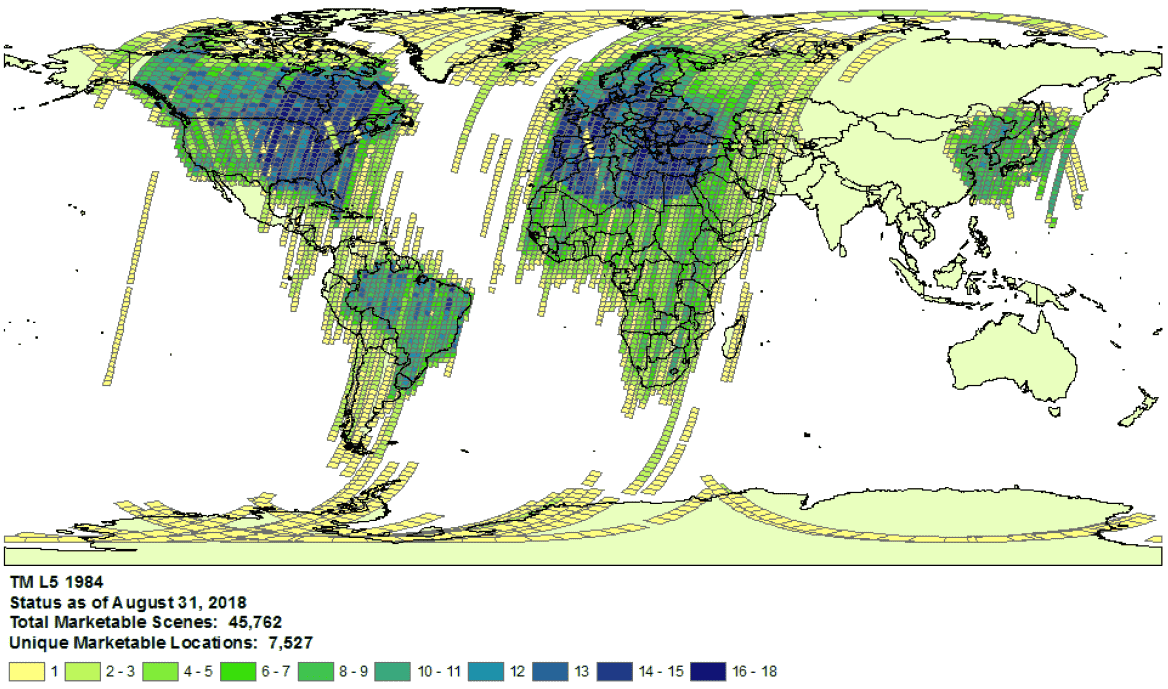
Contoh cakupan koleksi Landsat 5 untuk tahun 1984.
- Pilihan penyedia: data diserap ke dalam Earth Engine Data Catalog
dari penyedia yang dipilih per set data. Mungkin penyedia tidak menawarkan arsip misi lengkap. Misalnya, set data Landsat
ditransfer dari arsip USGS, yang diketahui tidak memiliki citra dari
stasiun penerima tertentu selama jangka waktu tertentu (lihat
upaya LGAC
untuk mengetahui informasi selengkapnya).
Landsat
Data Landsat diserap dari U.S. Geological Survey (USGS).
Konfirmasi
ketersediaan cakupan Landsat
untuk waktu dan area yang diinginkan.
Lakukan penelusuran di Earth Engine untuk mendapatkan daftar semua aset untuk waktu dan area minat. Pastikan tidak ada aset yang tidak sengaja
difilter dalam kode Anda.
Berikut adalah contoh skrip;
pastikan Anda mengimpor koleksi dengan tingkat dan tingkat pemrosesan
yang tepat (pelajari lebih lanjut
struktur koleksi Landsat).
Cari aset yang mungkin tidak ada di katalog USGS Earth Explorer (lihat panduan bantuan untuk mengetahui langkah-langkah mendetail tentang melakukan penelusuran dan memilih set data).
Pastikan Anda membandingkan produk dan tingkat pemrosesan yang tepat
(lihat struktur pengumpulan Landsat).
Perhatikan bahwa produk pantulan permukaan hanya dibuat untuk gambar Landsat dengan
level pemrosesan
L1TP.
Bagikan bukti mendetail tentang aset yang tidak ada dengan mengirimkan
pesan
bersama ID produk penyedia dan
link
ke skrip Earth Engine Code Editor yang mengonfirmasi tidak adanya aset.
Sentinel
Data Sentinel diserap dari
situs Copernicus Dataspace.
Pastikan
ketersediaan cakupan Sentinel untuk waktu dan area yang diinginkan (lihat
detail misi).
Catatan: Produk Sentinel-2 Level-2A dihasilkan secara sistematis di segmen darat di Eropa hanya sejak Maret 2018, dan produksinya diperluas ke seluruh dunia pada Desember 2018 (lihat Panduan Pengguna ESA untuk mengetahui detail selengkapnya).
Cuplikan tersebut pada akhirnya akan dibuat ulang sebagai bagian dari Koleksi 1.
Lakukan penelusuran di Earth Engine untuk mendapatkan daftar semua aset untuk waktu dan area minat. Pastikan tidak ada aset yang tidak sengaja
difilter dalam kode Anda. Berikut adalah
contoh skrip;
pastikan Anda mengimpor koleksi dengan tingkat pemrosesan
yang tepat.
Cari aset yang mungkin tidak ada di
katalog Copernicus.
Bagikan bukti mendetail tentang aset yang tidak ada dengan mengirimkan
pesan
bersama ID produk penyedia dan
link
ke skrip Earth Engine Code Editor yang mengonfirmasi tidak adanya aset.
MODIS
Data MODIS diserap dari
Land Processes Distributed Active Archive Center
(LP DAAC).
Lakukan penelusuran di Earth Engine untuk mendapatkan daftar semua aset untuk waktu dan area minat. Pastikan tidak ada aset yang tidak sengaja
difilter dalam kode Anda. Berikut adalah
contoh skrip;
pastikan Anda mengimpor produk yang diinginkan.
Cari aset yang mungkin tidak ada di
Koleksi Data USGS yang belum
ditambahkan ke Earth Engine. Buka folder yang sesuai dan identifikasi
direktori terbaru yang tersedia.
Set data yang diawali dengan "MOD" berada di
"Terra MODIS"
Set data yang diawali dengan "MYD" berada di
"Aqua MODIS"
Set data yang diawali dengan "MCD" berada di
"MODIS Gabungan"
Set data yang diawali dengan "VNP" berada di
"S-NPP VIIRS"
Bagikan bukti mendetail tentang aset yang tidak ada dengan mengirimkan
pesan
bersama ID produk penyedia dan
link
ke skrip Earth Engine Code Editor yang mengonfirmasi tidak adanya aset.
Kecuali dinyatakan lain, konten di halaman ini dilisensikan berdasarkan Lisensi Creative Commons Attribution 4.0, sedangkan contoh kode dilisensikan berdasarkan Lisensi Apache 2.0. Untuk mengetahui informasi selengkapnya, lihat Kebijakan Situs Google Developers. Java adalah merek dagang terdaftar dari Oracle dan/atau afiliasinya.
Terakhir diperbarui pada 2025-07-25 UTC.
[null,null,["Terakhir diperbarui pada 2025-07-25 UTC."],[[["\u003cp\u003eThis document provides guidance to determine if a Landsat, Sentinel, or MODIS asset is missing from the Earth Engine Data Catalog.\u003c/p\u003e\n"],["\u003cp\u003eUsers can verify potential missing assets by checking the provider's catalog and comparing it against the Earth Engine catalog.\u003c/p\u003e\n"],["\u003cp\u003eDetailed information, including the provider's product ID and an Earth Engine script, must be submitted when reporting missing assets.\u003c/p\u003e\n"],["\u003cp\u003eVariances in data availability may occur due to factors like processing levels, spatiotemporal coverage, and provider data archives.\u003c/p\u003e\n"]]],["To find missing assets in the Earth Engine Data Catalog, first, check provider catalogs (USGS, Copernicus, or LP DAAC) for coverage availability. Next, search Earth Engine, ensuring no filters exclude assets. Compare results to the provider's catalog. For Landsat, use USGS Earth Explorer; for Sentinel, use the Copernicus catalog; and for MODIS, use the USGS Data Pool. Finally, report any discrepancies to the Earth Engine team via a ticket, including the provider's product ID and an Earth Engine script link.\n"],null,["# Verify Missing Images in the Data Catalog\n\nThe purpose of this document is to help you determine if an asset is missing\nin the Earth Engine Data Catalog (currently Landsat, Sentinel, and MODIS).\n\nThe steps outlined describe how to:\n\n- Check for available assets in Earth Engine's and providers' catalogs.\n\n- Collect information needed to submit confirmation of a missing\n asset to the Earth Engine data team.\n\nCommon things to consider\n-------------------------\n\n- **Processing level**: not all images may be available for a given processing\n level or product. For instance, low-quality images may not be processed\n to the highest level.\n\n- **Spatiotemporal coverage**: a regular cadence is not\n guaranteed for each dataset. Variation in sensor tasking, image quality,\n and archive management can affect provider data availability.\n\n\nExample of Landsat 5\n[collection coverage](https://landsat.usgs.gov/usgs-landsat-global-archive) for\n1984.\n\n- **Provider choice** : data are ingested into the Earth Engine Data Catalog from a selected provider per dataset. It is possible that the provider does not offer a complete mission archive. For example, Landsat datasets are ingested from the USGS archive, which is known to be missing imagery from certain receiving stations for certain periods of time (see the [LGAC effort](https://www.usgs.gov/land-resources/nli/landsat/landsat-global-archive-consolidation?qt-science_support_page_related_con=3#qt-science_support_page_related_con) for more information).\n\nLandsat\n-------\n\nLandsat data are ingested from the\n[U.S. Geological Survey](https://www.usgs.gov/land-resources/nli/landsat)\n(USGS).\n\n1. Confirm\n [Landsat coverage availability](https://landsat.usgs.gov/usgs-landsat-global-archive)\n for the time and area of interest.\n\n2. Perform a search in Earth Engine to get a list of all assets for the time and\n area of interest. Take care to ensure no assets have been accidentally\n filtered out within your code.\n Here is an [example script](https://code.earthengine.google.com/975bff3a2ff955e5f884005b5dd2bafb);\n be sure you are importing the collection with the right tier and processing\n level (learn more\n [about the Landsat collection structure](https://developers.google.com/earth-engine/landsat#landsat-collection-structure)).\n\n3. Look for potentially missing assets in the\n [USGS Earth Explorer](https://earthexplorer.usgs.gov/) catalog (see the help\n guide for detailed steps on\n [performing a search](https://lta.cr.usgs.gov/EEHelp/ee_tutorial_search_criteria)\n and [selecting datasets](https://lta.cr.usgs.gov/EEHelp/ee_tutorial_search_datasets)).\n Make sure you are comparing the right products and processing levels\n ([see Landsat collection structure](https://developers.google.com/earth-engine/landsat#landsat-collection-structure)).\n Note that surface reflectance products are only generated for Landsat images with\n processing level\n [L1TP](https://www.usgs.gov/land-resources/nli/landsat/landsat-levels-processing).\n\n4. Share detailed evidence of missing assets by submitting a\n [ticket](https://issuetracker.google.com/issues/new?component=184406&template=1254745)\n with the provider's product ID and a\n [link](https://developers.google.com/earth-engine/playground#get-link)\n to an Earth Engine Code Editor script confirming the absence of the assets.\n\nSentinel\n--------\n\nSentinel data are ingested from the\n[Copernicus Dataspace site](https://dataspace.copernicus.eu/).\n\n1. Confirm\n Sentinel coverage availability for the time and area of interest (see\n [mission details](https://sentinel.esa.int/web/sentinel/missions)).\n\n *Note* : Sentinel-2 Level-2A products are systematically generated at the\n ground segment over Europe only since March 2018, and the production\n was extended to global in December 2018 (see\n [ESA User Guide](https://sentinel.esa.int/web/sentinel/user-guides/sentinel-2-msi)\n for more details).\n They will eventually be regenerated as a part of Collection 1.\n2. Perform a search in Earth Engine to get a list of all assets for the time and\n area of interest. Take care to ensure no assets have been accidentally\n filtered out within your code. Here is an\n [example script](https://code.earthengine.google.com/4bebc6b8b44807a2001bc34d49fc25eb);\n be sure you are importing the collection with the right processing\n level.\n\n3. Look for potentially missing assets in the\n [Copernicus catalog](https://dataspace.copernicus.eu/browser/).\n\n4. Share detailed evidence of missing assets by submitting a\n [ticket](https://issuetracker.google.com/issues/new?component=184406&template=1254745)\n with the provider's product ID and a\n [link](https://developers.google.com/earth-engine/playground#get-link)\n to an Earth Engine Code Editor script confirming the absence of the assets.\n\nMODIS\n-----\n\nMODIS data are ingested from the\n[Land Processes Distributed Active Archive Center](https://lpdaac.usgs.gov/)\n(LP DAAC).\n\n1. Perform a search in Earth Engine to get a list of all assets for the time and\n area of interest. Take care to ensure no assets have been accidentally\n filtered out within your code. Here is an\n [example script](https://code.earthengine.google.com/848200c362694900b6027b30b0e99677);\n be sure you are importing the intended product.\n\n2. Look for potentially missing assets in the\n [USGS Data Pool](https://lpdaac.usgs.gov/tools/data-pool/) that have not been\n added to Earth Engine. Navigate to the appropriate folder and identify the\n latest directories available.\n\n - Datasets starting with \"MOD\" are in\n \"[Terra MODIS](https://e4ftl01.cr.usgs.gov/MOLT/)\"\n\n - Datasets starting with \"MYD\" are in\n \"[Aqua MODIS](https://e4ftl01.cr.usgs.gov/MOLA/)\"\n\n - Datasets starting with \"MCD\" are in\n \"[Combined MODIS](https://e4ftl01.cr.usgs.gov/MOTA/)\"\n\n - Datasets starting with \"VNP\" are in\n \"[S-NPP VIIRS](https://e4ftl01.cr.usgs.gov/VIIRS/)\"\n\n3. Share detailed evidence of missing assets by submitting a\n [ticket](https://issuetracker.google.com/issues/new?component=184406&template=1254745)\n with the provider's product ID and a\n [link](https://developers.google.com/earth-engine/playground#get-link)\n to an Earth Engine Code Editor script confirming the absence of the assets."]]