お知らせ:
2025 年 4 月 15 日より前に Earth Engine の使用を登録したすべての非商用プロジェクトは、Earth Engine へのアクセスを維持するために
非商用目的での利用資格を確認する必要があります。
Data Catalog で不足しているイメージを確認する
コレクションでコンテンツを整理
必要に応じて、コンテンツの保存と分類を行います。
このドキュメントの目的は、Earth Engine データカタログ(現在は Landsat、Sentinel、MODIS)にアセットが不足しているかどうかを判断することです。
以下の手順では、次のことを行う方法について説明します。
一般的な考慮事項
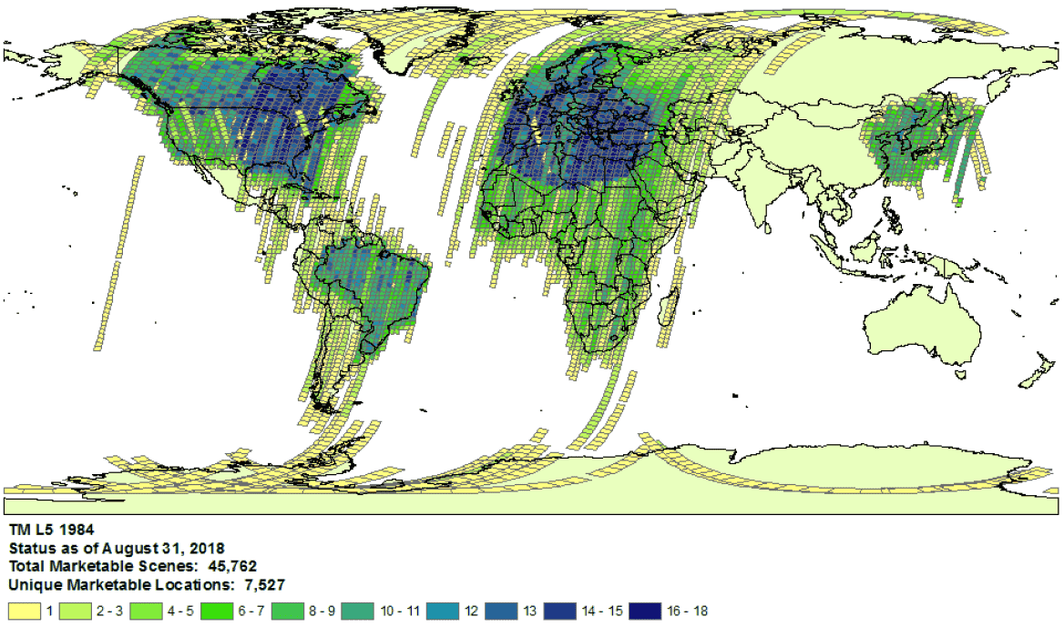
1984 年の Landsat 5 の収集範囲の例。
- プロバイダの選択: データは、データセットごとに選択したプロバイダから Earth Engine Data Catalog に取り込まれます。プロバイダが完全なミッション アーカイブを提供していない可能性があります。たとえば、Landsat データセットは USGS アーカイブから取り込まれますが、このアーカイブには特定の受信局からの画像が特定の期間欠落していることが知られています(詳細については、LGAC の取り組みをご覧ください)。
Landsat
Landsat データは、米国地質調査所(USGS)から取り込まれます。
対象の時間と地域の Landsat の撮影範囲の可用性を確認します。
Earth Engine で検索を実行して、対象の時間とエリアのすべてのアセットのリストを取得します。コード内でアセットが誤って除外されていないことを確認してください。以下にサンプル スクリプトを示します。適切な階層と処理レベルでコレクションをインポートしてください(Landsat コレクションの構造の詳細をご覧ください)。
USGS Earth Explorer カタログで、不足している可能性のあるアセットを探します(検索の実行とデータセットの選択の詳細な手順については、ヘルプガイドをご覧ください)。適切なプロダクトと処理レベルを比較していることを確認します(Landsat コレクションの構造をご覧ください)。地表反射率プロダクトは、処理レベルが L1TP の Landsat 画像に対してのみ生成されます。
プロバイダのプロダクト ID と、アセットが存在しないことを確認する Earth Engine コードエディタ スクリプトへのリンクを含むチケットを送信して、アセットがないことを示す詳細な証拠を共有します。
Sentinel
Sentinel データは Copernicus Dataspace サイトから取り込まれます。
対象の時間と地域で Sentinel の撮影範囲が利用可能であることを確認します(ミッションの詳細を参照)。
注: Sentinel-2 Level-2A プロダクトは、2018 年 3 月以降、ヨーロッパの地上セグメントでのみシステム的に生成されています。2018 年 12 月に、生成は全世界に拡大されました(詳細については、ESA ユーザーガイドをご覧ください)。最終的には、コレクション 1 の一部として再生成されます。
Earth Engine で検索を実行して、対象の時間とエリアのすべてのアセットのリストを取得します。コード内でアセットが誤って除外されていないことを確認してください。スクリプトの例を次に示します。正しい処理レベルでコレクションをインポートしてください。
Copernicus カタログで、不足している可能性のあるアセットを探します。
アセットがないことを示す詳細な証拠を共有するには、プロバイダのプロダクト ID と、アセットがないことを確認する Earth Engine コードエディタ スクリプトへのリンクを含むチケットを送信します。
MODIS
MODIS データは、Land Processes Distributed Active Archive Center(LP DAAC)から取り込まれます。
Earth Engine で検索を実行して、対象の時間とエリアのすべてのアセットのリストを取得します。コード内でアセットが誤って除外されていないことを確認してください。スクリプトの例を次に示します。目的の商品をインポートしていることを確認してください。
USGS データプールで、Earth Engine に追加されていない欠落しているアセットを探します。適切なフォルダに移動し、使用可能な最新のディレクトリを特定します。
アセットがないことを示す詳細な証拠を共有するには、プロバイダのプロダクト ID と、アセットがないことを確認する Earth Engine コードエディタ スクリプトへのリンクを含むチケットを送信します。
特に記載のない限り、このページのコンテンツはクリエイティブ・コモンズの表示 4.0 ライセンスにより使用許諾されます。コードサンプルは Apache 2.0 ライセンスにより使用許諾されます。詳しくは、Google Developers サイトのポリシーをご覧ください。Java は Oracle および関連会社の登録商標です。
最終更新日 2025-07-25 UTC。
[null,null,["最終更新日 2025-07-25 UTC。"],[[["\u003cp\u003eThis document provides guidance to determine if a Landsat, Sentinel, or MODIS asset is missing from the Earth Engine Data Catalog.\u003c/p\u003e\n"],["\u003cp\u003eUsers can verify potential missing assets by checking the provider's catalog and comparing it against the Earth Engine catalog.\u003c/p\u003e\n"],["\u003cp\u003eDetailed information, including the provider's product ID and an Earth Engine script, must be submitted when reporting missing assets.\u003c/p\u003e\n"],["\u003cp\u003eVariances in data availability may occur due to factors like processing levels, spatiotemporal coverage, and provider data archives.\u003c/p\u003e\n"]]],["To find missing assets in the Earth Engine Data Catalog, first, check provider catalogs (USGS, Copernicus, or LP DAAC) for coverage availability. Next, search Earth Engine, ensuring no filters exclude assets. Compare results to the provider's catalog. For Landsat, use USGS Earth Explorer; for Sentinel, use the Copernicus catalog; and for MODIS, use the USGS Data Pool. Finally, report any discrepancies to the Earth Engine team via a ticket, including the provider's product ID and an Earth Engine script link.\n"],null,["# Verify Missing Images in the Data Catalog\n\nThe purpose of this document is to help you determine if an asset is missing\nin the Earth Engine Data Catalog (currently Landsat, Sentinel, and MODIS).\n\nThe steps outlined describe how to:\n\n- Check for available assets in Earth Engine's and providers' catalogs.\n\n- Collect information needed to submit confirmation of a missing\n asset to the Earth Engine data team.\n\nCommon things to consider\n-------------------------\n\n- **Processing level**: not all images may be available for a given processing\n level or product. For instance, low-quality images may not be processed\n to the highest level.\n\n- **Spatiotemporal coverage**: a regular cadence is not\n guaranteed for each dataset. Variation in sensor tasking, image quality,\n and archive management can affect provider data availability.\n\n\nExample of Landsat 5\n[collection coverage](https://landsat.usgs.gov/usgs-landsat-global-archive) for\n1984.\n\n- **Provider choice** : data are ingested into the Earth Engine Data Catalog from a selected provider per dataset. It is possible that the provider does not offer a complete mission archive. For example, Landsat datasets are ingested from the USGS archive, which is known to be missing imagery from certain receiving stations for certain periods of time (see the [LGAC effort](https://www.usgs.gov/land-resources/nli/landsat/landsat-global-archive-consolidation?qt-science_support_page_related_con=3#qt-science_support_page_related_con) for more information).\n\nLandsat\n-------\n\nLandsat data are ingested from the\n[U.S. Geological Survey](https://www.usgs.gov/land-resources/nli/landsat)\n(USGS).\n\n1. Confirm\n [Landsat coverage availability](https://landsat.usgs.gov/usgs-landsat-global-archive)\n for the time and area of interest.\n\n2. Perform a search in Earth Engine to get a list of all assets for the time and\n area of interest. Take care to ensure no assets have been accidentally\n filtered out within your code.\n Here is an [example script](https://code.earthengine.google.com/975bff3a2ff955e5f884005b5dd2bafb);\n be sure you are importing the collection with the right tier and processing\n level (learn more\n [about the Landsat collection structure](https://developers.google.com/earth-engine/landsat#landsat-collection-structure)).\n\n3. Look for potentially missing assets in the\n [USGS Earth Explorer](https://earthexplorer.usgs.gov/) catalog (see the help\n guide for detailed steps on\n [performing a search](https://lta.cr.usgs.gov/EEHelp/ee_tutorial_search_criteria)\n and [selecting datasets](https://lta.cr.usgs.gov/EEHelp/ee_tutorial_search_datasets)).\n Make sure you are comparing the right products and processing levels\n ([see Landsat collection structure](https://developers.google.com/earth-engine/landsat#landsat-collection-structure)).\n Note that surface reflectance products are only generated for Landsat images with\n processing level\n [L1TP](https://www.usgs.gov/land-resources/nli/landsat/landsat-levels-processing).\n\n4. Share detailed evidence of missing assets by submitting a\n [ticket](https://issuetracker.google.com/issues/new?component=184406&template=1254745)\n with the provider's product ID and a\n [link](https://developers.google.com/earth-engine/playground#get-link)\n to an Earth Engine Code Editor script confirming the absence of the assets.\n\nSentinel\n--------\n\nSentinel data are ingested from the\n[Copernicus Dataspace site](https://dataspace.copernicus.eu/).\n\n1. Confirm\n Sentinel coverage availability for the time and area of interest (see\n [mission details](https://sentinel.esa.int/web/sentinel/missions)).\n\n *Note* : Sentinel-2 Level-2A products are systematically generated at the\n ground segment over Europe only since March 2018, and the production\n was extended to global in December 2018 (see\n [ESA User Guide](https://sentinel.esa.int/web/sentinel/user-guides/sentinel-2-msi)\n for more details).\n They will eventually be regenerated as a part of Collection 1.\n2. Perform a search in Earth Engine to get a list of all assets for the time and\n area of interest. Take care to ensure no assets have been accidentally\n filtered out within your code. Here is an\n [example script](https://code.earthengine.google.com/4bebc6b8b44807a2001bc34d49fc25eb);\n be sure you are importing the collection with the right processing\n level.\n\n3. Look for potentially missing assets in the\n [Copernicus catalog](https://dataspace.copernicus.eu/browser/).\n\n4. Share detailed evidence of missing assets by submitting a\n [ticket](https://issuetracker.google.com/issues/new?component=184406&template=1254745)\n with the provider's product ID and a\n [link](https://developers.google.com/earth-engine/playground#get-link)\n to an Earth Engine Code Editor script confirming the absence of the assets.\n\nMODIS\n-----\n\nMODIS data are ingested from the\n[Land Processes Distributed Active Archive Center](https://lpdaac.usgs.gov/)\n(LP DAAC).\n\n1. Perform a search in Earth Engine to get a list of all assets for the time and\n area of interest. Take care to ensure no assets have been accidentally\n filtered out within your code. Here is an\n [example script](https://code.earthengine.google.com/848200c362694900b6027b30b0e99677);\n be sure you are importing the intended product.\n\n2. Look for potentially missing assets in the\n [USGS Data Pool](https://lpdaac.usgs.gov/tools/data-pool/) that have not been\n added to Earth Engine. Navigate to the appropriate folder and identify the\n latest directories available.\n\n - Datasets starting with \"MOD\" are in\n \"[Terra MODIS](https://e4ftl01.cr.usgs.gov/MOLT/)\"\n\n - Datasets starting with \"MYD\" are in\n \"[Aqua MODIS](https://e4ftl01.cr.usgs.gov/MOLA/)\"\n\n - Datasets starting with \"MCD\" are in\n \"[Combined MODIS](https://e4ftl01.cr.usgs.gov/MOTA/)\"\n\n - Datasets starting with \"VNP\" are in\n \"[S-NPP VIIRS](https://e4ftl01.cr.usgs.gov/VIIRS/)\"\n\n3. Share detailed evidence of missing assets by submitting a\n [ticket](https://issuetracker.google.com/issues/new?component=184406&template=1254745)\n with the provider's product ID and a\n [link](https://developers.google.com/earth-engine/playground#get-link)\n to an Earth Engine Code Editor script confirming the absence of the assets."]]