Xác minh hình ảnh bị thiếu trong Danh mục dữ liệu
Sử dụng bộ sưu tập để sắp xếp ngăn nắp các trang
Lưu và phân loại nội dung dựa trên lựa chọn ưu tiên của bạn.
Mục đích của tài liệu này là giúp bạn xác định xem có tài sản nào bị thiếu trong Danh mục dữ liệu Earth Engine (hiện là Landsat, Sentinel và MODIS) hay không.
Các bước được nêu ra mô tả cách:
Những điều thường gặp cần cân nhắc
Cấp độ xử lý: không phải hình ảnh nào cũng có sẵn cho một cấp độ xử lý hoặc sản phẩm nhất định. Ví dụ: hình ảnh chất lượng thấp có thể không được xử lý đến mức cao nhất.
Phạm vi không gian và thời gian: không đảm bảo tần suất đều đặn cho mỗi tập dữ liệu. Sự khác biệt về việc giao việc cho cảm biến, chất lượng hình ảnh và việc quản lý bản lưu trữ có thể ảnh hưởng đến khả năng cung cấp dữ liệu của nhà cung cấp.
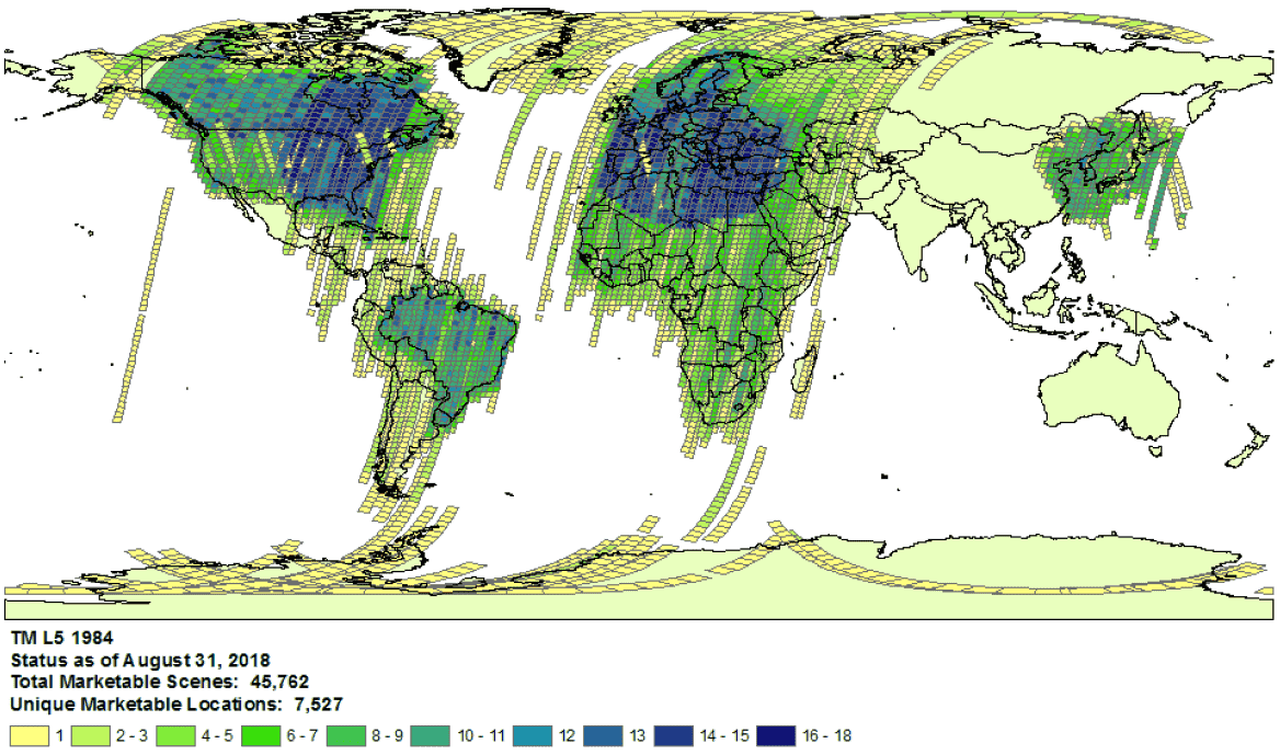
Ví dụ về mức độ bao phủ của dữ liệu thu thập của Landsat 5 trong năm 1984.
- Lựa chọn nhà cung cấp: dữ liệu được nhập vào Danh mục dữ liệu Earth Engine từ một nhà cung cấp đã chọn cho mỗi tập dữ liệu. Có thể nhà cung cấp không cung cấp bản lưu trữ đầy đủ về nhiệm vụ. Ví dụ: các tập dữ liệu Landsat được nhập từ kho lưu trữ USGS. Kho lưu trữ này được biết là thiếu hình ảnh từ một số trạm thu nhận trong một số khoảng thời gian nhất định (xem nỗ lực của LGAC để biết thêm thông tin).
Landsat
Dữ liệu Landsat được nhập từ Cơ quan Khảo sát Địa chất Hoa Kỳ (USGS).
Xác nhận tình trạng cung cấp dữ liệu Landsat tại thời điểm và khu vực bạn quan tâm.
Tìm kiếm trong Earth Engine để nhận danh sách tất cả tài sản tại thời điểm và khu vực mà bạn quan tâm. Hãy cẩn thận để đảm bảo không có thành phần nào bị vô tình lọc ra trong mã của bạn.
Dưới đây là tập lệnh mẫu; hãy đảm bảo bạn đang nhập tập hợp có cấp và cấp xử lý phù hợp (tìm hiểu thêm về cấu trúc tập hợp Landsat).
Tìm các tài sản có thể bị thiếu trong danh mục USGS Earth Explorer (xem hướng dẫn trợ giúp để biết các bước chi tiết về cách tìm kiếm và chọn tập dữ liệu).
Đảm bảo bạn đang so sánh đúng sản phẩm và cấp độ xử lý (xem cấu trúc tập hợp Landsat).
Xin lưu ý rằng các sản phẩm độ phản chiếu bề mặt chỉ được tạo cho hình ảnh Landsat có cấp xử lý là L1TP.
Chia sẻ bằng chứng chi tiết về việc thiếu thành phần bằng cách gửi một vé hỗ trợ kèm theo mã sản phẩm của nhà cung cấp và đường liên kết đến tập lệnh Trình chỉnh sửa mã Earth Engine xác nhận việc thiếu thành phần.
Sentinel
Dữ liệu Sentinel được nhập từ trang web Copernicus Dataspace.
Xác nhận phạm vi quan sát của Sentinel tại thời điểm và khu vực bạn quan tâm (xem thông tin chi tiết về nhiệm vụ).
Lưu ý: Các sản phẩm Sentinel-2 cấp 2A chỉ được tạo một cách có hệ thống tại phân đoạn mặt đất trên Châu Âu kể từ tháng 3 năm 2018 và quá trình sản xuất đã được mở rộng ra toàn cầu vào tháng 12 năm 2018 (xem Hướng dẫn sử dụng ESA để biết thêm thông tin chi tiết).
Cuối cùng, các tệp này sẽ được tạo lại trong Bộ sưu tập 1.
Tìm kiếm trong Earth Engine để nhận danh sách tất cả tài sản tại thời điểm và khu vực mà bạn quan tâm. Hãy cẩn thận để đảm bảo không có thành phần nào bị vô tình lọc ra trong mã của bạn. Dưới đây là một tập lệnh mẫu; hãy đảm bảo bạn đang nhập bộ sưu tập ở cấp độ xử lý phù hợp.
Tìm các thành phần có thể bị thiếu trong danh mục Copernicus.
Chia sẻ bằng chứng chi tiết về việc thiếu thành phần bằng cách gửi một vé hỗ trợ kèm theo mã sản phẩm của nhà cung cấp và đường liên kết đến tập lệnh Trình chỉnh sửa mã Earth Engine xác nhận việc thiếu thành phần.
MODIS
Dữ liệu MODIS được nhập từ Trung tâm lưu trữ chủ động phân phối quy trình trên đất liền (LP DAAC).
Tìm kiếm trong Earth Engine để nhận danh sách tất cả tài sản tại thời điểm và khu vực mà bạn quan tâm. Hãy cẩn thận để đảm bảo không có thành phần nào bị vô tình lọc ra trong mã của bạn. Sau đây là một tập lệnh mẫu; hãy đảm bảo bạn đang nhập sản phẩm dự định.
Tìm những thành phần có thể bị thiếu trong Bể dữ liệu USGS mà chưa được thêm vào Earth Engine. Chuyển đến thư mục thích hợp và xác định các thư mục mới nhất hiện có.
Các tập dữ liệu bắt đầu bằng "MOD" nằm trong "Terra MODIS"
Các tập dữ liệu bắt đầu bằng "MYD" nằm trong "Aqua MODIS"
Các tập dữ liệu bắt đầu bằng "MCD" nằm trong "MODIS kết hợp"
Các tập dữ liệu bắt đầu bằng "VNP" nằm trong "S-NPP VIIRS"
Chia sẻ bằng chứng chi tiết về việc thiếu thành phần bằng cách gửi một vé hỗ trợ kèm theo mã sản phẩm của nhà cung cấp và đường liên kết đến tập lệnh Trình chỉnh sửa mã Earth Engine xác nhận việc thiếu thành phần.
Trừ phi có lưu ý khác, nội dung của trang này được cấp phép theo Giấy phép ghi nhận tác giả 4.0 của Creative Commons và các mẫu mã lập trình được cấp phép theo Giấy phép Apache 2.0. Để biết thông tin chi tiết, vui lòng tham khảo Chính sách trang web của Google Developers. Java là nhãn hiệu đã đăng ký của Oracle và/hoặc các đơn vị liên kết với Oracle.
Cập nhật lần gần đây nhất: 2025-07-25 UTC.
[null,null,["Cập nhật lần gần đây nhất: 2025-07-25 UTC."],[[["\u003cp\u003eThis document provides guidance to determine if a Landsat, Sentinel, or MODIS asset is missing from the Earth Engine Data Catalog.\u003c/p\u003e\n"],["\u003cp\u003eUsers can verify potential missing assets by checking the provider's catalog and comparing it against the Earth Engine catalog.\u003c/p\u003e\n"],["\u003cp\u003eDetailed information, including the provider's product ID and an Earth Engine script, must be submitted when reporting missing assets.\u003c/p\u003e\n"],["\u003cp\u003eVariances in data availability may occur due to factors like processing levels, spatiotemporal coverage, and provider data archives.\u003c/p\u003e\n"]]],["To find missing assets in the Earth Engine Data Catalog, first, check provider catalogs (USGS, Copernicus, or LP DAAC) for coverage availability. Next, search Earth Engine, ensuring no filters exclude assets. Compare results to the provider's catalog. For Landsat, use USGS Earth Explorer; for Sentinel, use the Copernicus catalog; and for MODIS, use the USGS Data Pool. Finally, report any discrepancies to the Earth Engine team via a ticket, including the provider's product ID and an Earth Engine script link.\n"],null,["# Verify Missing Images in the Data Catalog\n\nThe purpose of this document is to help you determine if an asset is missing\nin the Earth Engine Data Catalog (currently Landsat, Sentinel, and MODIS).\n\nThe steps outlined describe how to:\n\n- Check for available assets in Earth Engine's and providers' catalogs.\n\n- Collect information needed to submit confirmation of a missing\n asset to the Earth Engine data team.\n\nCommon things to consider\n-------------------------\n\n- **Processing level**: not all images may be available for a given processing\n level or product. For instance, low-quality images may not be processed\n to the highest level.\n\n- **Spatiotemporal coverage**: a regular cadence is not\n guaranteed for each dataset. Variation in sensor tasking, image quality,\n and archive management can affect provider data availability.\n\n\nExample of Landsat 5\n[collection coverage](https://landsat.usgs.gov/usgs-landsat-global-archive) for\n1984.\n\n- **Provider choice** : data are ingested into the Earth Engine Data Catalog from a selected provider per dataset. It is possible that the provider does not offer a complete mission archive. For example, Landsat datasets are ingested from the USGS archive, which is known to be missing imagery from certain receiving stations for certain periods of time (see the [LGAC effort](https://www.usgs.gov/land-resources/nli/landsat/landsat-global-archive-consolidation?qt-science_support_page_related_con=3#qt-science_support_page_related_con) for more information).\n\nLandsat\n-------\n\nLandsat data are ingested from the\n[U.S. Geological Survey](https://www.usgs.gov/land-resources/nli/landsat)\n(USGS).\n\n1. Confirm\n [Landsat coverage availability](https://landsat.usgs.gov/usgs-landsat-global-archive)\n for the time and area of interest.\n\n2. Perform a search in Earth Engine to get a list of all assets for the time and\n area of interest. Take care to ensure no assets have been accidentally\n filtered out within your code.\n Here is an [example script](https://code.earthengine.google.com/975bff3a2ff955e5f884005b5dd2bafb);\n be sure you are importing the collection with the right tier and processing\n level (learn more\n [about the Landsat collection structure](https://developers.google.com/earth-engine/landsat#landsat-collection-structure)).\n\n3. Look for potentially missing assets in the\n [USGS Earth Explorer](https://earthexplorer.usgs.gov/) catalog (see the help\n guide for detailed steps on\n [performing a search](https://lta.cr.usgs.gov/EEHelp/ee_tutorial_search_criteria)\n and [selecting datasets](https://lta.cr.usgs.gov/EEHelp/ee_tutorial_search_datasets)).\n Make sure you are comparing the right products and processing levels\n ([see Landsat collection structure](https://developers.google.com/earth-engine/landsat#landsat-collection-structure)).\n Note that surface reflectance products are only generated for Landsat images with\n processing level\n [L1TP](https://www.usgs.gov/land-resources/nli/landsat/landsat-levels-processing).\n\n4. Share detailed evidence of missing assets by submitting a\n [ticket](https://issuetracker.google.com/issues/new?component=184406&template=1254745)\n with the provider's product ID and a\n [link](https://developers.google.com/earth-engine/playground#get-link)\n to an Earth Engine Code Editor script confirming the absence of the assets.\n\nSentinel\n--------\n\nSentinel data are ingested from the\n[Copernicus Dataspace site](https://dataspace.copernicus.eu/).\n\n1. Confirm\n Sentinel coverage availability for the time and area of interest (see\n [mission details](https://sentinel.esa.int/web/sentinel/missions)).\n\n *Note* : Sentinel-2 Level-2A products are systematically generated at the\n ground segment over Europe only since March 2018, and the production\n was extended to global in December 2018 (see\n [ESA User Guide](https://sentinel.esa.int/web/sentinel/user-guides/sentinel-2-msi)\n for more details).\n They will eventually be regenerated as a part of Collection 1.\n2. Perform a search in Earth Engine to get a list of all assets for the time and\n area of interest. Take care to ensure no assets have been accidentally\n filtered out within your code. Here is an\n [example script](https://code.earthengine.google.com/4bebc6b8b44807a2001bc34d49fc25eb);\n be sure you are importing the collection with the right processing\n level.\n\n3. Look for potentially missing assets in the\n [Copernicus catalog](https://dataspace.copernicus.eu/browser/).\n\n4. Share detailed evidence of missing assets by submitting a\n [ticket](https://issuetracker.google.com/issues/new?component=184406&template=1254745)\n with the provider's product ID and a\n [link](https://developers.google.com/earth-engine/playground#get-link)\n to an Earth Engine Code Editor script confirming the absence of the assets.\n\nMODIS\n-----\n\nMODIS data are ingested from the\n[Land Processes Distributed Active Archive Center](https://lpdaac.usgs.gov/)\n(LP DAAC).\n\n1. Perform a search in Earth Engine to get a list of all assets for the time and\n area of interest. Take care to ensure no assets have been accidentally\n filtered out within your code. Here is an\n [example script](https://code.earthengine.google.com/848200c362694900b6027b30b0e99677);\n be sure you are importing the intended product.\n\n2. Look for potentially missing assets in the\n [USGS Data Pool](https://lpdaac.usgs.gov/tools/data-pool/) that have not been\n added to Earth Engine. Navigate to the appropriate folder and identify the\n latest directories available.\n\n - Datasets starting with \"MOD\" are in\n \"[Terra MODIS](https://e4ftl01.cr.usgs.gov/MOLT/)\"\n\n - Datasets starting with \"MYD\" are in\n \"[Aqua MODIS](https://e4ftl01.cr.usgs.gov/MOLA/)\"\n\n - Datasets starting with \"MCD\" are in\n \"[Combined MODIS](https://e4ftl01.cr.usgs.gov/MOTA/)\"\n\n - Datasets starting with \"VNP\" are in\n \"[S-NPP VIIRS](https://e4ftl01.cr.usgs.gov/VIIRS/)\"\n\n3. Share detailed evidence of missing assets by submitting a\n [ticket](https://issuetracker.google.com/issues/new?component=184406&template=1254745)\n with the provider's product ID and a\n [link](https://developers.google.com/earth-engine/playground#get-link)\n to an Earth Engine Code Editor script confirming the absence of the assets."]]